Dare County officials will announce reentry plans for Hatteras Island tomorrow afternoon, after an assessment of storm damage has been made, according to a bulletin issued at 5:16 p.m. by Dare County Emergency Management.
DCEM’s Isaias Bulletin #5 further advises people to make their “final preparations” for the tropical storm, whose effects will be felt in the Outer Banks from late tonight into tomorrow morning.
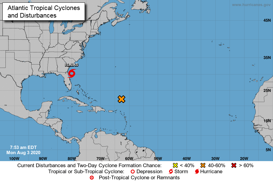
At 5 p.m. Tropical Storm Isaias was centered 60 miles south-southeast of Charleston, S.C., and 120 miles south-southwest of Myrtle Beach, S.C., according to the National Weather Service. It was traveling north at 15 mph and had maximum sustained winds of 70 mph.
Isaias “is still expected to strengthen and regain hurricane status before making landfall” near the South Carolina-North Carolina border, the National Hurricane Center said in a 5 p.m. report.
In terms of a storm’s impact, “there is little difference” between a strong tropical storm like Isaias and a Category One hurricane, according to the NHC’s report.
Isaias’s predicted northward trek into the interior of North Carolina will lessen its impact on the northeastern coastline.
The primary threat to the Outer Banks continues to be a storm surge that may cause flooding on the ocean and soundside. Tree damage and power outages also may occur.
The Morehead City Weather Forecast Office of the National Weather Service reported at 6 p.m. that there is an increased risk of flash flooding and strong tropical-storm force winds along, and west of, U.S. Highway 17 in Eastern North Carolina.
U.S. 17 is a north-south coastal highway that runs through Elizabeth City, Edenton, and Williamston, and continues farther south to New Bern, Jacksonville, and Wilmington.
Just another beach day: The Town’s “State of Emergency” proclamation, signed by Mayor Tom Bennett, does not prohibit ocean swimming.
Mayor Tom Bennett has determined that a “State of Emergency” exists in Southern Shores because of the “imminent approach of Tropical Storm/Hurricane Isaias” and has officially proclaimed its existence, as of noon today.
In his State of Emergency proclamation, Mayor Bennett readies law enforcement officers, Town employees, and other emergency management personnel to take necessary emergency action, in compliance with the Town’s Emergency Management Ordinance and Emergency Management Plan.
He also states that as “emerging events dictate,” he may issue subsequent proclamations “regarding but not limited to resident evacuation, curfew, purchase of alcohol, possession and transport of dangerous weapons and substances, etc.”
For an update from Dare County Emergency Management, see The Beacon’s previous posting about the Town’s scheduling of an emergency meeting tomorrow at 4 p.m. The only real change to earlier news is that Dare County is under a Storm Surge Warning now, as well as a Tropical Storm Warning.
Mayor Bennett refers to “Tropical Storm/Hurricane Isaias,” but there is no National Weather Service or National Hurricane Center forecast that calls for Isaias to be of hurricane-strength when it passes by Southern Shores.
As we reported earlier, Isaias is predicted to increase to a Category One hurricane between Charleston, S.C., and Wilmington, N.C., where most track models have it moving inland, as a tropical storm, before it shifts to the coast again, north of the Outer Banks.
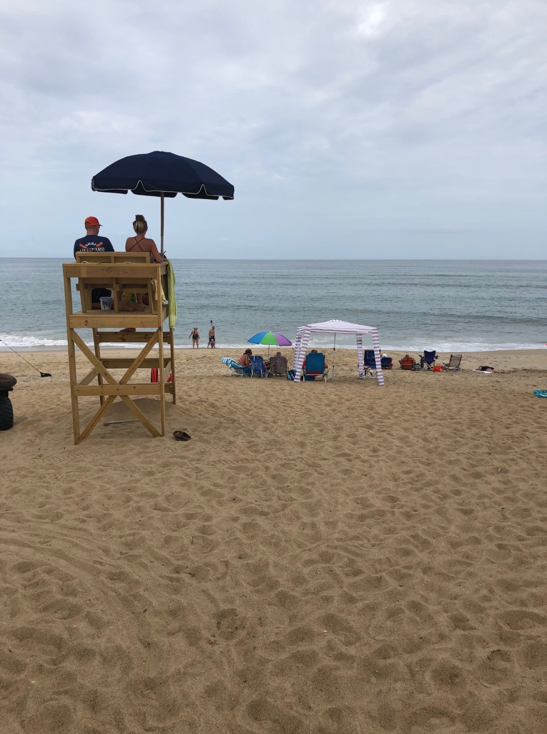
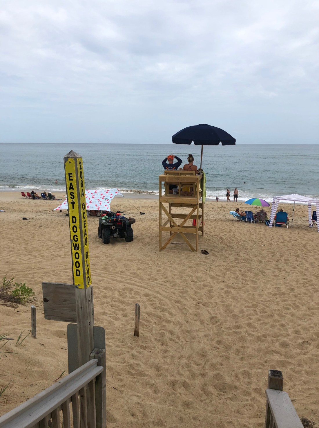
Lifeguards watch ocean swimmers this afternoon at the East Dogwood Trail access in Southern Shores. This photo was taken at 1:10 p.m., 51 minutes before the 2:01 p.m. low tide.
The Town Council has decided to hold an emergency meeting tomorrow at 4 p.m. in the Pitts Center in order to vote on the debris monitoring contract with Thompson Consulting and cancel the remainder of its previously scheduled 5:30 p.m. meeting.
The Town Council will move all other agenda items—including the draft revised recycling contract and budget amendments, outlined by The Beacon earlier today—to its 9 a.m. workshop meeting on Aug. 18, according to the emergency meeting notice issued this afternoon.
Those of you who read The Beacon’s meeting preview will know already about the debris monitoring contract—which is necessary for the Town to secure FEMA funding for storm-debris removal—and will have a jump on the workshop meeting in two weeks.
Since we posted the meeting preview, Dare County Emergency Management has issued Tropical Storm Isaias Bulletin #4, informing people that both a Tropical Storm Warning (previously reported by The Beacon) and a Storm Surge Warning are in effect for Dare County until further notice.
“In addition,” the bulletin says, “a Beach Hazards Statement has been issued and a High Surf Advisory will become effective early Tuesday morning.”
The Town of Southern Shores has issued a warning of soundside flooding, advising people to take necessary precautions now to protect their properties.
According to the DCEM, storm surge inundation may reach 2 to 4 feet above normally dry ground. You may monitor soundside water levels at https://fiman.nc.gov.
Isaias Bulletin #4 further advises that “ocean conditions are extremely dangerous and will remain so over the next few days. Everyone should stay out of the water, even experienced swimmers.”
When we visited the East Dogwood Trail beach access this afternoon, we observed several people swimming in the ocean. Surprisingly, we did not see a red no-swimming flag posted.
To obtain updated information about forecasted conditions for our area, visit http://www.weather.gov and type in your zip code in the upper-left search window. The Outer Banks will not experience the same storm conditions as Morehead City, N.C.
After the Town arrives at an agreement with Bay Disposal to restore transport of its curbside recycling to an actual recycling center, not an incinerator, the Town would be well-advised to consider an education campaign to inform both residents and visitors about which materials are recyclable and which are not.
The Town Council is on the verge of restoring true curbside recycling in Southern Shores after allowing Bay Disposal, LLC, to haul residents’ recyclables for eight months to a Portsmouth, Va. facility for incineration.
If the Council approves at its meeting tomorrow a draft amended contract between the Town and Bay Disposal—formerly known as Bay Disposal & Recycling, LLC—and both parties sign it, Bay Disposal will start taking Southern Shores’ recycling to a materials recycling facility (MRF) in Portsmouth owned by Recycling and Disposal Solutions (RDS), Inc.
For the RDS arrangement to go forward, the Council also must approve a fiscal year 2020-21 budget amendment of $5,701 to cover additional costs.
The Town Council is currently scheduled to meet tomorrow at 5:30 p.m. in the Pitts Center. The public may attend in person or join a Zoom videoconference.
Since last December, when Tidewater Fibre (TFC) Recycling of Chesapeake stopped accepting its Outer Banks recyclables because of contamination, Bay Disposal has been taking Southern Shores’ recyclables to Wheelabrator, a waste-to-energy facility that burns most of them.
A recycling specialist with the N.C. Dept. of Environmental Quality told The Beacon this spring that although Wheelabrator burns most recyclables it receives, it actually recycles metal materials. If it did not, the specialist said, it would be illegal under N.C. law for Bay Disposal to transport any recyclables there.
The N.C. DEQ identified RDS’s facility as an alternate disposal site for Outer Banks recyclables and was hopeful that RDS would build a new MRF in Elizabeth City. The recycling company, which has offices in Virginia Beach and Roanoke, Va., never found a suitable building to buy to do so, however, according to the recycling specialist.
Then-Interim Town Manager Wes Haskett reported at the Council’s May 5 meeting that he had heard from a “representative” of TFC that the Chesapeake recycling company would be willing to resume processing Southern Shores’ curbside recycling at a rate of $95 per ton, excluding collection and delivery. The Town Council rejected this offer as too expensive.
Instead, Town Manager Cliff Ogburn and Deputy Town Manager/Planning Director Haskett have worked with Town Attorney Ben Gallop on a revision of the contract that the Town has with Bay Disposal, with the understanding that Bay Disposal would transport Southern Shores recyclables to RDS’s Portmouth recycling center.
The amended contract would allow Bay Disposal to take the Town’s recyclables to Wheelabrator or another waste-to-energy facility only if RDS’s Portsmouth facility or another recycling facility becomes unavailable.
(The Beacon has written extensively about the recycling crisis in Southern Shores since last December. For a summary, see The Beacon, 5/10/20.)
The draft contract revision before the Town Council tomorrow amends an original three-year contract between Bay Disposal and the Town that dates to June 15, 2018 and expires June 30, 2021.
Other terms of the contract, such as those pertaining to its breach and termination, also have been amended, because the original terms were incomplete and/or disadvantageous to the Town. The new contract specifies that renewal may occur only for additional one-year periods.
As of July 29, Bay Disposal was “reviewing the draft amended contract, and we are waiting on confirmation of acceptance,” Mr. Ogburn wrote in a summary of this agenda item for the Town Council’s meeting packet.
After the contract is settled and signed, The Beacon is hopeful that Mr. Ogburn will give some attention to a public-education effort to inform both residents and visitors about what is recyclable and what is not.
BEACH STUDY MONIES, DEBRIS REMOVAL
In other agenda business, the Town Council is expected to amend the current fiscal year budget to pay Coastal Protection Engineering of North Carolina, Inc.—formerly known as APTIM—more monies for beach profiling, and to approve a debris monitoring contract with Thompson Consulting, LLC, whom Dare County identified as the low bidder in a Request for Proposal it released.
The debris monitoring contract that the Town would have “mirrors” the one that Dare County has with Thompson, according to Mr. Ogburn’s meeting summary.
For the town to maintain its Federal Emergency Management Agency (FEMA) reimbursement for debris removal, it must monitor its debris removal operations, Mr. Ogburn explains in his written overview.
Monitoring “requires comprehensive observation and documentation of debris removal work performed from the point of debris collection to final disposal,” the Town Manager writes.
(Many thanks to our new Town Manager for the item summaries that he is writing for the Town Council’s meeting packet. These well-written, dated summaries explain the background of an agenda item; give the Town Staff’s recommendation on the item; and indicate the action that the Town Staff is requesting from the Council. They are a great asset to the public.)
Coastal engineer CPE-NC seeks $18,039 to prepare a 2020 beach profile analysis and report based on “profile data” it has already acquired. Profiling looks at shoreline and sand-volume changes.
Although it is well-known that East Coast beaches are at their widest in July and August, CPE-NC collected its data for purposes of evaluating the current status of the Southern Shores coastline before June 30. It did the same last year, with its May analysis.
CPE-NC’s initial 2017 study was conducted in December, when the beaches are their most eroded. They restore themselves in the summertime, according to all of the coastal environmental experts interviewed by The Beacon for past articles.
The Beacon questions the need for an annual beach profile study this year. Not only is short-term assessment of the coastline of little value, the Town has decided to do beach nourishment in 2022, regardless of the state of the coastline.
The Town Council previously authorized an appropriation of $17,357 to CPE-NC for the “profile data acquisition,” $5,208 of which was not dispensed during last year’s fiscal year budget and must be added to the current fiscal year budget. Thus, the Town is spending more than $35,000 on its 2020 beach profile and will likely pay for another profile next year.
PUBLIC COMMENTS
There will be two public-comment periods during the Town Council’s meeting, one before the Council takes up any business on the agenda and the second after it finishes its business. You may speak for up to three minutes in person at the meeting or email written comments to Town Clerk Sheila Kane to be read aloud by the Mayor or the Mayor Pro Tem. You also have the option of speaking for up to three minutes via Zoom.
To send written comments, email Ms. Kane at skane@southernshores-nc.gov. Be sure to include your name and address and indicate in the email subject line: “Public comment for Town Council meeting, 8/4/20.”
If you participate by Zoom, you may press the chat button during the meeting to tell Ms. Kane that you would like to speak during one or both of the public-comment periods.
The meeting ID on Zoom is 929 2956 6855; and the passcode is 576193.
The Outer Banks is now under a Tropical Storm Warning, an upgrade from yesterday’s Tropical Storm Watch, according to the National Weather Service.
As of 8 a.m., Tropical Storm Isaias was 100 miles east-southeast of Jacksonville, Fla., having remained well off-shore of the Florida coast as it passed by. It is now moving north at 13 mph., an increase in yesterday’s speeds of 7-9 mph.
Isaias’s maximum sustained winds have increased to 70 mph, the National Weather Service reports, but it is still only of tropical-storm intensity, not hurricane-intensity. Dry air and wind shear continue to impede Isaias’s organization into a more intense storm.
The National Weather Service has forecasted the possibility that Isaias could strengthen into a hurricane between Charleston, S.C., and Wilmington, N.C., and has issued a Hurricane Warning for that area. A tropical storm becomes a Category One hurricane when its winds near the center reach 74 mph.
In Southern Shores, we are likely to experience heavy rains—with the smaller raindrops typical of tropical storms—and strong winds, starting late tonight and continuing into tomorrow. Storm surge could result in flooding, especially on the soundside.
No one should tempt fate today by swimming in the ocean. But today should offer some sunshine and calm before the storm.
As a veteran of dozens of tropical storms and hurricanes, I know that NWS predictions often do not pan out, so I am prepared, but also watchful for changes in the storm’s forecasted scenario.
My biggest fear is damage from fallen trees and other tree debris in the Southern Shores woods. Everyone should move their vehicles to higher ground, and away from trees, and secure objects outside that could become damaging projectiles.
All storm-savvy Outer Bankers know about “flying projectiles”!
The Beacon will post news of bulletins issued today by Dare County Emergency Management. Please see our reports about DCEM’s first three Isaias bulletins for more information about the storm’s threat and Dare County’s response.
We will try to keep you updated on what Isaias actually does, in addition to what predictions suggest it may do. Enjoy your Monday.
Tropical Storm Isaias may cause some soundside flooding in low-lying areas in Southern Shores that are affected by southerly winds, according to Dare County Emergency Management.
A Tropical Storm Watch became effective in Dare County at 11 a.m. today, indicating that tropical storm conditions are possible locally through Tuesday, according to a bulletin issued this afternoon by Dare County Emergency Management.
In its Isaias Bulletin #3, DCEM also acknowledges the disappointment that vacationers to Hatteras Island feel over having been ordered by Dare County to evacuate yesterday, starting at noon. Hatteras Island residents and property owners were ordered to leave today, starting at 6 a.m.
“[I]t is important to understand that evacuation decisions are made in the interest of public health and safety,” DCEM says in defense of the county’s evacuation orders.
Referring again to the vulnerability of N.C. Hwy. 12 on Hatteras Island, DCEM continues: “. . . As roads become covered with sand and water, it becomes difficult, sometimes impossible, for law enforcement, fire and emergency medical service personnel to respond to calls for assistance in a timely manner. In recent years, storms with forecasts similar to Isaias have caused road closures and the loss of personal property. Safety of residents and visitors is our top priority.”
The remainder of Bulletin #3, which was issued at 4:14 p.m., repeats the content of this morning’s Bulletin #2.
Southern Shores will have its regular trash collection tomorrow. The Town has not issued any special instructions or bulletins related to the tropical storm.
As of 2 p.m. today, Tropical Storm Isaias was 75 miles east-southeast of Vero Beach, Fla., moving northwesterly at 9 mph. Its center has remained off-shore.
Because Isaias’s heaviest rains and strongest winds have been to the east of its center, according to the National Weather Service, the Florida coast has been spared severe damage.
Dare County officials decided not to take any further preventive action this morning in response to Isaias, which is now a slow-moving tropical storm, not a hurricane, after receiving an update from the National Weather Service.
“While an evacuation order is not anticipated,” Dare County Emergency Management reported in a 10 a.m. bulletin, “it is imperative for everyone to keep their guard up and pay close attention to updated weather forecasts from the National Weather Service because the Outer Banks will experience impacts.”
Dare County remains under a State of Emergency, according to DCEM’s Isaias Bulletin #2, and the mandatory evacuation orders issued yesterday for Hatteras Island are still in effect, because of the “vulnerability” of N.C. Hwy 12, which is the only road access to and from the island.
As of 8 a.m., Tropical Storm Isaias was located 40 miles southeast of West Palm Beach, Fla., according to the National Weather Service. It has maximum sustained winds of 65 mph. and is moving slowly northwest at 8 mph.
An updated storm track today shows the storm passing by the Outer Banks on Tuesday. Wind effects from Isaias may be experienced locally late on Monday.
Ordinarily, the warm water Isaias is passing over would support the tropical storm’s intensification, but it is having to contend with dry air and wind shear that have not allowed it to become “well-organized,” according to the National Hurricane Center.
Forecast models “do not show the shear abating,” the NHC reported this morning, and “that window of opportunity for it to re-strengthen is closing.”
This morning’s DCEM bulletin warns of “storm surge inundation” on the Outer Banks that may produce ocean overwash and soundside flooding of “1 to 2 feet above normally dry ground, and up to 3 feet in some areas.”
“Some vulnerable spots along Hwy. 12 on Hatteras Island “are already experiencing minor ocean overwash during periods of high tide,” the bulletin reports.
Soundside flooding is likely to occur “in low-lying areas, at spots that are impacted by southerly winds,” the bulletin warns, particularly from Manteo to Kitty Hawk.
A high risk of rip currents and hazardous ocean conditions exists at all Outer Banks beaches over the next few days, according to the DCEM bulletin, which advises all beachgoers to stay out of the water and obey red-flag warnings.
In yesterday’s emergency declaration, Dare County prohibited ocean swimming off of Hatteras Island, but it made an exception for surfers. (See The Beacon, 8/1/20.)
For updated information from DCEM, the National Park Service, and the towns of Southern Shores, Duck, Kitty Hawk, Kill Devil Hills, Nags Head, and Manteo, visit darenc.com/isaias.
Dare County’s state of emergency also includes a ban on ocean swimming off Hatteras Island. It does not address ocean conditions on the northern Dare beaches.
Dare County issued a state of emergency at 11 a.m. today and ordered a mandatory evacuation for Hatteras Island, starting at noon, according to a Hurricane Isaias bulletin issued by Dare County Emergency Management.
Local decision-making officials will meet tomorrow morning, the bulletin announced, to determine whether a mandatory evacuation order will be issued for the Dare County towns north of Oregon Inlet, which include Manteo, Nags Head, Kill Devil Hills, Kitty Hawk, Southern Shores, and Duck.
According to Hurricane Isaias Bulletin #1, “local officials”—who were not identified—met this morning via video conference to receive a briefing from the National Weather Service about the potential effects of Isaias on Dare County. They concluded that ordering a state of emergency and an evacuation of Hatteras Island was prudent.
Today’s “declaration of a state of emergency” was signed by Bob Woodard, chairman of the Dare County Board of Commissioners, with the consent of all of the town mayors, who sit on the Dare County Control Group, except Manteo Mayor Bobby Owens, who named a designee to give consent.
As of 11 a.m., the storm was still over the Bahamas and moving northwesterly at 12 mph, five mph slower than its rate of speed yesterday. Its strongest winds have been reported to be 80 mph.
Dare County’s mandatory evacuation order applies to what is known as “Evacuation Zone A,” which covers all areas of Hatteras Island, including the unincorporated villages of Rodanthe, Waves, Salvo, Avon, Buxton, Frisco, and Hatteras Village.
“Evacuation Zone B” covers the Dare County areas north of Oregon Inlet.
Visitors to Hatteras Island must start evacuating today at noon, while residents and property owners have until 6 a.m. tomorrow before the evacuation order directed to them takes effect.
Today’s DCEM bulletin also calls attention to Dare County’s new online reentry permitting system, which is now in effect.
According to the bulletin, only reentry permits for the current calendar year are valid, but residents may still use a valid driver’s license with a Dare County address or a current tax bill or parcel data sheet with matching government-issued ID for reentry.
A left turn on to South Dogwood Trail from U.S. Hwy. 158-east will be prohibited today and tomorrow from 11 a.m. to 8 p.m. to deter vacationers from cutting through the Southern Shores residential area instead of remaining on the thoroughfare to the northern beaches.
Northbound motorists in vehicles with out-of-town license plates poured through Southern Shores today ahead of the 11 a.m. prohibition of the left turn at U.S. Hwy. 158-east and South Dogwood Trail.
From what we observed on Hickory Trail this morning, vacationers have not been deterred by the threat of Hurricane Isaias—at least, not enough to postpone their arrivals.
As you know, the left-turn prohibition will be in effect today and tomorrow from 11 a.m. to 8 p.m. during the fourth and last no-left-turn weekend of the summer.
So far, there is no word from the Dare County Control Group about an evacuation order ahead of Hurricane Isaias, which is likely to have weakened by the time it reaches an area near the northern Outer Banks on Monday.
Hyde County issued a mandatory evacuation order yesterday for all visitors and property owners on Ocracoke Island. Visitors were ordered to leave yesterday at noon, and non-resident and resident property owners were ordered to evacuate at 6 a.m. today.
N.C. Governor Roy Cooper also declared a state of emergency yesterday because of the potential impact of Isaias to the North Carolina coastline.
Please feel free to post comments here or on The Beacon’s Facebook page about traffic conditions today or about any issues related to the storm.
We will report on any official action taken by Dare County. Dare County Emergency Management announced yesterday that an update bulletin on the storm would be posted on its website by noon today.