The Southern Shores Planning Board is stymied.
After nearly a year of trying—albeit with months of interruptions spent on other pressing business (think SAGA)—the Board cannot decide how to measure a lot to determine its width.
Question: Where on a lot do you take a width measurement?
At its most recent meeting March 18, the Board discussed yet again this seemingly simple calculation. And yet again, the Board failed to resolve it, sending the latest Zoning Text Amendment (ZTA) on lot width back to the Town staff for another go-round.
This makes four times, by our count, that the Board has shrugged its collective shoulders.
The hour-and-twenty-minutes consumed two weeks ago by the Planning Board in another discussion about minimum lot width can best be described as bogged down and digressive, albeit earnestly so. Its struggle in reaching a solution seems sincere. Its failure to do so, nonetheless, is perplexing.
(Regular Board member Jan Collins did not attend the meeting; First Alternate Michael Zehner sat in for her, joining the four other regular members.)
How would you measure lot width?
‘A MOVING TARGET’
The Board first took up a lot-width ZTA, designated ZTA 23-01, on April 17, 2023. The ZTA it most recently critiqued is ZTA 23-05. The Board sent a version of a lot-width ZTA back to staff for more work on April 17, May 15, and Dec. 18, 2023, and now March 18, 2024.
On June 6, 2023, the Town Council enacted, by a 3-2 vote, a “stopgap” ZTA 23-03, mandating that all lots created in the residential and government/institutional districts after June 6, must have the required minimum width uniformly from front to back. This Town Code amendment essentially mandated rectangular lots.
Minimum lot widths, which are set forth in the Town Code, vary according to zoning district. In the RS-1 residential district, where most people live, the minimum lot width is 100 feet, the presumption being that most lots are 100 feet-by-200 feet and measure 20,000 square feet in size, another Town Code minimum requirement.
Some Planning Board members brought up eliminating minimum lot width—at least, in the RS-1 district— and trusting that the minimum lot size of 20,000 square feet would preserve the low-density character of Southern Shores neighborhoods.
It is only on newly platted lots—created through recombination or subdivision—that the width measurement is relevant. Many lots exist in Southern Shores now that are not 100 feet wide at any point; they are considered legally permitted nonconformities. The concern is with new lots.
Planning Board Chairperson Andy Ward colorfully described lot width at the meeting as “a moving target.”
“You’ve got to hit 100 feet somewhere on [a] lot, moving front to back,” said Mr. Ward, who argued strongly in favor of maintaining the minimum 100-foot width, which “has always been there.” We believe most longtime homeowners in Southern Shores would agree.
“You’ve got to hit 100 feet at some point on a newly subdivided lot,” he continued, without, unfortunately, suggesting where. How about in the middle?
Perhaps, Deputy Town Manager/Planning Director Wes Haskett offered, you could require a lot “to maintain 100 feet after it gets to that point,” going from front to back—whatever that point may be. This would account for cul-de-sac lots that are shaped like pieces of a pie and have concerned the Board quite a bit in its deliberations.
By the time Mr. Haskett polled the Board on a few questions relevant to his path forward in drafting another revised Zoning Text Amendment (23-06?)—including whether a lot must be 100 feet wide “at some point”—two members were asking what the “objective” and “goal” of the ZTA currently before them was.
Have they forgotten the context? Or has the context become obscure and/or irrelevant with all of the revisions?
We will refresh their memories, and yours, and risk getting bogged down, too.
CONTEXT: THE RECOMBINATION THAT EXPOSED AMBIGUITY
On April 20, 2023, we laid out the original context in a report of the Planning Board’s April 17, 2023 meeting that was headlined “Planning Board Grapples With Proposed Revision of Lot Width Requirement; Town Seeks to Eliminate Ambiguity.”
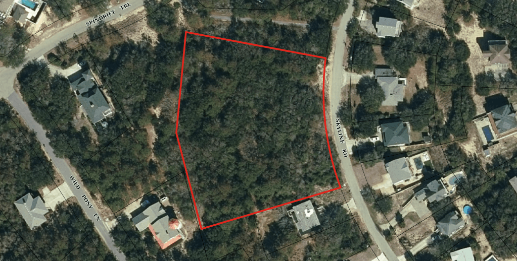
As we explained then, the Town Council requested a ZTA amending the Town Code’s lot-width ordinances after it reversed an October 2022 decision by the Board of Adjustment against property owners who sought to recombine an 80,000-square-foot tract land at 55 Skyline Road into four smaller buildable parcels. (See photo above.)
Operating as Skyline Oaks Properties LC (“Skyline Oaks”), the property owners wanted to situate two of their proposed new smaller lots behind the other two, so that the rear two would not front on Skyline Road. Mr. Haskett turned them down.
Although each of the new lots would measure 100 feet in width, their configuration persuaded Mr. Haskett, serving in his capacity as Zoning Administrator, to deny approval of Skyline Oaks’ recombination plat because it would create nonconforming lots in violation of the lot-width requirement in the RS-1 residential district.
(See The Beacon, 10/1/22, for even more background.)
In reaching his decision, Mr. Haskett applied the then-current language in sec. 36-57 of the Town Code, defining “lot width” as “the width of a lot at a required building setback line measured at right angles to depth” and “building setback line” as a line that is “parallel to or concentric with the street right-of-way establishing the minimum allowable distance between such right of way and the nearest portion of any building.”
Then-Town Code sec. 36-202(d)(2) specified that the 100-foot minimum lot width in the RS-1 district was to be “measured at the building setback line.”
(We appreciate the difficulty in interpreting the Code, but for reasons we do not understand, the word “minimum” was read differently by BOA members and by the Town and the property owners.)
In a written decision, Mr. Haskett explained how he interpreted the applicable ordinances and calculated the 100-foot width: “[A]ll of the proposed lots,” he wrote, “should have a minimum width of 100 feet measured at a line that is parallel to and 25 feet from the current right-of-way, Skyline Rd.”
He essentially equated the “building setback line” with the front setback line, which is 25 feet from the street. The building setback line, therefore, was the same as the lot-width line, or the “point” that Mr. Ward was trying to identify at the Board’s latest meeting.
The Board of Adjustment is a quasi-judicial body comprised of the same five members who sit on the Planning Board. Among its functions, the BOA hears appeals by property owners from administrative decisions by the Town, such as the denial of Skyline Oaks’ recombination.
After a hearing on the merits, the Board agreed, 3-2, with Mr. Haskett’s interpretation of the ordinances, and the property owners appealed the decision to the Superior Court of Dare County.
The Town Council subsequently (and quickly) intervened to enter into a consent decree with Skyline Oaks, resolving the matter in the property owners’ favor. The Council overruled Mr. Haskett’s interpretation and tasked him with clearing up the ambiguities in the Town Code ordinances pertaining to lot width.
FIRST ATTEMPT AT ELIMINATING AMBIGUITY
In the Town-submitted first proposed draft of ZTA 23-03, the meaning/definition of lot width was changed to “minimum horizontal distance between the side lot lines of a lot measured from the front lot line at right angles to the rear lot” and the RS-1 requirement was changed to “100 feet (measured from the front lot line at right angles to the rear lot line).”
(The new language used for the RS-1 minimum width was repeated in the other relevant Code sections on residential districts RS-8, RS-10, and R-1 and the GI district. This has been the case all along.)
We understand why the Planning Board rejected this language on April 17, 2023 and asked Mr. Haskett to revisit it. It is cumbersome and does not allow for irregularities, such as the cul-de-sac example. We were disappointed, however, that the Board did not propose alternate language, although it was aware of and considered other definitions.
This is not a wheel that needs reinventing. The American Legal Publishing, e.g., whose attorneys and editors have been assisting municipalities with ordinance codification for nearly 90 years, has posted a serviceable definition of lot width online. We quote it below.
SECOND ATTEMPT AT ELIMINATING AMBIGUITY
In the second proposed draft of ZTA 23-03, the definition of lot width was changed to “horizontal distance between the side lot lines of a lot,” and the RS-1 requirement was changed to “100 feet (measured at the front lot line).”
Needless to say, the Planning Board asked for another do-over, expressing a continued concern for cul-de-sac lots and other irregular-shaped lots.
THIRD ATTEMPT: A STOPGAP WRITTEN BY THE TOWN ATTORNEY
The draft of ZTA 23-03 approved by the Town Council on June 6, 2023, returned to the earlier language, specifying that “lot width means minimum horizontal distance between the side lot lines of a lot measured from the front lot line at right angles to the rear lot line,” and the calculation of width “for all lots created after June 6, 2023,” in the RS-1 district would be100 feet “measured from the front lot line at right angles to the rear lot line.”
Rectangles are in; irregular lots are out.
LATEST ATTEMPT, ZTA 23-05
Two weeks ago, the Planning Board considered this language:
“Lot width” means the “width of a lot at the required building setback line measured at right angles to the rear lot line.”
“Building setback line” means “a line parallel to or concentric with the front lot line establishing the allowable distance between the front lot line and the nearest portion of any building … [etc.]”
The word “minimum,” modifying “allowable distance,” was deleted.
ZTA 23-05’s language about minimum lot width in RS-1 reverts to the pre-June 6, 2023 language, specifying 100 feet “(measured at the building setback line).”
The new proposed language also states that for “lots that front a cul-de-sac, the building setback line shall be established 25 feet from the front lot line, or the point where the lot is 100 feet wide, whichever distance is closer to the front lot line,” and “for all other lots, the building setback line shall be established 25 feet from the front lot line.”
Before reaching this revision, Mr. Haskett proposed in an earlier draft, considered Dec. 18, 2023 by the Planning Board, that the building setback line on a lot that fronts a cul-de-sac could be established up to 80 feet from the front lot line. The Board rejected this suggestion.
Have you/we bogged down yet? No?
What about ambiguity? Has it been eliminated, as the Town Council requested?
It’s not surprising that the Planning Board bogged down with this new emphasis on “building setback line,” spending too much time on the difference between the building setback line and the “lot-width line,” a term that Mr. Haskett suggested invoking, but which has not been created yet.
The building setback line relates to where on a lot a structure may be built in relation to the front lot line. As Board members pointed out, repeatedly, it should not be used in defining lot width.
GOING FORWARD WITH ANOTHER ZTA
The American Legal Publishing offers the following definitions:
LOT WIDTH: “is the horizontal distance between the side lot lines, measured at right angles to the lot depth at a point midway between the front and rear lot lines.”
LOT DEPTH: “is measured along an imaginary straight line drawn from the midpoint of the front property line of the front property line of the lot to the midpoint of the rear property line.”
If depth runs vertically and width runs horizontally, a right angle can be achieved and measured.
What these definitions do is put the lot width measurement at the midway depth point between the front and rear lot lines.
Whatever the Planning Board—and the Town Council, in time—decide to do about defining lot width, we strongly recommend that they streamline the applicable ordinances so that lot width is only defined in sec. 36-57, and the width requirements in the ordinances for each zoning district refer only to the minimum number of feet.
Thus, if you consulted Code sec. 36-202(d)(2), you would learn that the minimum lot width is 100 feet, but you would have to read the definition of lot width in sec. 36-57 to learn how the 100 feet are measured. A referral to sec. 36-57 could be inserted next to the lot width requirement for each zoning district.
All the Planning Board has to do is pick its point or points on a lot for measuring horizontal distance—stop its targets from moving—and be fair about its choices.
We are of the mind that the minimum lot widths in the various districts should be maintained.
To be continued.
AND A WORD ABOUT ZTA 24-02 AND TREE REMOVAL
After the Planning Board voted unanimously not to approve ZTA 23-03, it shifted into a discussion about ZTA 24-02, which requires a commercial property owner to get a lot disturbance-stormwater management permit from the Town before removing from an unimproved lot any trees that are greater than 6 inches in diameter, 4.5 feet above the ground, and within a front, side, or rear yard setback area.
The proposed ZTA, which amends Code section 36-171, makes such tree removal without a permit an offense that is punishable by a civil penalty.
The rub with this ZTA, as we noted in our 3/16/24 preview of the Planning Board’s meeting, is that it is what we termed a “watered-down” version of an earlier version of the measure that imposed this permit requirement on property owners in all zoning districts. We viewed the original ZTA as a tool to prevent stormwater runoff in town, which is a major problem.
The earlier version also did not restrict the location of the trees to what Mr. Haskett referred to as “buffer” areas. It applied to trees throughout an unimproved lot.
Mr. Haskett announced at the Board’s February meeting that “the Town” was withdrawing the earlier version, which was part of ZTA 24-01, and redrafting it in a separate zoning text amendment. He gave no reason for the revision.
The Town Council reportedly passed ZTA 24-01, with a few revisions, at its March 12 meeting. One of its parts amends the Town Code to mandate 20-foot buffers between mixed-use group developments and commercial zoning, whenever they abut a residential district or a planned unit development, such as the Southern Shores Landing.
So what exactly does the new ZTA 24-02 do that the newly enacted ZTA 24-01 has not already done?
Chairperson Ward asked Mr. Haskett several times why “residential tree removal [was] pulled out” of the ZTA and never received a satisfactory response. He also said several times that he wanted to see the residential districts covered by the ZTA, and a majority of the Board appeared to agree with him.
Here’s our rub: Neither Mr. Ward nor any other Planning Board member made a motion to amend ZTA 24-02 by changing the text to include residential districts. It would have been a simple matter of deleting five words. Members seemed to believe either that they couldn’t do that—which they can—or that if they were to do that, they would deprive the public of “notice.”
In our next blog, we will explore the Board’s decision to put the residential districts on “the backburner,” as Mr. Ward said.
After spending an hour criticizing the ZTA, as presented, the Board recommended its approval, by a 4-1 vote, with the Chairperson casting the only dissenting vote.
Upon suggestion by Mr. Haskett, the Board also recommended to the Town Council, by consensus, that it authorize the draft of another ZTA that would include residential districts.
The Town Council will hold a public hearing on ZTA 24-02 at its April 9 meeting.
To be continued.
By Ann G. Sjoerdsma, 4/3/24
