The Southern Shores Entry Corridor Enhancement Committee will present on Tuesday (Jan. 27) at 5:30 p.m. in a special town meeting at the Pitts Center its “Phase One” plan for how to “enhance the appearance, functionality, and overall character” of vehicular entryways into Southern Shores along U.S. Hwy. 158 and the southwest side of N.C. Hwy. 12—a 1.6-mile long stretch of road dubbed the “corridor.”
Tuesday’s meeting is being jointly held by the Entry Corridor Enhancement Committee (hereinafter, “Corridor Committee”), the Southern Shores Town Council, and the Southern Shores Planning Board. After the Corridor Committee presents its report, the public will have an opportunity to comment and ask questions, after which, according to the meeting agenda, Planning Board members and Town Council members will be able to do the same.
There is overlap in membership among the three boards.
See AGENDA at https://mccmeetings.blob.core.usgovcloudapi.net/soshoresnc-pubu/MEET-Agenda-e9e5911c040a4ec682d385f7bafab8d7.pdf.
The Corridor Committee’s plan is in draft form and is available to download here:
The report is 75 pages, 45 of which consist of appendices, including Town Code ordinances that apply to the largely commercial corridor and community responses to a survey that the Corridor Committee conducted from May 8 to June 10, 2025. The Committee also held an open house on May 27, 2025 during which residents and other stakeholders, such as business owners, informally conferred.
The Corridor Committee, whose members are not identified in its Phase One report, was established Oct. 1, 2024 by the Town Council. The impetus for the committee came from Mayor Pro Tem Matt Neal, and he has served as a leader and liaison.
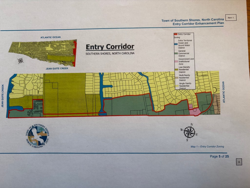
The Committee defines the 1.6-mile-long “corridor” on page 4 of its report as being comprised of:
- 68 acres, or roughly 3.1 percent of the Town’s total land area of 2,175 acres;
- 30 parcels of land; and
- 260,072 square feet of finished commercial floor area
About 93 percent of the corridor is zoned commercial. Four of the 30 parcels are zoned RS-1 low-density single family residential district. (See diagram above.)
Roughly speaking, the Town of Southern Shores has U.S. 158 corridor jurisdiction on the northern side of the highway, and the Town of Kitty Hawk has jurisdiction on the southern side. But there is a shared boundary. This is clarified on page 4 of the report as follows:
“. . . [T]he Town of Southern Shores is located along the northern side of U.S. 158, [but] the entirety of the U.S. 158 right-of-way is actually located within the Town of Kitty Hawk, with the northern edge of the right-of-way serving as the boundary between Southern Shores and Kitty Hawk. The multi-use path, grass and landscaping along U.S. 158 are located within the Town of Kitty Hawk, with their maintenance and use subject to a Memorandum of Understanding between the two towns.”
The rights-of-way of U.S. 158 and N.C. 12, as well as the roads themselves, are under the jurisdiction of the N.C. Dept. of Transportation (NCDOT). To promote the success of the eventual enhancement plan, according to the report, the Corridor Committee “intends to work closely with the Town of Kitty Hawk and NCDOT to ensure coordination and consistency.”
We say “eventual” plan because this Phase One report presents the Corridor Committee’s aspirations, its conceptual thinking, and the data it collected from the survey, the open house, and stakeholder communications, but no recommendations or action items, those being left to Phase Two.
The eventual planning document, the report states on page 2, will serve as a “guiding framework” that will reflect a “shared vision related to the entry corridor and offer direction, inspiration, and tools for decision-making, while leaving flexibility over time.” It apparently will not make suggestions for amending the Town Code to implement its direction and inspiration.
The Committee defines its “Mission Statement” on page 2 as a commitment to:
“revitalizing and unifying the entry corridor along Highway 158. Through evaluation and engagement we seek to establish architectural standards rooted in unified design aesthetics, including landscaping and green spaces and incentivizing diverse development options. We aim to create a cohesive, modern, and community-oriented environment that reflects our heritage and values.”
This strikes us as aspirational planning-speak that cannot truly be evaluated until concrete proposals for change are made later. Metaphorically speaking, the Corridor Committee is framing the premise for the plot of the novel that the Town will write later.
The report breaks the Mission Statement down into seven goals, including to:
- Establish unified architectural standards and district aesthetics;
- Promote biodiverse landscaping and green spaces;
- Support diverse housing incentives;
- Foster community engagement and collaboration;
- Advance economic development aligned with community values;
- Enhance accessibility and connectivity; and
- Implement ongoing review and adaptation
Is the eventual product of the Corridor Committee going to be a statement of policy, not unlike the Town’s Land Use Plan, about desired building style and architecture, signage, landscaping and green space, development uses, and connectivity among the parcels in the corridor?
It appears so. We should learn more about the next steps in Phase Two of the Committee’s planning at Tuesday’s meeting.
By Ann G. Sjoerdsma, The Southern Shores Beacon, 1/25/26