Please read The Outer Banks Voice for an update by Editor Mark Jurkowitz.
According to a Voice article published today, SAGA notified the Town of Southern Shores by email Jan. 26 that it was withdrawing its application and did not cite a reason.
Mr. Jurkowitz interviewed Town Manager Cliff Ogburn and a representative from SAGA for his story, which presumably was prompted by the meeting agenda posted by the Town today. (See our earlier post.)
The Beacon has neither the time nor the staff to do the reporting that The Voice does. We appreciate Mr. Jurkowitz’s update on the application status.
The Beacon, however, did the “heavy lifting” on what happened with the Zoning Text Amendment, enacted by the Town Council last June that opened the door to mixed-use commercial/residential developments in Southern Shores. The Planning Board and the Town Council disagreed on the lot coverage limitation for such building projects.
We strongly believe that the Town should have notified residents of SAGA’s application withdrawal, rather than to leave the impression that the quasi-judicial hearing would be held on Feb. 6, as previously announced.
This is why allegations of a lack of transparency by the Mayor, the Town Council, and the Town Manager arise in Southern Shores.
All of the elected officials and the Town Manager know how passionately invested and interested Southern Shores homeowners have been and still are in SAGA’s permit application, but they did not consider it of compelling or even sufficient public interest to inform homeowners about SAGA’s withdrawal.
We respectfully disagree with their decision. We believe they erred.
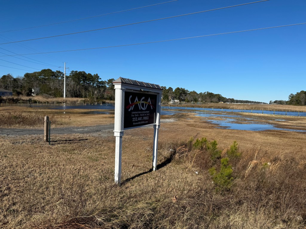
SAGA’s property at 6195 N. Croatan Hwy. experienced flooding after the Jan. 9 storm. (Photo submitted by a Southern Shores resident.)
The quasi-judicial hearing before the Southern Shores Town Council about the Special Use Permit application (SUP 23-01) submitted by a subsidiary of SAGA Realty & Construction for a mixed-use development at 6195 N. Croatan Hwy., on Ginguite Creek, will not be held Tuesday during the Council’s regular monthly meeting, as previously announced.
The Town Council will meet Tuesday at 5:30 p.m. in the Pitts Center, but it will not hear SAGA’s application, according to the meeting agenda released by the Town today.
The Town Council had been scheduled to hear SAGA’s application at its Jan. 9 meeting, but that meeting was canceled because of inclement weather, and the Town announced the hearing would be rescheduled to its Feb. 6 meeting.
Since then, the Town has neither updated its rescheduling announcement nor given the legally required notice for the hearing. It has made no mention of the pending SUP 23-01, which the Planning Board unanimously recommended Nov. 20 be denied.
(For background on the SAGA application hearing, see The Beacon, 1/4/24 and 1/8/24.)
The meeting agenda posted on the Town website today appears routine, featuring the usual staff reports, with the exception of a closed Council session with the Town Attorney that is scheduled amid these reports.
The Town Council will adjourn for its closed session after the Police Chief and Fire Chief have given their December and January reports, but before the Planning Director/Deputy Town Manager and Town Manager give their monthly updates.
There is no indication from the agenda that the Town Manager will be breaking any new ground in his report.
As usual, two public comment periods will be held during the meeting.
The Town Council last met Jan. 16 at 9 a.m. for a mid-monthly meeting whose primary purpose was the holding of a closed session with the Town Attorney, pursuant to N.C. General Statutes sec. 143-318.11(a)(3), which is the attorney-client privilege exception to an open meeting. The agenda cites this same statutory exception for the Council’s closed session Tuesday.
Pursuant to NCGS 143-318.11(a)(3), the Council may close a session with a Town-employed or retained attorney to consult regarding the “handling or settlement of a claim, judicial action, mediation, arbitration, or administrative procedure.”
Mayor Pro Tem Matt Neal presided over the mid-monthly meeting, in Mayor Elizabeth Morey’s absence. The public portion of the meeting lasted less than 15 minutes.
The Southern Shores Town Council sent a “Take Action” email yesterday to residents, encouraging them to oppose what it described as “astronomical” homeowners insurance rate increases recently requested by the N.C. Rate Bureau (NCRB) in one of two public comment forums to be held Monday, from 10 a.m. to 4:30 p.m., or to object to the increases by other means before a Feb. 2 deadline.
The NCRB’s request of the N.C. Dept. of Insurance earlier this month for increases in homeowner insurance rates statewide has aroused considerable alarm locally where the Bureau has asked to raise rates 45.1 percent in the “beach areas” of Dare and Currituck counties and 33.9 percent in the two counties’ “coastal areas.”
These areas are in territories 110 and 130, respectively, in the NCRB’s rating system, which uses such factors as population density and loss experience to divide North Carolina territorially.
The NCRB represents companies that write insurance policies in the state. It has asked the Dept. of Insurance for an average statewide increase in homeowner insurance rates of 42.2 percent, claiming that the insurance industry is losing money in paying off claims.
The NCRB’s highest requested rate increases are concentrated in the southern coastal area of North Carolina. It has asked for increases in homeowner insurance rates of 99.4 percent for the beach areas of Brunswick (Bald Head Island, Holden Beach), Carteret (Atlantic Beach, Emerald Isle, Morehead City), New Hanover (Carolina Beach, Wilmington), Onslow and Pender counties (territory 120) and 71.4 percent in the “eastern coastal areas” of these counties, as well as in a long list of eastern coastal area zip codes (territory 140).
A public-comment period is required by law before the Dept. of Insurance can take action on the requested rate increases. Monday’s all-day public forums will be held in a hearing room in Raleigh and, simultaneously, in a virtual hearing.
You also may email public comments to 2024homeowners@ncdoi.gov or write to the Dept. of Insurance c/o Kimberly W. Pearce, Paralegal III, 1201 Mail Service Center, Raleigh, NC 27699-1201. Comments sent by email or regular mail must be received by Feb. 2.
In its “Take Action” email, the Town Council said it “strongly opposes these astronomical homeowners insurance rate increases, which, if implemented, would make homeownership unattainable for many first-time buyers and be extremely difficult for current homeowners to afford—particularly Dare County’s teachers, first responders, medical personnel, government employees and service industry staff, among many others. Many homeowners will opt for higher deductibles in order to avoid the exorbitant insurance premiums. This will result in homeowners receiving smaller insurance claim payments, which will directly impact their ability to recover from storm damage or other disaster events.”
Among the points offered by the OBAR is the following: “N.C. law states that insurance rates shall not be excessive, inadequate, or unfairly discriminatory. It is implausible that the requested rates can be determined to be anything other than excessive.”
The NCRB does not have the authority to regulate insurance rates or to require insurance companies to adopt the rates it files. The Dept. of Insurance is solely responsible for regulating insurance rates in North Carolina.
If Insurance Commissioner Causey does not agree with the NCRB’s requested rates—and he likely will not—he can deny them or negotiate them with the Bureau. If the Department and the Bureau cannot reach a settlement within 50 days, the Commissioner will call for a hearing.
Mr. McGrath expounds upon how climate change and the rising value of coastal property influenced the Rate Bureau’s request and concludes that, if history is any guide, the parties will settle on rate increases that are much less than the industry wants and much higher than homeowners think they should bear.
The NCRB has asked that its requested rate increases take effect Aug. 1.
Ann G. Sjoerdsma, 1/20/24
(We continue to have problems preserving graphics links between the website and the Beacon’s Facebook page, for which we apologize.)
Citing a forecast of severe weather, the Town of Southern Shores has canceled the quasi-judicial hearing scheduled tomorrow at 5:30 p.m. before the Town Council on the special use permit application (SUP 23-01) submitted by Ginguite, LLC, a subsidiary of SAGA Realty & Construction, for a mixed-use group development of luxury condominiums, retail shops, restaurants, and offices at 6195 N. Croatan Hwy. (U.S. Hwy. 158).
The hearing has been rescheduled to Feb. 6, when the Town Council will hold its next regular monthly meeting, according to a Town announcement posted online late this afternoon.
(See The Beacon, 1/4/24, for a preview of the hearing.)
DARE STUDENTS HAVE REMOTE LEARNING DAY TOMORROW
Earlier today, the Dare County Schools announced that tomorrow will be a Remote Learning Day for students and an Early Dismissal Day for staff members because of predicted storm conditions. Staff members are to report for work in the morning.
The Superintendent’s Office will decide at noon tomorrow whether to alter school hours on Wednesday.
Storm conditions forecasted to start tomorrow afternoon are expected to continue into Wednesday.
Weather Forecast: Dare County is already under a Coastal Flood Warning and High Wind Warning, according to the National Weather Service. A cold front with strong winds that is arriving in our area tomorrow is expected to cause both soundside and ocean flooding.
The storm event tomorrow will principally pose a wind threat, according to the NWS, with the high temperature in the mid- to upper-50s. Conditions are expected to worsen tomorrow evening as rain and wind velocity increase and temperature declines.
A roadside view of Ginguite LLC’s property at 6195 N. Croatan Hwy. in its current natural state.
The Southern Shores Town Council will hold a quasi-judicial hearing on the special use permit application (SUP 23-01) submitted by Ginguite, LLC, a subsidiary of SAGA Realty & Construction, for a mixed-use group development of luxury condominiums, retail shops, restaurants, and offices at 6195 N. Croatan Hwy. (U.S. Hwy. 158), on Ginguite Creek, Tuesday at 5:30 p.m. in the Pitts Center.
The Town Council is dedicating its first regular meeting of year to the hearing, according to the agenda posted on the Town website. No other business is scheduled.
The Town Planning Board voted unanimously Nov. 20 to recommend a denial of Ginguite’s SUP 23-01. It reached a decision after devoting three lengthy monthly meetings last fall to a review of the application, all of which were attended by a vocal crowd of opponents from both Southern Shores and the larger Outer Banks community.
(See The Beacon, 11/20/23, as well as articles posted 9/19/23 and 9/29/23 and in October 2023.)
Ginguite proposes to build two three-story wood-framed buildings, 200 parking spaces, and associated infrastructure on what it represents is about 4.55 acres of a 6.96-acre property that is zoned predominantly commercial, with a small section of R-1 low-density residential in the northern end.
Ginguite withdrew its plan to have a marina on the site when the Town advised it that marinas are not a permissible use of the property under the Town Code.
Thirty-six multi-family residences would be constructed, 30 in an exclusively residential building and six in a building that also would house retail shops, offices, and restaurants, according to Sumit Gupta, Co-Founder, Partner, and Chief Executive Officer of SAGA, who has served as Ginguite’s representative since early 2022 when he first started publicly promoting the mixed-use project.
While the Town Council often defers to the Planning Board’s recommendations, it is not bound by them. The Council will make its own factual determinations and exercise its own discretion in reaching a conclusion Tuesday on Ginguite’s application.
A quasi-judicial hearing is similar to a court proceeding. Rules of evidence are observed, and only sworn, factual testimony by parties to the hearing (Ginguite and the Town of Southern Shores) or the witnesses they call may be presented. Such hearings protect the due process rights of the party or parties seeking the municipal administrative action at issue.
The public will have an opportunity to comment before and after the hearing. (See below.)
BACKGROUND ON MIXED-USE ZONING IN TOWN
Ginguite is seeking a permit for the first-ever residential/commercial use (mixed-use) group development in Southern Shores. It cannot apply to the Town for a building permit until it receives a special use permit and meets any conditions that the Town may impose in it.
The Town Council authorized mixed-use group development zoning on June 7, 2022, when it held a public hearing on Zoning Text Amendment (ZTA) 22-06 and unanimously voted to enact an amended version of the ZTA, which Ginguite first proposed in a sketchy form in February 2022.
ZTA 22-06 added a “mixed-use group development of commercial and residential buildings” as a conditional or “special use” in the C general commercial district and specified the requirements for such developments. (See the amendment at Town Code 36-207(c)(11).)
The Planning Board met publicly over a period of months in early 2022 with Mr. Gupta, cautiously considering how to support, yet regulate, mixed-use zoning, before it voted, 4-1, to recommend 1) denial of the ZTA presented by Mr. Gupta, which it viewed as insufficient, and 2) approval of its own version of the ZTA, labeled PB-ZTA 22-06. The Board’s ZTA included lot-coverage restrictions. Both ZTAs went to the Town Council for a hearing.
The Town Council approved a version of the ZTA promoted by Mayor Elizabeth Morey and Mayor Pro Tem Matt Neal that incorporated all of the language of PB-ZTA 22-06, except the Planning Board’s lot coverage restrictions. The Mayor opened discussions by framing the two choices that the Council had on lot coverage, neither of which was what the Planning Board had recommended. (See The Beacon, 6/10/22 and 6/20/22 for background and analysis.)
Four of the five current Town Council members—the exception being newly elected Councilman Robert Neilsen—supported the revised ZTA proposed by Mayor Morey and Mayor Pro Tem Neal, as well as the design plan for the Ginguite Creek project that Mr. Gupta presented, even though the ZTA was not site-specific.
There is no doubt from the public record that the Town Council enacted ZTA 22-06 with the SAGA/Ginguite project specifically in mind.
As The Beacon previously reported, Mayor Morey, Mayor Pro Tem Neal, and Town Manager Cliff Ogburn met privately with Mr. Gupta on the morning that the Council held the public hearing on ZTA 22-06 and took its vote. The Beacon’s source on this meeting is the mayor herself.
Mr. Gupta stated during meetings with the Planning Board that he earlier had met with Planning Director/Deputy Town Manager Wes Haskett and other “Town officials” to negotiate the mixed-use ZTA. The Town shepherded both this ZTA and this project.
There was no public opposition during the Planning Board’s months of meeting publicly with Mr. Gupta to discuss ZTA 22-06. This period coincided with a time when The Beacon was on winter hiatus.
We believe that legitimate questions can be raised about the review process of ZTA 22-06, both before the Planning Board and the Town Council. An argument can be made that the Planning Board should have had another round of review of the ZTA after it made amendments to Ginguite’s version, i.e., it created PB-ZTA 22-06, and the Town Council should have sent its own amended version of the ZTA back to the Planning Board for consideration before it voted.
The Town Attorney advised the Town Council that it could proceed with a vote.
The public would have been given notice and an opportunity to be heard at additional reviews of the revised ordinance.
PLANNING BOARD’S RECOMMENDATION OF DENIAL OF SUP
The Town Planning Board based its unanimous decision Nov. 20 to recommend a denial of Ginguite’s application principally on the allegedly deplorable state of the on-site wastewater treatment plant that currently serves the Southern Shores Landing, Ginguite’s neighbor to the east, and would serve the new development.
The Gupta family owns the wastewater treatment plant, which has been operated on an emergency basis since 2009 because of regulatory noncompliance. We are not aware of any action that the Guptas may have taken since Nov. 20 to correct the plant’s deficiencies.
Planning Board Member Ed Lawler painstakingly went through documentation that he had obtained from online research into the websites of the N.C. Dept. of Environmental Quality and the N.C. Utilities Commission to show the dysfunctionality of the plant, detailing numerous violations for which the owners have been cited.
“There is no treatment occurring there,” said Mr. Lawler, who noted that “the water never gets to the area where it should go,” going instead into an infiltration pond.
The Planning Board also sought a 50-foot side-yard setback between Ginguite’s proposed development and the boundary line with the Southern Shores Landing (SSL).
Although SAGA expanded its original 15-foot side-yard setbacks with the SSL community to setbacks that varied along the boundary from 20 feet to 34 feet, the developer said it could not accommodate wider setbacks. Mr. Gupta argued that because the Landing is commercially zoned, Ginguite is not required by the Town Code to preserve more than a 15-foot setback.
Southern Shores residents turned out at every Planning Board meeting review of SUP 23-01 to express often impassioned opposition to the SAGA project. After the Board voted to deny the SUP, applause broke out in the audience.
A strong public turnout is expected Tuesday.
People who wish to comment about the proposed SAGA project and/or the requested SUP will be able to do so during two periods devoted to public comment, one scheduled before the quasi-judicial hearing and one after. Speakers must limit their remarks to three minutes. There will be sign-up sheets in the rear of the Pitts Center meeting room for those who wish to speak.
The Southern Shores Town Council received at its Dec. 5 meeting the first beach nourishment monitoring report from its coastal-engineering partner, Ken Willson of Coastal Protection & Engineering (CPE), and it was an extremely positive one—so much so that Mr. Willson suggested the Town may not have to re-nourish the beaches in five years (2027), a standard “maintenance” cycle that Dare County encourages.
After hearing this good news, Town Council members appeared quick to evaluate the October-November 2022 beach nourishment project as “successful.” But the question to ask in assessing the Town’s first-year beach report is not whether the project was “successful” or not.
Project construction occurred as planned: The sand was placed according to the project design. That would seem to constitute a success.
No, the question to ask is one that Mr. Willson himself posed in presenting the results of the first project monitoring report: “Did we need beach nourishment in the first place?”
Based on the data provided by Mr. Willson, which show a “positive” three-year gain of sand volume on the entire Southern Shores coastline without nourishment, one can argue—as we argued 3 1/2 years ago—that it was not.
According to Mr. Willson, between November 2022 and June 2023, when CPE surveyed its 23 beach profile stations, which are 1,000 feet apart, along Southern Shores’ 3.7-mile-long coastline, the system gained nearly 400,000 cubic yards of sand: That is in addition to the sand that was placed by the project itself.
One might say that the beaches nourished themselves, as they often do.
CPE based its beach nourishment project on station data from 2020. Conditions look different now.
ALL SECTIONS GAINED SAND WITHOUT NOURISHMENT
As you undoubtedly remember, CPE divides the Southern Shores shoreline into three sections for purposes of its surveying and planning. They are:
The Southern Section, whichextends from the Kitty Hawk town line to 500 feet south of Chicahauk Trail.
The Central Section, whichextends from 500 feet south of Chicahauk Trail to 4th Avenue.
The Northern Section, which extends from 4th Avenue north to the Duck town line and was only included in the beach-nourishment area after former Mayor Tom Bennett added the goal of “maintaining a sufficiently useable beach” to the project, and the then-Town Council, which included newly sworn-in members Elizabeth Morey and Matt Neal, the current mayor and mayor pro tem, unanimously supported him.
Mayor Bennett sought to accommodate two very vocal and assertive 7th Avenue homeowners who, armed with visual aids during their many appearances before the Town Council in 2019, objected to having their oceanfront excluded from the project.
Before Dec. 3, 2019, when the Council voted to expand the project, it had only two goals: 1) reduce damage from potential future storms, i.e., protect the beaches in the event of a theoretical major storm; and 2) mitigate long-term erosion.
Mr. Willson refers to the first goal as a “vulnerability assessment.” Through the use of a storm-simulation computer model, CPE—known at the time as APTIM—calculated how much sand would have to be put on the Southern Shores beaches in order to reduce potential storm damage from a potential storm comparable to Hurricane Isabel.
Isabel hit Dare County in 2003, but as Spencer Rogers, a noted North Carolina coastal engineer and erosion specialist, told The Beacon in 2020, it “pretty much petered out by the time it got to Kitty Hawk.”
“Storm patterns are pretty scattered” in the northern Outer Banks, in contrast to Hatteras Island and the southern Outer Banks, Dr. Rogers said, adding that nor’easters, which occur in the fall through the late spring, are a bigger threat to Southern Shores than hurricanes.
Southern Shores has a history of low long-term average erosion rates. These rates are obtainable from the N.C. Division of Coastal Management, and we have previously examined them.
CPE looked at some data from October 2006, when the U.S. Army Corps of Engineers Field Research Facility north of Duck collected measurements on the southern 15,000 feet of the Southern Shores shoreline, roughly from 3rd Avenue south to the Kitty Hawk line.
CPE did not explain FRF’s data-collection methodology, so we could not know whether a comparison of the 2020 data with the 2006 data was even valid. But, in any case, it was just a snapshot of beach conditions in 2006, just as every survey of the beach profile since December 2017, when CPE/APTIM conducted its first, is another snapshot of conditions at the time in which it is done.
On 1/26/2021, we wrote: “A series of beach snapshots taken over an extended period of time—during the same month each year—eventually will yield a useful portrait of Southern Shores’ ever-changing 3.7-mile-long shoreline. But we are not there yet.”
The new CPE report bears out this proposition.
SAND INCREASES SPIKED IN THE YEAR BEFORE THE PROJECT
In a telltale graph titled “Project Performance Update—South of 4th Avenue” and shown by Mr. Willson in his Powerpoint presentation to the Council, the volume of sand in the Northern Section is shown as steadily increasing since late 2017, when the Pelican Watch/Kitty Hawk Pier beach area was nourished, and then spiking in the year before the 2022 project.
During the same time, the sand volume in the Central Section steadily increased from 2017, then dipped off in June 2020 and leveled off—not gaining or losing volume—until it spiked a year before the 2022 project.
Even the sand volume in the Southern Section, which is the most erosion-prone area of the beaches, reversed in June 2020 a three-year decline, steadily increasing until it spiked at the same time as the Northern and Central Sections.
(You will find the graph at about the 59-minute mark of the You Tube meeting video and on p. 21 of Mr. Willson’s draft report.)
Mr. Willson also shared numbers showing just what these increases, which represent natural accretions of sand, amounted to:
—The Southern Section added 97,900 cubic yards of sand. This is in addition to the 343,700 cubic yards placed in the 2022 project.
—The Central Section gained 140,600 cubic yards of sand, in addition to 580,800 cubic yards placed by the project.
—The Northern Section accreted by 161,400 cubic yards of sand, in addition to 124,000 cubic yards placed by the project.
Overall, he said, the beaches gained 1,048,400 cubic yards of sand.
In another slide, Mr. Willson showed that the sand volume change rates in the three sections between 1) November 2022 to June 2023, and 2) December 2017 to August 2022, which was just before project construction, were as follows:
—In the Northern Section, 35.5 cubic yards per foot per year, and 5.3 cy/ft/yr over the five-year period.
—In the Central Section, 12.8 cubic yards per foot per year, and 0.4 cy/ft/yr over the five years.
—In the Southern Section, 17.6 cubic yards per foot per year, and 0.1 cy/ft/yr over the five years.
The average volume change rate from November 2022 to June 2023 year was 20.9 cy/ft/yr; in the five-year period before the project, it was 2.0 cy/ft/yr.
Cy/ft/yr represents a density measurement. It means that for every foot of coastline, there is a net change of a certain number of cubic yards of sediment—both what is visible and what is off-shore.
THE BEACON ARGUED FOR POSTPONING THE PROJECT
Indeed, the ebb and flow of sand in the Southern Shores beach system—of natural erosion and accretion—is exactly what we argued more than three years ago in maintaining that our beaches have always been stable and did not need sand fill except perhaps in the vulnerable southern end.
We read and analyzed all of CPE’s beach studies, obtained historic erosion data, and interviewed experts in order to understand the coastal environment better. On 6/15/20, the day before the Town Counil held a public forum on beach nourishment, we published our argument against there being a “need” for the project.
The Council disagreed, however, and voted unanimously to “pursue” beach nourishment, deciding the specifics of the project later in the year. Mr. Neal led the way.
Subsequently, on 1/26/221, we wrote an informative “Special Report,” in which we analyzed CPE’s 2020 short-term beach data, which came in after the Council’s decision; explained the basics of beach nourishment; and offered “How the Beach Works 101.”
A fundamental principle of this introductory course is that change is the only constant. The coastal environment is dynamic, filled with energy and constantly changing.
Even Mayor Bennett considered reversing course in February 2021, suggesting that the scope of the project should not include the Northern Section because the 2020 survey had shown that it gained sand and was not in “critical need.” That survey also showed that the Central Section had neither gained nor lost sand. Only the Southern Section had lost sand. (See The Beacon, 2/5/21.)
We would have waited another five years and collected more beach survey data before we gave beach nourishment the go-ahead, and we said so, repeatedly. Results like Mr. Willson presented on Dec. 5 reinforce our perspective and our strategy. But we were in a minority.
We hope that as CPE’s survey data accumulate, a picture of the shifting Southern Shores shoreline will start to emerge for the Town Council to see.
“IT DOESN’T LOOK LIKE CONDITIONS ARE GETTING BETTER”
So how does Ken Willson answer his own question? Was the beach nourishment project justified? Should the project have been done “in the first place”?
His answer: “It certainly doesn’t look like conditions are getting better out there. We know sea level is rising. We know sand is being eroded away.”
But everyone who knows anything about a beach profile—and Mr. Willson knows a lot—knows that most of the sand is not visible to the naked eye. Most of it is under water, extending out to what is known as the depth of closure.
The dry-sand beach that we see and walk upon represents only a “fraction” of the active beach “profile,” Mr. Willson wrote in a 2017 white paper for the American Shore & Beach Preservation Assn.
The “profile” is the area from the landward dunes and vegetation line east to what is known as the “depth of closure,” the seaward boundary.
The depth of closure is just beyond where the largest waves break; it is usually 15 to 25 feet beneath the ocean.
According to Dr. Rogers, of UNC-Wilmington’s Center for Marine Science, whom we interviewed extensively in 2020, “It is very difficult to eyeball the shoreline” and assess its status, which, of course, is what laypeople tend to do. (Dr. Rogers retired in 2022.)
Not only is much of the beach profile under water, there are “radical changes” going on in the dry-sand area that the eye cannot detect, he said.
Nonetheless, Mr. Willson said, “The project was absolutely warranted,” based on the “vulnerability analysis,” which was conducted with the theoretical storm-model computer methodology we mentioned above (Isabel), and “previous trends showing erosion rates.”
As early as September 2019, two oceanographers from the Field Research Facility, who live in Southern Shores, questioned beach-nourishment recommendations made by APTIM/CPE.
They advised the Town Council at its monthly September meeting more than four years ago that APTIM/CPE’s recommendations were “based on limited data” and “on short-term trends that are not particularly helpful.” (See The Beacon, 9/20/19)
They were ignored by a majority of the Bennett-led Town Council. As more data came in about the state of the Southern Shores beaches, Mayor Bennett questioned the “scope” of a beach nourishment project, but the Town Council never seriously re-thought going ahead, and did so under Mayor Morey.
Southern Shores property owners town-wide were split on whether to endorse a project, Mr. Neal told us after the public forum, but oceanfront property owners overwhelmingly supported it.
“Maybe,” Mr. Willson said in analyzing the “positive” results of CPE’s monitoring, the idea of doing a beach nourishment project every five years—as has been the expectation for all Dare County-funded projects—“gets extended,” so the next project is six, seven years, or longer from now.
The “trend” toward accretion may continue, but then there is likely to be erosion again. That’s been the nature of the coastal environment. Ebb and flow.
SHORELINE CHANGES ALONG THE COASTLINE
To be thorough, we include here the shoreline change rates reported by Mr. Willson on Southern Shores’ beaches during the period from November 2022 to June 2023 and in the five-year period from December 2017 to August 2022.
The “bar” for measuring shoreline change is the mean high-water (MHW) mark on the dry-sand beach. If the MHW moves landward, there is a negative shoreline change; seaward movement connotes a positive change.
In the Northern Section, the shoreline change from 2022-23 was 11.8 cy/ft/yr; in the five-year period, it was 0.8 cy/ft/yr.
In the Central Section, the shoreline change from 2022-23 was -45.5 cy/ft/yr; in the five-year period, it was -4.0 cy/ft/yr.
In the Southern Section, the shoreline change from 2022-23 was -9.4 cy/ft/yr; in the five-year period, it was -3.4 cy/ft/yr.
An anticipated loss of sand placed by the project—which is known as advance fill—accounts for the large change numbers in the Central and Southern sections in the past year, Mr. Willson explained. That sand has migrated off-shore; it hasn’t left the profile.
The next beach monitoring survey will be done in May or June, Mr. Willson said. We look forward to the results.
In light of the tremendous interest The Beacon blog post yesterday about the Chicahauk Property Owners Assn. meeting at 5:30 p.m. today received—and the contact we received from readers saying that property owners have not been informed about it—we contacted CPOA president David Stager this morning and officially confirmed the meeting, which will be held in the Pitts Center.
According to Mr. Stager, the purpose of the meeting is to “gather” questions for a survey to be sent to CPOA members regarding whether to “change or adjust” association covenants. (See yesterday’s Beacon post.)
Mr. Stager said a member of the CPOA Board of Directors is holding the meeting, but he declined to identify who the board member is.
The Beacon has learned from other reliable sources, who prefer to remain anonymous, that the Board members behind the meeting are James Krueger and Maureen McGovern.
The Southern Shores Beacon was founded in April 2018 in order to better inform property owners of news in Southern Shores so that they may knowledgeably participate in community conversations. We believe everyone should have a voice in local decision-making. Our sole purpose in publicizing the CPOA meeting is to inform.
Did you know that guest houses, “ancillary” guest suites, and accessory structures may not be leased or rented separately from the main single-family residence on a lot in Chicahauk?
Or that duplexes and multiple-family houses are “expressly prohibited” in this subdivision of Southern Shores, which is subject to the Town Code as well as its own governing rules?
Or how about that no “existing vegetation or sand dunes shall be disturbed, removed or destroyed during construction” unless the Chicahauk Property Owners Assn. (CPOA) gives “express written consent” for such disturbance/removal/destruction to occur?
We are quoting from provisions of Article III of the Chicahauk covenants, as adopted on June 8, 2010 by the CPOA, that plainly prohibit Airbnb and other room/suite/guest house rentals and clear-cutting of lots, as well as less extensive vegetation changes, in the subdivision.
And yet, we all know that such rentals exist in Chicahauk and that homeowners there clear-cut their lots and otherwise “disturb” vegetation during construction without obtaining permission first from the property owners’ association.
What other mandates is the CPOA Board of Directors ignoring? Is its benign neglect what other property owners want?
Do the CPOA covenants need enforcement or revision and updating?
If you live in Chicahauk, you might wish to attend a CPOA meeting tomorrow at 5:30 p.m. in the Pitts Center to discuss a review of the CPOA covenants and bylaws and contribute your thoughts to answering these questions.
(We received word earlier today from CPOA members that the meeting was being held, but they did not identify a presiding committee. Notice of a meeting does not appear on the CPOA website.)
According to our sources, the CPOA will scrutinize the covenants and bylaws, which were last revised on Dec. 6, 2012, and discuss the drafting of a survey to solicit opinions from the membership about possible changes.
If you participate in a community conversation now, you won’t be surprised later.
BEACH NOURISHMENT ASSESSMENT
We regret that we have not had the time or opportunity to report on the update given by Ken Willson of Coastal Protection Engineering at last Tuesday’s Town Council meeting on the status of the Southern Shores beaches.
According to Mr. Willson, CPE surveyed the beaches at its 23 station profiles in late November 2022, after the October-November beach nourishment project, and in June 2023. He generally gave a positive assessment, saying that, even without the sand volume added by the nourishment, the beaches would have gained volume through natural accretion.
Mr. Willson suggested that the Town might not have to maintain its beach nourishment on a five-year cycle, being able to extend out six or seven years before the next project will have to be done.
We would like to give you data from Mr. Willson’s report to back up this overview and will do so as soon as possible.
PLANNING BOARD/BOA MEETING DEC. 18: A Variance Request and Lot-Width ZTA
The Southern Shores Planning Board will sit as the Board of Adjustment next Monday at 5 p.m. in the Pitts Center to hear a request from the owner of 17 Ninth Ave. for a variance that would allow him to locate a 10-foot-by-16-foot shed in the minimally required side-yard setback, as set forth in Town Code sec. 36-202(d)(4).
A side-yard setback of 15 feet is required in the RS-1 single-family residential district between a building and all structures that are at least 30 inches tall and the side boundary line of an adjacent property. If the edge of property owner Gerald Soucy’s shed is closer than 15 feet to the side-lot line, he has violated the ordinance.
In his variance application, Mr. Soucy writes that the shed is five feet “from the side-yard fence.” But he points out that the shed is more than 30 feet from the neighbors’ pool fence and more than 45 feet from their house.
“These distances are in line with the spirit of the setback ordinance,” he writes, if not the letter of it.
Board of Adjustment hearings on variances are quasi-judicial, not legislative public hearings. Members of the public may give factual testimony under oath—not opinions—only if they could be aggrieved by the Board’s decision on the variance application, which is VA-23-02.
According to instructions by the Town, only “immediate neighbors” whose “property use, enjoyment and value would be adversely impacted by the Board’s decision” can be considered “aggrieved.”
The variance application may be found in the supporting documents appended to the Planning Board meeting notice at:
Also on the Board’s agenda for Monday is consideration of a Zoning Text Amendment, ZTA 23-05, that rewrites, and presumably clarifies, the language of ordinances pertaining to the minimally required lot widths in the Town’s residential zoning districts.
By a vote of 3-2, the Town Council enacted a “stopgap” ordinance on lot width at its June 6 meeting that enabled only those lots newly created by subdivision or recombination that have uniform minimally required widths from side-lot-line to side-lot-line, to be considered conforming. Thus, in the RS-1 single-family dwelling district, a new lot would have to be 100 feet in width throughout. No irregularly shaped lots would be conforming, only rectangular ones.
Mayor Pro Tem Matt Neal and Councilwoman Paula Sherlock objected to the stopgap ordinance, ZTA 23-03, arguing that it mandated too many Town Code amendments and that the “ambiguity” it sought to resolve, according to Mr. Neal, “was where the front setback is.”
The front building setback line was and is used as a measuring stick for lot width.
“Wouldn’t it be simpler,” Mr. Neal asked, “to fix the front setback at one static location?”
We answered “yes” to him in our blog post of 6/13/23 and are not surprised that the new ZTA, 23-05, develops this concept–with one big wrinkle.
In fixing the front building setback line, at which lot width is to be measured, the new ZTA distinguishes between lots that front on a cul de sac from all other lots.
For example, in the RS-1 district, the building setback line may be established up to 80 feet from the front lot line of cul-de-sac lots, whereas the building setback line for all other lots shall be established 25 feet from the front lot line.
We find the language for where the 100-foot width is to be measured on lots that front on cul de sacs to be problematic and expect it to give the Planning Board pause.
Planning Director/Deputy Town Manager Wes Haskett recommends approval of ZTA 23-05 in his staff report. Both Mr. Haskett’s report and the ZTA may be found in the supporting documents, as cited above.
How have the beaches fared since last year’s nourishment project? We’ll find out Tuesday.
Town Council members Matt Neal and Mark Batenic, who were re-elected in the Nov. 7 election, and newcomer Robert Neilson will be sworn into office for their four-year terms, and the Town Council will elect a mayor pro tempore and make Dare County and regional council committee appointments, at its meeting Tuesday, at 5:30 p.m., in the Pitts Center.
The Town Council also will recognize outgoing Councilman Leo Holland, who served eight years in two non-consecutive terms, for his service. Mr. Holland has been Southern Shores’ representative on the Dare County Tourism Board of Directors during his tenure.
In other business, Ken Willson of Coastal Protection Engineering will present the results from the first survey of the Southern Shores beaches since the October-November 2022 beach-nourishment project, and the Council will discuss renovations to the Town-owned flat top at 13 Skyline Road that are needed to convert the historic building back into a residence, which will be used on a temporary basis by newly hired police officers.
The flat top most recently served as headquarters for the Outer Banks Community Foundation, which moved its offices to Manteo.
As of the close of business Friday, Mr. Willson had not filed his draft report of CPE’s beach nourishment monitoring with the Town. If the report is posted before Tuesday’s meeting, we will preview the results.
A list of items deemed necessary by Town staff to renovate the Skyline Road flat top (e.g., carpeting/flooring, roof repair, plumbing, washer/dryer, kitchen supplies, etc.) is included in the meeting packet. These items total $14,890. The staff also prepared a contingency list for furniture that totals $21,150.
Town staff is requesting approval from the Town Council of a 2023-24 budget amendment in the amount of $36,150 to cover $21,150 in flat-top renovations and $15,000 in other costs, including $450 in annual water charges, $1,200 in annual electricity charges, $528 in pest control, and $11,669 in legal fees.
The Town Council’s regular December meeting after a municipal election is always an organizational meeting for the reconstituted governing board, during which the election of the mayor pro tem, who serves as mayor when the mayor is absent or incapacitated physically or mentally, is the paramount task. Mr. Neal has served as mayor pro tem during the past two years.
The Council also will appoint or nominate people to serve on the Dare County Gov-Ed Access Channel Committee, the Albemarle Rural Planning Organization, and the Dare County Tourism Board and approve its 2024 meeting schedule.
The Council’s first meeting in 2024 is scheduled Jan. 9 at 5:30 p.m.
NEW POLICE RECRUIT POSITION
At its Nov. 14 meeting, the Town Council unanimously approved Police Chief David Kole’s request to create a “Recruit” position in his department, enabling him to hire a full-time employee whom the Town would pay to attend and successfully complete the 16-week N.C. Basic Law Enforcement Training Academy (BLET) offered at the College of the Albemarle.
Chief Kole estimated the cost of the BLET training at $2800 to $3000.
According to the Police Chief, the Recruit would initially receive a salary “25 percent below the base starting pay for a fully qualified police office.” Upon meeting all of the qualifications for a police officer, the Recruit would be sworn into office, promoted to the appropriate pay grade, and serve on a probationary basis for one year.
According to a draft contract between the Recruit and the Town, a copy of which was included in the Nov. 14 meeting packet, the Town would “recoup” some of its financial investment in the Recruit in the event he or she does not fulfill his/her obligations—and other specific conditions are met—for up to three years from the date of hiring.
This unprecedented hiring method is an attempt by Chief Kole to fill one of three officer vacancies he has had for the past 2 ½ years with someone he believes would fit in with his department and the community, he told the Town Council.
“I could have filled these [three] slots six months ago,” he said at the meeting last month, “but we don’t want just anybody.”
When asked by Mayor Elizabeth Morey what other Outer Banks municipalities might have done or be doing to fill police vacancies, which the Police Chief has said exist largely because of the lack of affordable housing available, he replied that the Dare County Sheriff’s Department had recruited trainees, but he did not comment on nearby towns’ efforts.
A search of the Duck, Kitty Hawk, Kill Devil Hills, Nags Head, and Manteo websites reveals that Kitty Hawk, Kill Devil Hills, and Nags Head each have one vacancy for a police officer, and Manteo is seeking a police chief. Duck has no openings.
Chief Kole told the Town Council that he has identified a qualified candidate who “was born and raised in Currituck County” and has ridden along with other officers on their patrols. If hired, the candidate would begin his police training in January.
In light of the lengthy vacancy time of the three police officer positions, it seems logical for the Town Council to ask whether the Town actually needs to hire more officers. The Police Department seems to have operated well without the additional personnel.
The Town Council did not discuss a timetable for renovation and occupancy of the Skyline Road flat top or settle upon a lease term and monthly rent for the residence.
New Duck Road Sidewalk and Friday Night Power Outage: ALSO LAST MONTH, Town Manager Cliff Ogburn advised that the new east-side Duck Road (N.C. Hwy. 12) sidewalk will be finished by the end of March 2024 and confirmed that the three-hour power outage on Friday, Nov. 3, was caused by fiber cable installer Ripple knocking out three major power lines. More than 2200 houses were in the dark, Mr. Ogburn said.