The Southern Shores Town Council received at its Dec. 5 meeting the first beach nourishment monitoring report from its coastal-engineering partner, Ken Willson of Coastal Protection & Engineering (CPE), and it was an extremely positive one—so much so that Mr. Willson suggested the Town may not have to re-nourish the beaches in five years (2027), a standard “maintenance” cycle that Dare County encourages.
After hearing this good news, Town Council members appeared quick to evaluate the October-November 2022 beach nourishment project as “successful.” But the question to ask in assessing the Town’s first-year beach report is not whether the project was “successful” or not.
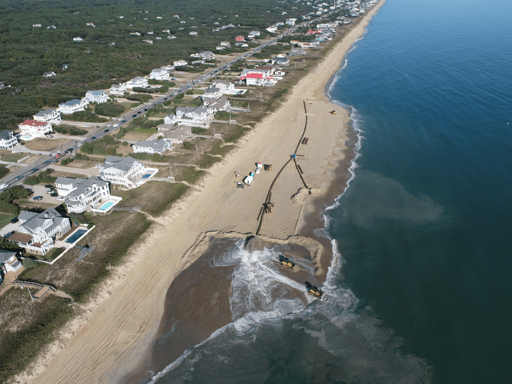
Project construction occurred as planned: The sand was placed according to the project design. That would seem to constitute a success.
No, the question to ask is one that Mr. Willson himself posed in presenting the results of the first project monitoring report: “Did we need beach nourishment in the first place?”
Based on the data provided by Mr. Willson, which show a “positive” three-year gain of sand volume on the entire Southern Shores coastline without nourishment, one can argue—as we argued 3 1/2 years ago—that it was not.
According to Mr. Willson, between November 2022 and June 2023, when CPE surveyed its 23 beach profile stations, which are 1,000 feet apart, along Southern Shores’ 3.7-mile-long coastline, the system gained nearly 400,000 cubic yards of sand: That is in addition to the sand that was placed by the project itself.
One might say that the beaches nourished themselves, as they often do.
CPE based its beach nourishment project on station data from 2020. Conditions look different now.
ALL SECTIONS GAINED SAND WITHOUT NOURISHMENT
As you undoubtedly remember, CPE divides the Southern Shores shoreline into three sections for purposes of its surveying and planning. They are:
The Southern Section, whichextends from the Kitty Hawk town line to 500 feet south of Chicahauk Trail.
The Central Section, whichextends from 500 feet south of Chicahauk Trail to 4th Avenue.
The Northern Section, which extends from 4th Avenue north to the Duck town line and was only included in the beach-nourishment area after former Mayor Tom Bennett added the goal of “maintaining a sufficiently useable beach” to the project, and the then-Town Council, which included newly sworn-in members Elizabeth Morey and Matt Neal, the current mayor and mayor pro tem, unanimously supported him.
Mayor Bennett sought to accommodate two very vocal and assertive 7th Avenue homeowners who, armed with visual aids during their many appearances before the Town Council in 2019, objected to having their oceanfront excluded from the project.
Before Dec. 3, 2019, when the Council voted to expand the project, it had only two goals: 1) reduce damage from potential future storms, i.e., protect the beaches in the event of a theoretical major storm; and 2) mitigate long-term erosion.
Mr. Willson refers to the first goal as a “vulnerability assessment.” Through the use of a storm-simulation computer model, CPE—known at the time as APTIM—calculated how much sand would have to be put on the Southern Shores beaches in order to reduce potential storm damage from a potential storm comparable to Hurricane Isabel.
Isabel hit Dare County in 2003, but as Spencer Rogers, a noted North Carolina coastal engineer and erosion specialist, told The Beacon in 2020, it “pretty much petered out by the time it got to Kitty Hawk.”
“Storm patterns are pretty scattered” in the northern Outer Banks, in contrast to Hatteras Island and the southern Outer Banks, Dr. Rogers said, adding that nor’easters, which occur in the fall through the late spring, are a bigger threat to Southern Shores than hurricanes.
Southern Shores has a history of low long-term average erosion rates. These rates are obtainable from the N.C. Division of Coastal Management, and we have previously examined them.
CPE looked at some data from October 2006, when the U.S. Army Corps of Engineers Field Research Facility north of Duck collected measurements on the southern 15,000 feet of the Southern Shores shoreline, roughly from 3rd Avenue south to the Kitty Hawk line.
CPE did not explain FRF’s data-collection methodology, so we could not know whether a comparison of the 2020 data with the 2006 data was even valid. But, in any case, it was just a snapshot of beach conditions in 2006, just as every survey of the beach profile since December 2017, when CPE/APTIM conducted its first, is another snapshot of conditions at the time in which it is done.
On 1/26/2021, we wrote: “A series of beach snapshots taken over an extended period of time—during the same month each year—eventually will yield a useful portrait of Southern Shores’ ever-changing 3.7-mile-long shoreline. But we are not there yet.”
The new CPE report bears out this proposition.
SAND INCREASES SPIKED IN THE YEAR BEFORE THE PROJECT
In a telltale graph titled “Project Performance Update—South of 4th Avenue” and shown by Mr. Willson in his Powerpoint presentation to the Council, the volume of sand in the Northern Section is shown as steadily increasing since late 2017, when the Pelican Watch/Kitty Hawk Pier beach area was nourished, and then spiking in the year before the 2022 project.
During the same time, the sand volume in the Central Section steadily increased from 2017, then dipped off in June 2020 and leveled off—not gaining or losing volume—until it spiked a year before the 2022 project.
Even the sand volume in the Southern Section, which is the most erosion-prone area of the beaches, reversed in June 2020 a three-year decline, steadily increasing until it spiked at the same time as the Northern and Central Sections.
(You will find the graph at about the 59-minute mark of the You Tube meeting video and on p. 21 of Mr. Willson’s draft report.)
Mr. Willson also shared numbers showing just what these increases, which represent natural accretions of sand, amounted to:
—The Southern Section added 97,900 cubic yards of sand. This is in addition to the 343,700 cubic yards placed in the 2022 project.
—The Central Section gained 140,600 cubic yards of sand, in addition to 580,800 cubic yards placed by the project.
—The Northern Section accreted by 161,400 cubic yards of sand, in addition to 124,000 cubic yards placed by the project.
Overall, he said, the beaches gained 1,048,400 cubic yards of sand.
In another slide, Mr. Willson showed that the sand volume change rates in the three sections between 1) November 2022 to June 2023, and 2) December 2017 to August 2022, which was just before project construction, were as follows:
—In the Northern Section, 35.5 cubic yards per foot per year, and 5.3 cy/ft/yr over the five-year period.
—In the Central Section, 12.8 cubic yards per foot per year, and 0.4 cy/ft/yr over the five years.
—In the Southern Section, 17.6 cubic yards per foot per year, and 0.1 cy/ft/yr over the five years.
The average volume change rate from November 2022 to June 2023 year was 20.9 cy/ft/yr; in the five-year period before the project, it was 2.0 cy/ft/yr.
Cy/ft/yr represents a density measurement. It means that for every foot of coastline, there is a net change of a certain number of cubic yards of sediment—both what is visible and what is off-shore.
THE BEACON ARGUED FOR POSTPONING THE PROJECT
Indeed, the ebb and flow of sand in the Southern Shores beach system—of natural erosion and accretion—is exactly what we argued more than three years ago in maintaining that our beaches have always been stable and did not need sand fill except perhaps in the vulnerable southern end.
We read and analyzed all of CPE’s beach studies, obtained historic erosion data, and interviewed experts in order to understand the coastal environment better. On 6/15/20, the day before the Town Counil held a public forum on beach nourishment, we published our argument against there being a “need” for the project.
The Council disagreed, however, and voted unanimously to “pursue” beach nourishment, deciding the specifics of the project later in the year. Mr. Neal led the way.
Subsequently, on 1/26/221, we wrote an informative “Special Report,” in which we analyzed CPE’s 2020 short-term beach data, which came in after the Council’s decision; explained the basics of beach nourishment; and offered “How the Beach Works 101.”
A fundamental principle of this introductory course is that change is the only constant. The coastal environment is dynamic, filled with energy and constantly changing.
Even Mayor Bennett considered reversing course in February 2021, suggesting that the scope of the project should not include the Northern Section because the 2020 survey had shown that it gained sand and was not in “critical need.” That survey also showed that the Central Section had neither gained nor lost sand. Only the Southern Section had lost sand. (See The Beacon, 2/5/21.)
We would have waited another five years and collected more beach survey data before we gave beach nourishment the go-ahead, and we said so, repeatedly. Results like Mr. Willson presented on Dec. 5 reinforce our perspective and our strategy. But we were in a minority.
We hope that as CPE’s survey data accumulate, a picture of the shifting Southern Shores shoreline will start to emerge for the Town Council to see.
“IT DOESN’T LOOK LIKE CONDITIONS ARE GETTING BETTER”
So how does Ken Willson answer his own question? Was the beach nourishment project justified? Should the project have been done “in the first place”?
His answer: “It certainly doesn’t look like conditions are getting better out there. We know sea level is rising. We know sand is being eroded away.”
But everyone who knows anything about a beach profile—and Mr. Willson knows a lot—knows that most of the sand is not visible to the naked eye. Most of it is under water, extending out to what is known as the depth of closure.
The dry-sand beach that we see and walk upon represents only a “fraction” of the active beach “profile,” Mr. Willson wrote in a 2017 white paper for the American Shore & Beach Preservation Assn.
The “profile” is the area from the landward dunes and vegetation line east to what is known as the “depth of closure,” the seaward boundary.
The depth of closure is just beyond where the largest waves break; it is usually 15 to 25 feet beneath the ocean.
According to Dr. Rogers, of UNC-Wilmington’s Center for Marine Science, whom we interviewed extensively in 2020, “It is very difficult to eyeball the shoreline” and assess its status, which, of course, is what laypeople tend to do. (Dr. Rogers retired in 2022.)
Not only is much of the beach profile under water, there are “radical changes” going on in the dry-sand area that the eye cannot detect, he said.
Nonetheless, Mr. Willson said, “The project was absolutely warranted,” based on the “vulnerability analysis,” which was conducted with the theoretical storm-model computer methodology we mentioned above (Isabel), and “previous trends showing erosion rates.”
As early as September 2019, two oceanographers from the Field Research Facility, who live in Southern Shores, questioned beach-nourishment recommendations made by APTIM/CPE.
They advised the Town Council at its monthly September meeting more than four years ago that APTIM/CPE’s recommendations were “based on limited data” and “on short-term trends that are not particularly helpful.” (See The Beacon, 9/20/19)
They were ignored by a majority of the Bennett-led Town Council. As more data came in about the state of the Southern Shores beaches, Mayor Bennett questioned the “scope” of a beach nourishment project, but the Town Council never seriously re-thought going ahead, and did so under Mayor Morey.
Southern Shores property owners town-wide were split on whether to endorse a project, Mr. Neal told us after the public forum, but oceanfront property owners overwhelmingly supported it.
“Maybe,” Mr. Willson said in analyzing the “positive” results of CPE’s monitoring, the idea of doing a beach nourishment project every five years—as has been the expectation for all Dare County-funded projects—“gets extended,” so the next project is six, seven years, or longer from now.
The “trend” toward accretion may continue, but then there is likely to be erosion again. That’s been the nature of the coastal environment. Ebb and flow.
SHORELINE CHANGES ALONG THE COASTLINE
To be thorough, we include here the shoreline change rates reported by Mr. Willson on Southern Shores’ beaches during the period from November 2022 to June 2023 and in the five-year period from December 2017 to August 2022.
The “bar” for measuring shoreline change is the mean high-water (MHW) mark on the dry-sand beach. If the MHW moves landward, there is a negative shoreline change; seaward movement connotes a positive change.
In the Northern Section, the shoreline change from 2022-23 was 11.8 cy/ft/yr; in the five-year period, it was 0.8 cy/ft/yr.
In the Central Section, the shoreline change from 2022-23 was -45.5 cy/ft/yr; in the five-year period, it was -4.0 cy/ft/yr.
In the Southern Section, the shoreline change from 2022-23 was -9.4 cy/ft/yr; in the five-year period, it was -3.4 cy/ft/yr.
An anticipated loss of sand placed by the project—which is known as advance fill—accounts for the large change numbers in the Central and Southern sections in the past year, Mr. Willson explained. That sand has migrated off-shore; it hasn’t left the profile.
The next beach monitoring survey will be done in May or June, Mr. Willson said. We look forward to the results.
Ann G. Sjoerdsma, 12/19/23

Excellent Reporting Ann!!
<
div>GB
Sent from my iPhone
<
div dir=”ltr”>
<
blockquote type=”cite”>
LikeLike