7/14/22: TOWN COULD ‘DEPLOY’ ROAD BARRICADES AGAIN, MAYOR SAYS; PLANNING BOARD TO CONSIDER ‘AFFORDABLE HOUSING’ ZTA MONDAY.

This aerial photo from Dare County gis shows the Pledger Palace childcare facility at 6325 N. Croatan Hwy. (U.S. Hwy. 158) outlined in red. The owner of the business is seeking a change in the Southern Shores Zoning Ordinance to allow for a communal form of affordable housing in the commercial district.

The Town is “waiting until traffic counts are lower before we might put barricades back up,” Mayor Elizabeth Morey told a gathering of Southern Shores residents and Town officials yesterday afternoon at a “Mayor’s Chat” that focused primarily on the weekend cut-through traffic, including the possible restoration of the “Local Traffic Only” road barricades.

Nine residents (excluding The Beacon), Town Manager Cliff Ogburn, Police Chief David Kole, Deputy Police Chief Jonathan Slegel, and Council members Matt Neal, Paula Sherlock, and Leo Holland attended yesterday’s chat, which lasted 90 minutes and was not an official meeting of the Council.  

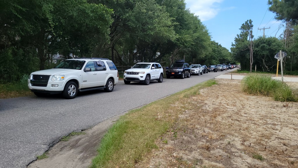
Among the nine residents, seven spoke about the traffic and the problems of congestion and speeding, as well as public urination and trespass by vacationers who exit their vehicles and use residents’ property to relieve themselves. Four of the seven asked for the orange, water-filled barricades that were placed at street intersections in the dunes from Memorial Day weekend through June 25-26 to be restored, saying they helped to reduce cut-through traffic flow.

Among them, Jerrica Rea, who lives on Sea Oats Trail between Hickory Trail and Hillcrest Drive, complained about the bathroom breaks she and her family witness and also said cut-through vacationers use her driveway and her trash cans and even park in her parking space.

Ms. Rea’s neighbor, Susan Adams, said public urination has become old news. Besides supporting the barricades, she called attention to speeding by cut-through drivers and to the road wear-and-tear that their vehicles cause.

Rick Haley of the north end of Wax Myrtle Trail said he had to endure “peeing” and the disposal of “dirty diapers” on his yard every summer weekend since 2017—until the “Local Traffic Only” barricades were employed.

Mr. Haley said that the barricades “helped us 100 percent.”  

Mayor Morey seemed surprised by this declaration.

“That’s the first time I’ve heard that,” she told him, apparently referring to his resounding support of the barricades because certainly residents have informed Town officials previously about their effectiveness.

Mayor Morey explained that the road barricades were removed because of “conflicts” that arose between “drivers and residents, residents and residents, and drivers and drivers.” People had heated exchanges in the streets, and too many cut-through drivers were ignoring the barricades.

Robert Green Sr. of Hillcrest Drive also said, “The barricades were working,” and vigorously pressed the Mayor for an accounting of the Town’s decision to remove them.

Ultimately, the Mayor acknowledged “it was a subjective decision,” not based on any incident data, and said the Town could “deploy the barricades again.”

She did not explain the logic of using the barricades when there are fewer vehicles on the cut-through route, and, thus, less need for them. Her chief concern seems to be to minimize the risk of angry confrontations occurring on the streets.

Tommy Karole, former chairperson of the citizens’ committee that studied cut-through traffic and recommended installation of a gate on South Dogwood Trail, renewed the committee’s proposal, explaining that tiny transponders attached to locals’ license plates or windshields would be used to open the gate.

Conditions as they are now are “unsafe,” Mr. Karole said, “and it’s obscene that our Council allows” them to exist. As he has in the past, Mr. Karole warned of the delay that backed-up traffic poses to emergency medical service vehicles and other first responders.

Mr. Karole, who lives on East Dogwood Trail near the North-South-East Dogwood trails intersection, also complained of vehicles speeding on East Dogwood Trail across the Dick White Bridge as cut-through drivers accelerate once they turn right (often without stopping) onto the road from South Dogwood Trail. Speeding also occurs in the other direction, but less flagrantly.

Wendy Hawkins of South Dogwood Trail responded favorably to Mr. Karole’s gate proposal, expanding upon it by suggesting that another means besides a transponder, such as a keycode, could be used to allow access to “people who legally need to get through.” Smart-phone technology opens up other possibilities.

Determining who would require access in addition to local residents—such as non-resident property owners, guests of homeowners and of the Duck Woods Country Club, renters, and essential servicepeople—and how to enable that access are just two of the issues associated with installing a gate.

Before Town officials get to assessing the logistical, technological, and physical requirements of a gate, however, they must resolve the hesitancy they feel about the legal position the Town would be in if it were to close South Dogwood Trail to cut-through drivers. There is no North Carolina law that prevents it from doing so. The Beacon will explore the legal picture in a future blog.

Ms. Hawkins spoke forcefully about the speeding and reckless driving on South Dogwood Trail that pose a danger to people walking on the sidewalk. She described vehicles coming so close to the curbs that their hubcaps scrape them.

A car “could jump the sidewalk,” she said, if drivers persist in rivaling on-coming traffic for passage, instead of yielding. It’s an eye-of-the-needle situation when two wide vehicles meet.   

Ms. Hawkins said she had two of the Town’s “Please be respectful” signs in her yard—and she even held one up for passing drivers to see—but she took them down “because they weren’t doing any good.”

“I’m very angry,” she said. “It’s horrible.”

Ms. Hawkins’s suggestion of installing a “Local Traffic Only” barricade on South Dogwood Trail was quickly dismissed as unworkable by Chief Kole and other Town officials.

WHICH CAME FIRST: CHICKENS OR EGGS, ANYONE?

Among other topics discussed at the chat, a Chicahauk homeowner asked about potential construction on Gravey Pond Lane; an Ocean Boulevard homeowner inquired about the Town extending its complimentary trash and recycling receptacle rollback service on Ocean Boulevard beyond the Duck Road split; and Jerrica Rea outed herself as “the chicken lady.”

Ms. Rea has campaigned on the social media site, Next Door, for the Town to allow residents to raise chickens, as the towns of Kitty Hawk and Kill Devil Hills do.

The “keeping and having of livestock and fowl” in town is prohibited by Southern Shores Town Code sec. 4-24. The Code defines “fowl” as “edible birds commonly found on farms, such as chickens, turkeys, ducks, guinea fowl and geese.” (Sec. 4-21)

Ms. Rea revealed yesterday that she had spoken with Mr. Ogburn about the possibility of raising chickens at her home and that she had hired an attorney to assist her. Because of an issue with property covenants, Mr. Ogburn had not yet advised Ms. Rea about the process for repealing a Town Code ordinance.    

Mayor Morey indicated that she has heard strong opposition to chickens (or more precisely, hens) being allowed in Southern Shores. She suggested that the topic would be an appropriate one for discussion in one of the public workshops that will be held after the Town initiates its update of its Coastal Area Management Act (CAMA) Land Use Plan. The first such workshop could be held as early as September.

(The Beacon will inform readers about the Land Use Plan update after a consultant is hired to run the process, which is established by State law and regulations. The Town issued a Request for Proposal on July 1 for a “qualified firm” to update the currently adopted Land Use plan, which, although certified by the N.C. Coastal Resources Commission in 2012, was submitted to the State in 2008 and based, in part, on a public workshop and citizens’ survey conducted in 2005. Proposals for the update must be submitted to the Town by 5 p.m. on July 22.)

‘AFFORDABLE HOUSING’: A CHALLENGING ZTA FOR THE PLANNING BOARD

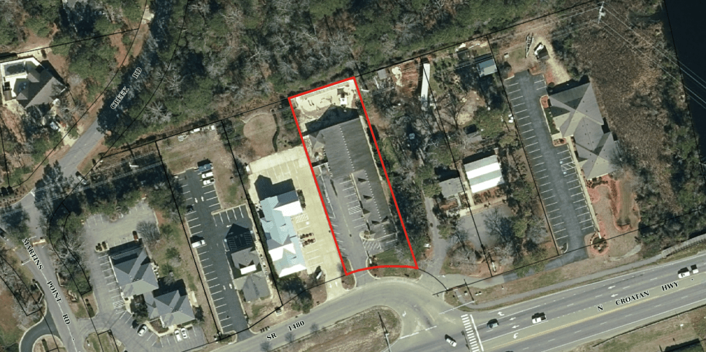
The Town Planning Board will consider at its meeting next Monday a Zoning Text Amendment (ZTA) submitted by the owner of the Pledger Palace day care center to allow a residential structure she is calling a “shared space-occupancy dwelling” to be built in the C general commercial district of Southern Shores.

A document submitted by Patricia Pledger, president of Pledger Palace Child Development and Educational Center, Inc., with ZTA 22-08 indicates she envisions a so-called SSO as “an affordable housing solution” for international students coming to the Outer Banks through the J-1 summer work visa program.

Ms. Pledger is proposing converting her childcare facility at 6325 N. Croatan Hwy. in the Martin’s Point area into communal housing for at least 95 “non-transient” J-1 students.

According to Deputy Town Manager and Planning Director Wes Haskett, the Pledger Palace property is located in Southern Shores’ extraterritorial jurisdiction (ETJ), so it is “subject to the Town’s development requirements.”

John Finelli is the ETJ representative on the Planning Board.

The Pledger Palace is currently operating as a summer camp for children, according to Ms. Pledger’s letter.

The Board will meet Monday in the Pitts Center at 5 p.m. It also will take up a housekeeping ZTA submitted by the Town itself to ensure that the Town Code is consistent with N.C. statute.

See the Board’s agenda at https://www.southernshores-nc.gov/wp-content/uploads/2022/07/7-18-22-PB-Meeting-Agenda.pdf.

ZTA 22-08 proposes to amend the permitted uses section of Town Code sec. 36-207, which regulates the commercial district, to add shared space-occupancy dwellings, as well as to add a definition of an SSO to the Zoning Ordinance’s definitions section 36-57.

The Pledger Palace is being represented by attorney Casey C. Varnell of Sharp, Graham, Baker & Varnell in Kitty Hawk.  

The crux of the proposed zoning change is the definition of an SSO, which is described in ZTA 22-08, in significant part, as a “private structure” with “shared spaces . . . offered for rent for the purpose of providing affordable sleeping accommodations” to “persons who do not meet the definition of family.”

Each “shared space” may “accommodate up to 10 bunk units (maximum of 20 occupants).” It is further described as existing within “the confines of four walls, and separate and apart from any other shared space within the structure.”

ZTA 22-08 further specifies that residents of the SSO “shall share a kitchen facility and common living area with all other residents and shall share a bathroom facility with one or more other residents.” The owner of the SSO cannot use it as a primary residence, according to the ZTA.

The proposed definition concludes with this disclaimer: “SSO does not include dormitory and residence halls, single-family dwellings, multi-family dwellings, motels, or vacation cottages.”

Although the terms “dormitory” and “residence halls” are not defined in the Town’s Zoning Ordinance, both are prohibited in all zoning districts in Southern Shores by Code sec. 36-209(9).

ZTA 22-08 also would amend Town Code sec. 36-207(b), the permitted uses section, with details about the parking, bathroom facilities (separate for males and females), permitting, and other matters pertinent to SSOs.

See ZTA 22-08 at https://www.southernshores-nc.gov/wp-content/uploads/2022/07/7-12-22-ZTA-22-08-Shared-Space-Occupancy-Dwellings.pdf.

Although Ms. Pledger has submitted ZTA 22-08 in order to convert her childcare facility into “affordable housing” for J-1 students, the Town’s enactment of a new permitted use in the commercial district such as she is proposing would apply throughout the district. What she has submitted is not a building project peculiar to her property.

We think the Planning Board is going to find both the concept of a shared-space occupancy dwelling and the language defining it challenging, even though members may consider the purpose behind ZTA 22-08 laudable.  

Ann G. Sjoerdsma, 7/14/22

7/6/22: TOWN COUNCIL, TOWN MANAGER NIX USE OF BARRICADES ON CUT-THROUGH ROUTE, OFFER NO OTHER RELIEF FROM CONGESTION. CHIEF KOLE OUTLINES POLICE ACTIONS OVER JULY 4TH WEEKEND.  

The Town Council and Town Manager Cliff Ogburn had nothing new to say about the cut-through traffic at last evening’s Council meeting except that, as bad as it was last Saturday, according to Mr. Ogburn, it “would have been worse with the [‘Local Traffic Only’] barricades.”

The more barricades that the Town puts up, said Mayor Elizabeth Morey, “the more potential [there is] for public-safety incidents.”  

We wonder how the “potential” for public-safety “incidents” compares with the “potential” for public-safety “incidents” caused by the relentless, all-day stream of traffic clogging the roads.  

Unfortunately, one cannot prove potential; nor can one prove that road conditions would have been worse had there been barricades. We don’t have a control group of roads to test Mr. Ogburn’s hypothesis. We only have conjecture.  

Although traffic was very heavy last Sunday, too, the tepid discussion that Town Council members had focused on Saturday. At its conclusion, both Council and Manager confirmed that the barricades would not be used in the foreseeable future. They see them as a source of tension and strife between residents and vacationers driving through town on residential streets.

Town Council member Mark Batenic did not attend yesterday’s meeting. He also was absent for the June 21 workshop meeting.

Mayor Pro Tem Matt Neal aptly described conditions Saturday on the South Dogwood Trail cut-through route as “horrendous” and referred to the 4:30 p.m. to 5 p.m. vehicle backup in the dunes as a “parking lot.” He expressed sympathy for residents, but offered no suggestions for traffic mitigation, saying that the volume of traffic through town—on N.C. Hwy. 12 and the cut-through route—is simply too great.

Town Councilwoman Paula Sherlock mentioned emails sent to the Town Council by residents that attest to a strong difference of opinion about the barricades. We wish she had elaborated on this point. Our belief is—and our mail indicates—that residents strongly objected to the closing of Hickory Trail, but not to the barricades on other streets, which inconvenience residents only slightly because they can drive around them.

It was when Hickory Trail was closed that traffic backed up on South Dogwood Trail to the cemetery. Last Saturday, with Hickory Trail open and no other barricades in place, traffic backed up on South Dogwood Trail past the Duck Woods Country Club to the Kitty Hawk Elementary School, Mr. Ogburn said.

The Town Council and Town Manager attributed this backup to the fact that it was a holiday weekend. What will be their reason when it happens this Saturday?

Mr. Neal said that, based on previous traffic data, the weekend traffic flow through Southern Shores will continue to be heavy through July and start to taper off in August.

The Town Manager reported a traffic count of 5069 vehicles on South Dogwood Trail last Saturday, which he compared favorably to a count of 4581 vehicles on the street on July 3, 2021, when the “no left turn” was in effect on U.S. Hwy. 158.

We do not believe it is possible to evaluate the meaning of last year’s count, without knowing what the level of police enforcement of the left-turn prohibition was. A better comparison might have been with Sat., July 4, 2020, when, according to Town traffic data obtained by The Beacon last year, 3249 vehicles traveled on South Dogwood Trail—nearly 2000 fewer than traveled on it last Saturday.

The pandemic 2020 summer season was a boom season for the Outer Banks. We suspect, but cannot say with certainty, that police monitored the illegal left-turning traffic on the July 4th weekend that year. But there also was no 7-Eleven parking lot at the 158-South Dogwood Trail intersection offering vacationers a left-turn work-around.

Mr. Ogburn previously informed The Beacon that the U.S. 158-South Dogwood Trail intersection was lightly monitored in 2021 by Southern Shores police, who issued only 32 citations for its violation all summer. That is an average of 1.78 tickets issued per day that the turn prohibition was in effect.

The Town will continue to put a “strong effort” into “educating” vacationers that they are “better off” staying on U.S. Hwy. 158 and N.C. 12, than driving on the South Dogwood Trail cut-through route, Mr. Ogburn said. The N.C. Dept. of Transportation is assisting the Town by providing road signage that encourages vacationers to stay on the state roads.  

POLICE ACTIVITY LAST WEEKEND

In an effort to inform the Town Council and the public about what police were doing over the holiday weekend, Police Chief David Kole ran through the calls and incidents to which the police responded “above and beyond dealing with the traffic.” According to the Chief, they were as follows:

Sat., July 2:

  • Three traffic accidents, one on South Dogwood Trail, two on Duck Road
  • A larceny call
  • Two mutual aid requests, one from Currituck County, which was a “burglary in progress with shots fired” (apparently a resident thought he saw a burglar and fired a gun), and the other from Kitty Hawk
  • Request from Kitty Hawk Police Dept. for assistance with an “overdose” at McDonald’s; the Southern Shores officers “brought [the victim] back with Narcan,” Chief Kole said
  • 19 traffic stops
  • Two motorist assistance calls
  • One response to a water rescue
  • Two burglar alarms going off
  • Two “talk with an officer”
  • K9 training
  • One traffic hazard (a tree in the road was removed)

Sun., July 3:

  • An accident with injuries (a vehicle flipped over near Porpoise Run)
  • Two “domestics in progress”
  • Two calls about a protest on Ocean Boulevard (no violations cited)
  • One “underage drinking on the beach”
  • A “mutual aid” from Kitty Hawk for a foot chase; the K9 “was deployed”
  • One animal call
  • One suspicious vehicle
  • One “talk with an officer”

Chief Kole did not detail any of these calls or incidents beyond what we have described above. Although he mentioned the number of traffic stops that occurred on Saturday, he did not do the same with Sunday.

The Chief also reported on service calls “not related to the traffic” that the police handled on Fri., July 1, and Mon., July 4. Monday’s calls featured an eclectic assortment that included:

  • One domestic assault
  • One verbal assault
  • One noise disturbance
  • K9 training
  • A grass fire near 102 Ocean Blvd. (assist the Fire Dept.)

And one whose resolution elicited an undercurrent of laughter from people attending the meeting:

  • Family that was panhandling at the Marketplace

“We moved them to Kitty Hawk,” Chief Kole reported.

MAYOR’S CHAT

Mayor Morey reminded all members of the public that she will host a Mayor’s Chat next Wed., July 13, at 4 p.m. in the Pitts Center.

Ann G. Sjoerdsma, 7/6/22

7/5/22: TOWN COUNCIL MEETS AT 5:30 P.M. TODAY.

Town Manager Cliff Ogburn’s updates on seasonal traffic and on street improvements scheduled this year headline a Town Council meeting today at 5:30 p.m. that is light on business–a nice change of pace.

As usual, the Council’s regular first-Tuesday meeting will be held in the Pitts Center and will have two public-comment periods for people who sign up to speak immediately before the meeting.

The Town’s Fire Chief, Police Chief, and Deputy Town Manager/Planning Director also will be giving their reports on the month of June.

You may access the meeting agenda here: https://mccmeetings.blob.core.usgovcloudapi.net/soshoresnc-pubu/MEET-Agenda-dac3b7315b464618a089e89ed005639e.pdf

You may live-stream the meeting at https://www.youtube.com/user/TownofSouthernShores.

We encourage all residents to attend the meeting or to tune in.

We also remind you that Mayor Elizabeth Morey will be holding a Mayor’s Chat in the Pitts Center on Wed., July 13, at 4 p.m.

THE BEACON, 7/5/22

6/30/22: ALL TOWN RESIDENTIAL STREETS WILL BE OPEN THIS WEEKEND; BARRICADES, SIGNS WILL BE REMOVED.

A sign at Hickory Trail near its intersection with Hillcrest Drive warns June 11 of the popular cut-through road’s closure. Numerous drivers, including locals, ignored the sign.

All residential streets in Southern Shores that have been blocked with “Local Traffic Only” barricades in anticipation of thousands of northbound vehicles driving through neighborhoods will be open this weekend, the Town announced in its biweekly newsletter today.

“With this weekend’s traffic expected to be the peak of the summer,” the announcement says, “we have determined that it is best to remove barricades on all Town streets. This will provide as many outlets as possible and expedite traffic throughout Southern Shores.”

The Town first placed orange, water-filled barricades and regulatory “Road Closed Local Traffic Only” signs at intersections along the South Dogwood Trail-East Dogwood Trail-Hickory Trail cut-through route, on Juniper Trail, and on Ocean Boulevard over the Memorial Day weekend. The barricades blocked the northbound lanes at multiple intersections, including those on East Dogwood Trail and Hickory Trail with Hillcrest Drive, Sea Oats Trail, and Wax Myrtle Trail. The barricades were placed at the same 10 locations over the June 4-5 weekend.

While residential roads experienced heavy traffic on both of those weekends, conditions on the cut-through route became “chaotic,” Town Manager Cliff Ogburn told the Town Council at a recent meeting, when the Town experimented with closing Hickory Trail to all traffic at the Hickory Trail-East Dogwood Trail. This closure elicited much “anger and resentment toward the town,” Mr. Ogburn said, and “police had a lot of calls from upset residents.” (See The Beacon, 6/23/22, for background.)

The closure of Hickory Trail is referenced in the Town’s announcement today, which further reads:

“When addressing traffic issues in one part of our community, the Town did not intend to create new or worse problems in other parts of town. In some cases, efforts to ease cut-through traffic have created conditions worse than those addressed. The blocking of Hickory Trail at East Dogwood is an example of the effect being worse than the cause. Traffic being backed up to the cemetery on South Dogwood is not an outcome we can allow. Once East Dogwood Trail and Hickory Trail were opened for traffic, we still experienced lengthy backups on South Dogwood. The barricades at several intersections that are intended to discourage non-local traffic from cutting through contributed to the back-ups. We are experiencing different results from these barricades this year than last.”

There is no question that northbound motorists brazenly ignored the barricades, driving around them as they traversed the Southern Shores woods and dunes to reconnect with Hwy. 12 (Duck Road) at its intersections with Hickory Trail, Hillcrest Drive, Eleventh Avenue, and Sea Oats Trail. The same was true on Ocean Boulevard. Vacationers have learned that the “Local Traffic Only” signs are not backed up by law enforcement.

While we knew that our suggestion recently to have police cite motorists for violations at the end of the roads they illegally enter would be labor-intensive and would not be met with favor by Police Chief David Kole, we did not expect the Town to pull the plug altogether on traffic mitigation on the roads themselves. We are very disappointed. (See The Beacon, 6/26/22)

We contacted Tommy Karole, the chairperson of the former Southern Shores Citizens’ Committee to Study Cut-Through Traffic, for his comment on the Town’s action. The cut-through traffic committee recommended a gating system to relieve weekend congestion.

“If the Town Council had taken the time to listen to what the cut-through traffic committee found in its research,” Mr. Karole told The Beacon, “they wouldn’t have wasted the time and money over the last two years that they have.” Mr. Karole further said that he predicted the conditions that have occurred on weekends since Memorial Day.

According to The Beacon’s reporting, the Town Council did not take up the cut-through traffic in a public meeting after Sept. 7, 2021 until the Town held a public-information forum during which Mayor Elizabeth Morey’s traffic mitigation plan for the summer was announced.

Today’s Town newsletter announcement concludes with the statement that “We will continue to alert visitors that they will experience less congestion if they remain on U.S. 158 and N.C. 12.” It refers readers to https://www.youtube.com/watch?v=OpQ3-tKSa3Y for the “latest message.” (One slogan, delivered on the videotape by the voice-over of a young child: “Don’t cut through, stay on N.C. one-two.”)

TOWN COUNCIL MEETS NEXT TUESDAY, JULY 5

The Town Council will meet for its regular monthly meeting next Tuesday, at 5:30 p.m., in the Pitts Center. The meeting agenda, which was posted on the Town website today, shows that the Town Manager will give an update on traffic and on the street improvement project during his report. You may access the agenda here: https://southernshores-nc.municodemeetings.com.

MAYOR’S CHAT JULY 13           

Mayor Morey will hold an informal Mayor’s Chat on Wed., July 13, at 4 p.m., in the Pitts Center.

Ann G. Sjoerdsma, 6/30/22

6/27/22: WAZE AND GOOGLE ARE SHOWING WEEKEND ROAD CLOSURES, AS TOWN MANAGER REQUESTED, EDITOR CONFIRMS.

MrNicGuy has confirmed that Town Manager Cliff Ogburn’s road closures on summer weekends have appeared on Waze and Google apps, as the Town Manager has requested. The “lapse” that we referred to in blog and Facebook comments originated with MrNicGuy, not the Town.

The Town is a Waze for Cities partner, so it has the ability to close roads in the Waze app at will, and those closures go over to Google maps.

MrNicGuy is in Virginia. He said he is “having discussions with N.C. Waze editors on how we can help further.”

So . . . the Town Manager’s closure requests have been and will continue to be honored. We apologize for causing any undue ruckus by reporting on MrNicGuy’s email and not contacting the Town Manager. Haste makes waste. But now we know at least one Waze map editor is reading The Beacon traffic reports.

Ann G. Sjoerdsma, 6/27/22

6/27/22: WAZE MAP EDITOR ASKS THE BEACON FOR LOCATIONS OF ‘LOCAL TRAFFIC ONLY’ SIGNS IN TOWN SO APP DOES NOT GIVE VACATIONERS THE CUT-THROUGH ROUTE.

A volunteer map editor for the Waze app contacted The Beacon by email this morning to ask where the “Local Traffic Only” signs are posted in Southern Shores on summer weekends so Waze does not direct motorists to take the regulated side streets.

The editor, whose alias is “MrNicGuy,” said he had been “following the various stories of the traffic cut-thru problem at Southern Shores” and is aware that “people blame navigation apps like Waze for [their] cut-thru problems.”

Sometimes, however, he noted, motorists know about a cut-through route and simply choose to take it, regardless of what the navigation app suggests.

If a municipality “has posted ‘Local Traffic Only’ signs,” as Southern Shores has, MrNicGuy said, Waze “can make sure our app does not add to the traffic headache by almost never providing a route through the side streets.”

At MrNicGuy’s request, we gave him the locations of the “Local Traffic Only” signs. He said he also would be in touch with Town Manager Cliff Ogburn.

MOBILE SIGN ON SOUTH DOGWOOD TRAIL INEFFECTIVE: We also would like to point out that the message we observed yesterday on the mobile road sign near the Kitty Hawk Elementary School was not an effective deterrent to cut-through traffic. In somewhat confusing phrasing, the sign advised motorists that if they continued on South Dogwood Trail, they would encounter a delay, and they would be well-advised to stay on U.S. Hwy. 158. A far more effective message to cut-through drivers would be: “Roads Closed Ahead, Local Traffic Only.”

Ann G. Sjoerdsma, 6/27/22

6/26/22: POLICE SHOULD ENFORCE THE ‘LOCAL TRAFFIC ONLY’ SIGNS AT THE END OF ROADS, NOT THE BEGINNING, CITING DRIVERS BACKED UP AT DUCK ROAD INTERSECTIONS.

Northbound traffic backed up on Sea Oats Trail from its intersection with Duck Road. (Photo courtesy of a Southern Shores homeowner.)

Why doesn’t the Town enforce the “Road Closed/Local Traffic Only” signs that are beside the orange, water-filled barricades that block northbound traffic in every intersection of the Hickory Trail/Hillcrest Drive/Sea Oats Trail/Wax Myrtle Trail summer weekend cut-through route?

This is one of the recurring questions that angry residents have: What is the point of putting up signs and barricades and then not enforcing the “Local Traffic Only” regulation?  

We have heard from Town Manager Cliff Ogburn numerous times as to why no enforcement occurs. He stated the reason again last Tuesday at the Town Council’s mid-month workshop meeting. (See The Beacon, 6/24/22 for a report.)

“The police cannot,” Mr. Ogburn said, “ . . . pull someone over or stop someone from going around those ‘local traffic only’ signs.

“They can’t pull someone over for suspicion,” he continued, “of not being a resident or having a right to that street.”

In addressing his officers’ lack of enforcement at the same meeting, Police Chief David Kole said about the barricaded roads: “They’re still public streets, and people have a right to traverse them.”  

It would seem the Chief is not acquainted with N.C. General Statutes sec. 160A-296, which gives municipalities general authority and control over public streets, including the power to close any street temporarily and to “regulate the use” of public streets. (NCGS sec. 160A-296(a)(4) and (5).)

We revisit this area of contentious dispute again because yesterday we learned from Southern Shores homeowners on the scene that a woman walking her dog decided to block a stream of afternoon cut-through vacationers from turning left on to Hickory Trail by standing in the road. She turned herself into a mobile barricade.

While we appreciate this dog walker’s frustration, we do not recommend such protest or citizen enforcement. It is too dangerous.

We also agree with Mr. Ogburn that the police cannot pull motorists over on “suspicion” alone.

It is undeniable, however, that the Town of Southern Shores has legal authority to close and regulate use of its streets. Further, the “Road Closed/Local Traffic Only” signs are expressly sanctioned by the Federal Highway Admin. in its “Manual on Uniform Traffic Control Devices.” When violated, these “Local Traffic Only” signs can be enforced by local police with a citation, just like any other regulatory street sign.

The issue really is, when can police cite a motorist on the cut-through route with violating a sign that clearly tells him/her to take a different route unless he/she has no other option to reach his/her destination within the restricted area? In other words, when does suspicion become fact?

We submit that any northbound motorist who is in a backup of vehicles stopped at the intersections of Duck Road (N.C. Hwy. 12) with Sea Oats Trail, Eleventh Avenue, Hillcrest Drive, or Hickory Trail has violated one or more “Local Traffic Only” signs to get there and can be cited by a police officer for a traffic infraction. (If a local is among them and has a justifiable reason for being at the intersection, he/she can be quickly identified.)

We don’t need police officers at the entrances to barricaded roads, sometimes responding to tourists whom Chief Kole described sympathetically Tuesday as “upset” and “ticked off,” we need them at the outlets of these roads, issuing citation after citation to cut-through motorists stuck in gridlock in front of our residences. There’s no need to pull any vehicle over.

If such regulatory enforcement were to occur, we guarantee that northbound vacationers’ behavior would change. Few people want to start a vacation by receiving a traffic ticket.

And if they’re “upset” and “ticked off,” the police should tell them to take it up with Duck or Currituck County. We’re just keeping our roads safe.

FORMULATING A TRAFFIC PLAN      

We have been working on formulating a different use of the barricades and “Local Traffic Only” signs along the cut-through route than what the Town Manager is currently doing.

Our plan is based on road closures, so it is a bit complex and would likely require the purchase of more barricades, an expense the Town Council has already approved. Until we have run our plan past some residents along the cut-through route, and received their support, however, we are not prepared to present it.

One aspect of it, however, we will promote now.

There is no reason for the section of Ocean Boulevard, from the Duck Road split to the Hickory Trail/Duck Road intersection, to be used as a “shortcut” around the congestion on Duck Road. Hickory Trail at Duck Road should be closed on summer weekends, as should Periwinkle Road at Duck Road.  

We support continuing to place a “Local Traffic Only” barricade on Ocean Boulevard (around 142 Ocean Blvd.) in the northbound lane and would advocate putting a “No Outlet” or “Detour” sign on Ocean Boulevard just before East Dogwood Trail, so anyone who has been foolish enough to jump off the thoroughfare on to Ocean Boulevard is directed to the East Dogwood Trail/Duck Road intersection.

These road closures and rerouting might cause some backups on Ocean Boulevard initially, but they should dissipate as word gets out that this shortcut is not a shortcut. If they don’t, then we’ll revise our thinking.

We wish everyone a pleasant Sunday.

Ann G. Sjoerdsma, 6/26/22

6/23/22: TO THE DEFENSE: MAYOR, POLICE CHIEF RESPOND TO COMPLAINTS FROM ‘UPSET’ RESIDENTS ABOUT CUT-THROUGH TRAFFIC, OFFER NO NEW IDEAS, CHANGES.

Traffic backs up on Hickory Trail from Duck Road east to Ocean Boulevard last Saturday around 4 p.m. (Photo courtesy of a Southern Shores homeowner)

Responding to complaints about cut-through traffic from angry and frustrated residents, Mayor Elizabeth Morey admitted publicly for the first time Tuesday that the Kitty Hawk Town Council “declined to support implementing” the no-left-turn at the U.S. Hwy 158-South Dogwood Trail intersection this summer, “so, therefore, we’re not doing it.”

Ms. Morey also brought up at the Town Council’s Tuesday morning workshop—half of which was devoted to evaluating the Town’s traffic mitigation plan so far—overtures she made to Duck officials for help with moving weekend traffic through that town. Both Police Chief David Kole and Town Manager Cliff Ogburn contributed to this critical discussion about traffic.

Councilmen Leo Holland and Mark Batenic did not attend the meeting.  

(The Beacon reported 5/13/22 on Kitty Hawk’s refusal to participate in the left-turn prohibition, which was in effect in 2020 and 2021 during the surging pandemic summers. For other background on the Town’s plan, see The Beacon, 4/27/22, 4/29/22, 5/10/22, and 5/15/22.)

In his presentation, Chief Kole first disputed complaints his department has received from residents on South Dogwood and Sea Oats trails about speeders on their streets.

“People’s perceptions are obviously sometimes misguided,” the Chief said, before citing average speeds on South Dogwood and Sea Oats that have been at or below the speed limit.

He also cited a vehicle count on South Dogwood Trail last Saturday that was nearly as high as the highest vehicle counts on that street last summer, when pandemic weariness and the no-left-turn were in effect. According to the Chief, 4200 vehicles traversed South Dogwood Trail on June 18, as compared with 4581 on July 4, 2021, and 4206 on July 11, 2021. (The 2021 dates were Sundays; perhaps he meant the Saturdays of these weekends.)

Sea Oats Trail apparently had 3,800 vehicles last Saturday, as residents there, the Chief said, were “getting slammed.

Town Manager Ogburn, who has been instrumental in trying to curtail cut-through traffic with the use of “local traffic only” barriers, characterized them as having had “less of a negative impact [last summer, for both residents and tourists] than they’re having now.”

Mr. Ogburn referred to residents’ “anger and resentment” toward the Town and to “conflict” and “tension” arising because of the orange, water-filled barriers, which themselves “are creating an issue.” (Both resident and non-resident drivers do like to move them and complain about them.)

Mr. Ogburn said, discouragingly, “I’m not sure they’re having the positive impact we would want.” He no longer believes, he added, that two of every 10 northbound vacationers are being deterred by them—a low threshold that he always thought made them worthwhile.

Chief Kole was blunter than the Town Manager about the barriers. They are “not working,” he told the three Council members.

“[Vacationers] are driving around the barricades,” he said, because “GPS is telling me to go” on a street that is either closed (as Hickory Trail was for two weekends) or closed to non-local traffic.  Once one motorist transgresses, others follow suit.

The July 4th weekend is “going to be a hoot,” the Chief said. “Trust me.”

MAYOR’S COMMENTS

The Mayor made no mention of Kitty Hawk’s refusal to back the left-turn prohibition, which the N.C. Dept. of Transportation required before it would permit a blockage, at the Town’s April 26 public-information meeting on summer traffic mitigation.

She didn’t bring it up at the Town Council’s May 3 meeting, either, when Mr. Ogburn discussed the traffic plan/campaign endorsed by the Mayor, which is heavy on road signage and other communication designed to keep motorists on U.S. 158 and N.C. 12.

But the Mayor is now on the defensive because of complaints from what Mr. Ogburn referred to as “upset residents”—many of whom are calling the police—and she spoke as openly at the Tuesday workshop as we have ever heard her speak about the Town’s efforts to mitigate cut-through traffic.

At the April 26 meeting, she stated simply that the no-left-turn would not be in effect. Period. No explanation. She left the Town Manager to respond to questions about why not. On Tuesday she elaborated upon the safety problems that arose last summer, with the 7-Eleven being used as a turnaround and people making U-turns in the middle of U.S. 158, and mentioned traffic accidents at the 158-South Dogwood Trail intersection, although she didn’t quote any statistics.

Ultimately, however, she seemed to lay any blame on Kitty Hawk.  

Also Tuesday the Mayor said she had reached out to “elected officials” in Duck, as she claimed Mayor Tom Bennett previously had, to ask them to reduce the number of pedestrians impeding traffic flow on Hwy. 12 during summer weekends.

These officials, she explained, “choose not to implement anything to mitigate the effect of pedestrians blocking the cars from moving through the Town of Duck in a faster, safe way.”

We wish the Mayor had told the public exactly what cooperation she sought because in explaining the officials’ decision, she mentioned pedestrians only at the “south end” of Duck.

Duck, she said, had a traffic study done of the south end, where the speed limit drops to 25 mph, and it concluded that “pedestrians aren’t the problem.”

We agree they’re not the problem at the south end; the speed limit is. We also guarantee that if you funneled all pedestrians on N.C. 12 in Duck from 13 crosswalks to three, the traffic would move faster. And if you put a police officer at each crosswalk, you would not have pedestrian stragglers holding up the traffic flow. It’s simple physics.

SPEEDING DISPUTE

In addressing speeding reports, Police Chief Kole told the Council that “We are continuously getting calls from certain people on South Dogwood that claim cars are going 50 mph, and at the same time it’s bumper-to-bumper traffic.”

The same, he said, is true on Sea Oats Trail: speeders, but bumper-to-bumper traffic.

We see no inconsistencies in these reports. Clearly, motorists can’t speed when the traffic is at a standstill, but they can, and they do, when the traffic opens up during non-peak hours on the weekends.

Average speeds obtained from radar don’t tell the tale. There is no way to know whether a northbound motorist travels at 50 mph at noon on a Saturday and a late-arriving motorist travels at just 15 mph or less at 4 p.m.

We were unable to view the speed data that the Police Chief displayed on overhead projection at Tuesday’s meeting because the videographer did not zoom in on them. Based on what Chief Kole said, we believe the data showed the weekly number of vehicles on these streets and the speed at which radar detected all of them.

Somehow Chief Kole was able to say that the average speed on South Dogwood Trail at the cemetery for one week when 8909 vehicles traveled there, was 25 mph. We urge the Chief to post his data on the Town website for all residents to see.

Chief Kole also offered the report of an officer who “conducted a lot of radar” on South Dogwood Trail last Saturday for proof that the average speed was 20 mph, and there were “no speeders,” but he did not say exactly when the officer patrolled the road. He wasn’t there for his entire 9 a.m. to 7 p.m. shift.

Apparently, when this officer, who was working overtime, according to Chief Kole, moved over to Ocean Boulevard at the Duck Road split, he and another officer were able to cite four or five motorists for speeding. This makes sense to us if the officers were near the SSCA parking lot just north the tower, where the speed limit drops to 25 mph, but the Chief did not say. He also didn’t give times for the citations.   

‘TRAFFIC IS TRAFFIC’

Mr. Ogburn said that the vehicle counts on N.C. 12—from Skyline Road in the south to 13th Avenue in the north—“look relatively consistent from weekend-to-weekend” since Memorial Day. But the volume of traffic on the “northern end of town” is “increasing a lot.”

Mayor Morey attested that while she was out walking last Saturday around 3:30 to 4 p.m., she saw only one car turning left (north) from East Dogwood Trail through the Duck Road traffic light during a green cycle. Not good.

She again called upon rental property managers to arrange more Friday-to-Friday and Sunday-to-Sunday rentals, even though managers tell her, she said, “We already do that.”

“Do more” is the Mayor’s response, she said.

We wonder if the Mayor has looked at the rental numbers for the different turnover days. It used to be very easy in the uncongested old days to pick up a rental brochure (now called a vacation planner) from Southern Shores Realty Co. and see immediately which homes rented from Friday-to-Friday and from Sunday-to-Sunday. It now takes a more painstaking effort to separate them out from among the hundreds cataloged, but they are numerous.  

The houses that SSR rents in Seacrest Village have long been Friday-to-Friday rentals. We counted 38 of them in SSR’s 2022 vacation planner.

We don’t think the turnover-day approach is a promising one.

Nor do we believe that advocating for the Mid-Currituck Bridge, which is on hold because of federal litigation, and filing an amicus curiae brief in the litigation between the NCDOT, the Federal Highway Admin., et al (there are multiple named appellee-defendants) and the non-profit anti-bridge groups represented by the Southern Environmental Law Center will speed up the construction process.

(The Town posted the amicus brief on its website today. Amicus curiae is Latin for “friend of the court.” The Town is not a party in the case, which is now in the U.S. Court of Appeals for the Fourth Circuit. The Town’s brief, which is joined by the Town of Duck, Currituck County, and other entities, essentially says we agree with the appellee-defendants’ argument, as did the lower U.S. District Court, which ruled in their favor on summary judgment. Summary judgment means that the NCDOT/FHA case is so strong that they are entitled to judgment as a matter of law, without having a trial.)

We respect attorneys who have a different opinion about filing this amicus brief, but we much prefer to consider practical, here-and-how traffic mitigation techniques. After the District Court’s ruling last December, the NCDOT announced a delay in the bridge project until early 2025. After that, pre-construction alone will take one year, according to the NCDOT.

Councilwoman Paula Sherlock, who has spearheaded the amicus brief effort, said Tuesday, “We are doing what we can do, but the traffic is the traffic.”

When asked by Mayor Morey whether he could think of any changes for improving the traffic, Chief Kole said, “I don’t have the answers. . . . But I can tell you that eventually we’re just going to have to say that we’ve done everything we can.”

We disagree with both of these conclusions. We’ve heard many other suggestions over the years—everything from speed humps to gates to police moving traffic along Hwy. 12, like a stadium event—but past Town Councils have ignored them.

Instead of discussing cut-through traffic at a 9 a.m. workshop with only 3/5 of the Town Council present, doesn’t it make more sense for the Town to hold a public forum to solicit ideas that it will actually consider? Or have we become so angry toward each other that we can’t even talk?

We all know the complaints are only going to multiply and get worse as the “after-school” crowd arrives and can legally turn left at South Dogwood Trail. Last summer we had the benefit of both staggered arrivals, because of remote school instruction, and the turn prohibition.

In explaining Kitty Hawk’s and Duck’s decisions to do their own thing, Mayor Morey reminded us that that’s democracy for you. Democracy is all we’re talking about here, too.

Mayor Morey will host a chat in the Pitts Center Wed., July 13, at 4 p.m.

Ann G. Sjoerdsma, 6/23/22

6/20/22: OPINION/ANALYSIS OF THE MIXED-USE ZONING CHANGE: A DISCONNECT, A COUNCIL OF TWO, AND A MISSED OPPORTUNITY.

The area outlined in red above is an undeveloped 7.9-acre commercial property tract in Southern Shores, part of which fronts on N. Virginia Dare Trail. (Courtesy of Dare County gis)

The Town Council recently unanimously approved a new mixed residential-commercial use of town property zoned commercial. Allowing “mixed-use” developments in Southern Shores, said Planning Board Chairperson Andy Ward, who spoke at the Council’s public hearing June 7 about the zoning text amendment that effected the change, “is a big leap for the town.”

Certainly, the Planning Board, which spent hours during the past few months thinking and talking about what was in the best interests of the town, thought so. The Town Council did not say much more publicly about the mixed-use concept than that members support it.   

We said two weeks ago that we would explore this zoning change, which has the potential to land condos next door to, or on top of, retail shops, and the “issues and problems that arise” for us because of the decision-making process that led to it.

We have reviewed the videotape of the Town Council’s public hearing several times since June 7, as well as watched Planning Board meeting tapes, and thought more about what we heard and what we know and have concluded that:

  1. A disconnect exists between the Planning Board and the Town Council, which makes us wonder how well they cooperate with, respect, and complement each other.
  2. Mayor Elizabeth Morey and Mayor Pro Tem Matt Neal, who were busy “behind the scenes,” determined the critical content of the mixed-use amendment to the Town zoning ordinance, and the other three Council members, whose comments June 7 reflected a lack of familiarity with that ordinance and confusion about what they were doing, just went along.
  3. With both the Planning Board and the Town Council focused on maximum allowable lot coverage for the new conditional use, both missed an opportunity to consider requiring “affordable” housing—what Dare County calls “essential and workforce housing”—  with the mixed-use change in what is known as “inclusionary zoning.” At the very least, the Town Council should have publicly discussed the potential for mixed use in Southern Shores beyond what Ginguite LLC, the commercial property owner that sought the zoning change, wants to do.  

We would like to stress to the Council members who were not included in the Mayor’s discussions with Ginguite and others before they voted June 7 on whether to approve its mixed-use ZTA that they have the option of motioning to table consideration of a ZTA.

Council members can (and should) take the time they need to understand what they are voting upon before they cast their votes. They’re making law!

FACTUAL BACKDROP

To authorize mixed use, the Town Council adopted at its June meeting a patchwork version of a ZTA that originated in February with Ginguite, a SAGA investor group that owns a marshy 5.2-acre commercial property at 6195 N. Croatan Hwy. (See The Beacon, 5/26/22, for background. We regret that we were on hiatus and did not track versions of this ZTA in the Planning Board.)

Ginguite purchased its property, which is adjacent to the Southern Shores Landing on U.S. Hwy. 158, in June 2014 with the expectation of developing it commercially, not residentially, according to SAGA Realty & Construction Co. Partner and CEO Sumit Gupta, who has been Ginguite’s principal representative. It had the option to do either.

Town Code section 36-207, which regulates the town’s C general commercial district, permits single-family, two-family (duplexes), and multifamily dwellings to be built in this district, per the standards of the high-density RS-8 multifamily residential district (section 36-203).

Sec. 36-207 also permits commercial “group” developments, with offices, retail stores, service establishments, etc., to be built. Until the Council approved mixed use two weeks ago, however, 36-207 it did not allow residential housing to be built with a commercial development on the same site.

According to Mr. Gupta, he met with Planning Director Wes Haskett earlier this year about developing the Ginguite tract, and the “consensus” that emerged from meetings he had with Mr. Haskett and other “town officials,” whom he did not identify, “was that the idea of bringing multifamily [dwellings] into group development was a good idea.”

For Ginguite to be able to combine residential and commercial uses on its tract, which has more than an acre of marshland and water and fronts on Ginguite Creek, it clearly needed sec. 36-207 to be amended.

The first ZTA (ZTA 22-02) that Ginguite submitted was skimpy. It proposed to add “group development of commercial and residential buildings” as a conditional use in the commercial district and specified only two conditions—one concerning the minimum building size, the other about connections between buildings—that a property owner would have to meet before being granted a special use permit.  

The applicant assumed that pre-existing requirements imposed by sec. 36-207 on commercial property developments would carry over to the mixed use. The Planning Board, which was very concerned about the relative percentage of residential and commercial uses in a mixed-use development and about maximum allowable lot coverage, did not agree.

After a lengthy Q & A with Mr. Gupta, the Board voted to deny recommending ZTA 22-02, advising him that Ginguite could withdraw ZTA 22-02 and submit a new ZTA with some of the items they had discussed. Subsequently, Ginguite submitted the more detailed ZTA 22-06.

In the meanwhile, the Town Council enacted a maximum density requirement of eight dwellings per acre for residential development in the commercial district (ZTA 22-04). This is the same density requirement that applies to dwellings in the town’s RS-8 multifamily residential district. (Most of us live in the RS-1 single-family dwelling district.)  

The Planning Board voted at its May 16 meeting to deny recommending Ginguite’s ZTA 22-06 because of a disagreement over lot coverage, and, in a highly unusual move, passed along to the Town Council its own version of ZTA 22-06 with its recommended requirements. The Board’s recommendations were not in a separate ZTA, but the Town Council treated them essentially as if they were.  

It is unclear to us how often Mr. Gupta met with Town staff and “Town officials” privately during the past few months, but we do know that Mayor Morey, Mayor Pro Tem Matt Neal, and Town Manager Cliff Ogburn met with Mr. Gupta on the morning of the Council’s June 7 public hearing on ZTA 22-06 because the Mayor told us so.

After the Council approved the mixed-use zoning change in a manner most favorable to Ginguite, the Mayor said that this ZTA effort consumed “a lot of thoughtful discussions” and “required some work,” and she thanked the staff, the Planning Board, and Town Council members for their contributions. She did not mention the Town Attorney.

We believe that in seeking to accommodate Ginguite, the Mayor took her eye off of the potential for mixed-use developments in the Town as a whole. We also believe that on June 7, she presented a “done deal” that discouraged Town Council members not privy to these “thoughtful discussions” from exercising an independent judgment.

ZTA 22-06: SITE SPECIFICITY . . .

To our knowledge, no Town representative brought up the possibility of enacting inclusionary zoning with the zoning change, presumably because Ginguite did not seek it.

But ZTA 22-06 is not site-specific. It applies to the Town at large. We see no reason why the Planning Board could not have recommended against Ginguite’s ZTA 22-02 and prepared its own ZTA on mixed-use development, giving more than just lip service to affordable housing.  

Mr. Gupta has pointedly said in public that any residential dwellings on Ginguite’s property will not be “workforce” housing; they will be “luxury” housing. Is this good planning policy for the Town’s future?

Inclusionary zoning is a term that refers to a host of different policies designed to set aside affordable housing in new developments (sometimes a percentage of “below-market” units). It is one of the tools by which municipalities nationwide are addressing the shortage of workforce housing. We wish the decision-makers in Southern Shores had considered it.

The point about site-specificity caused two Town Councilmen some difficulty during the Council’s deliberations on ZTA 22-06. One repeatedly asked if the ZTA applies to all commercial properties, or only to the Ginguite’s. Another asked whether what the Council was thinking about approving would allow the applicant “to do what he wants to do,” to get what he’s “asking for.”

It is discouraging to hear such confusion and wrongheadedness from Town government officials in deliberating an important town-wide zoning change.

Mr. Gupta told the Council that although a site plan for Ginguite’s property has not been prepared, a “design” has been circulated that envisions a “charming village” of luxury condominiums—with a walkway along Ginguite Creek, where boats could be launched—with small commercial buildings.  

We question the appropriateness of circulating that design. It should have had no bearing on the Town Council’s deliberations.

Inasmuch as that design was viewed by Town employees and representatives, in their public capacity, however, we believe it should have been included in the hearing materials provided.

Mr. Gupta assured the Council that Ginguite’s “intention” is not to enhance the value of the property with the mixed-use development potential and then sell it. Ginguite’s intention is not relevant to the Council’s deliberations, either.

We have learned on Dare County GIS that the Ginguite property was zoned residential when Boddie-Noell Enterprises, Inc., which includes the Kitty Hawk Land Co., sold it for $1 million in 2003 to the Northern Outer Banks Associates LLC. We do not know whether it was zoned then for RS-8 multifamily dwellings or for RS-1 single-family dwellings.

According to online data, the Northern Outer Banks Associates LLC incorporated in 2003 and dissolved in 2016. Its principal address and agent were in New Bern.

Ginguite LLC bought the property in 2014 from the Wells Fargo Bank—in default?—for $535,000. By then, the 5.2-acre tract had been zoned commercial. Unfortunately, we do not have time to research how that happened, but it does seem like Ginguite LLC got a bonanza.

. . . AND MAXIMUM LOT COVERAGE

The maximum allowable lot coverage of the new mixed-use group development conditional use in the commercial district was the major sticking point between Ginguite and the Planning Board and the Planning Board and the Town Council.

The requirements for the mixed-residential and commercial conditional use now appear in the Town Code as Section 36-207(c)(11), which sets forth the minimum building size, setbacks, lot coverage, and other conditions that must be met for a property owner to obtain a mixed-use special permit. The majority of these conditions are standards already in the Code sections for the commercial district and the RS-8 multifamily residential district.

The Council adopted some of the recommendations made by the Planning Board, but only one of them is not already in the Code. It rejected the Board’s recommendation about buildable lot coverage, which the five-member volunteer Board spent months “deliberately” considering, according to Mr. Ward.  

The maximum lot coverage permitted currently in the Town’s RS-8 multifamily residential district is 40 percent of the net parcel area; the maximum lot coverage in the commercial district is 60 percent of the total parcel area, although that can be increased to 67 percent if the developer uses a sufficient amount of permeable pavement.

The Planning Board arrived at what Mr. Ward called “a pretty good average of 50 percent” lot coverage for the mixed-use conditional use by “blending” the maximums allowed in the RS-8 district and the commercial district.

Mayor Morey and Mayor Pro Tem Neal disagreed with the Board’s 50 percent, which the Board also decided could be extended to 55 percent with permeable pavers. They endorsed the 60 to 67 percent maximum lot coverage permissible in the commercial district.

The Planning Board also wanted to calculate all mixed-use lot coverage according to the “net” parcel area, the standard used in the RS-8 residential district. Net area is obtained after deducting acreage deemed unbuildable by “waterways, marshes, or wetlands.”

Not surprisingly, Mr. Gupta opposed this limitation on Ginguite’s commercial property, viewing it as a penalty for including residential uses in any development it might propose. Ms. Morey and Mr. Neal agreed with Mr. Gupta. They thought that mixed-use lot coverage should be calculated on the basis of the “total” parcel area, and they prevailed.

Mayor Morey led off the Council’s discussion about ZTA 22-06—and, thereby, steered it—with the pronouncement: “This is a commercial development, and we’re pulling in dense residential into it.” She wasn’t blending anything.

She then framed, and, thereby, limited, the choices before the Town Council by saying either it should vote to 1) impose the 60 percent maximum lot coverage standard applied in the commercial district or 2) use total parcel area in calculating a maximum lot coverage below 60 percent.

So framed, the Town Council’s discussion on lot coverage did not veer from these choices. 

Mixed use, said Mr. Neal, is a “new concept,” but it is a conditional use in the commercial district, not a separate zoning district, so commercial district standards should generally apply.

“If you make the restrictions [on mixed use] so much that the use wouldn’t even necessarily be utilized,” said Mr. Neal, who is a builder, “there’s no point in doing it.” (Just what is the point in doing it?)

In a conciliatory nod to the Planning Board, the two Town Council leaders endorsed the Board’s recommendation that the residential footprint in a mixed-use group development be a minimum of 25 percent of the net parcel area. 

A COUNCIL OF TWO

We do not wish to discredit the other three Town Council members, but they were not actively involved in the discussion of ZTA 22-06 and at various times showed hesitancy and confusion.

We wish that Town Councilwoman Paula Sherlock, who said she was “torn” between Ms. Morey’s two choices, had trusted her instincts and pursued her reasoning. She questioned whether the Mayor’s and Mayor Pro Tem’s position vis-à-vis the Planning Board’s position on lot coverage was “really a compromise,” but she did not say anymore. We would have preferred a real discussion, one that gave some consideration to the Planning Board’s “thought process,” as Mr. Ward called it.

We also believe it would have been beneficial for the Council to have talked about the other commercial properties in town that now may be developed with a mixed use. 

They include the 18.1-acre Marketplace and a 7.9-acre vacant property, with the address of 5391 North Virginia Dare Trail, that is only partially visible from the road. This tract is owned by the Stone family, owners of Southern Shores Realty Co. (SSR), Southern Shores Crossing, and other commercial properties. SSR owns a number of vacant residential lots in Chicahauk (Wild Pony Lane, Spindrift Trail) that are either adjacent to or in the vicinity of the 7.9-acre tract.  

We were always dismayed by the previous Town Council administration’s penchant for bringing “done deals” to Council meetings and not enlightening the public about the negotiation and discussion process that culminated in those deals.

“Done deals” short-circuit public discussion and discourage members of the public from participating in hearings. Why bother to comment if a decision has already been made?

If Mayor Morey is going to continue this practice—and Mayor Pro Tem Neal is going to assist her in doing so—the least they can do is fully disclose the meetings they held off-the-public-meeting record and the nature of their decision-making process. What factors did they consider? We believe the public has a right to know. So does the Planning Board, whose decisions have increasingly become superfluous.  

We also believe that all Town Council members have a duty to be prepared and informed enough on town issues—especially those concerning zoning—to exercise an independent judgment and to elucidate just what that judgment is.  That means doing homework, not just winging it. We would like to hear from all Town Council members that they know what they’re talking about.

Ann G. Sjoerdsma, 6/20/22