A volunteer map editor for the Waze app contacted The Beacon by email this morning to ask where the “Local Traffic Only” signs are posted in Southern Shores on summer weekends so Waze does not direct motorists to take the regulated side streets.
The editor, whose alias is “MrNicGuy,” said he had been “following the various stories of the traffic cut-thru problem at Southern Shores” and is aware that “people blame navigation apps like Waze for [their] cut-thru problems.”
Sometimes, however, he noted, motorists know about a cut-through route and simply choose to take it, regardless of what the navigation app suggests.
If a municipality “has posted ‘Local Traffic Only’ signs,” as Southern Shores has, MrNicGuy said, Waze “can make sure our app does not add to the traffic headache by almost never providing a route through the side streets.”
At MrNicGuy’s request, we gave him the locations of the “Local Traffic Only” signs. He said he also would be in touch with Town Manager Cliff Ogburn.
MOBILE SIGN ON SOUTH DOGWOOD TRAILINEFFECTIVE: We also would like to point out that the message we observed yesterday on the mobile road sign near the Kitty Hawk Elementary School was not an effective deterrent to cut-through traffic. In somewhat confusing phrasing, the sign advised motorists that if they continued on South Dogwood Trail, they would encounter a delay, and they would be well-advised to stay on U.S. Hwy. 158. A far more effective message to cut-through drivers would be: “Roads Closed Ahead, Local Traffic Only.”
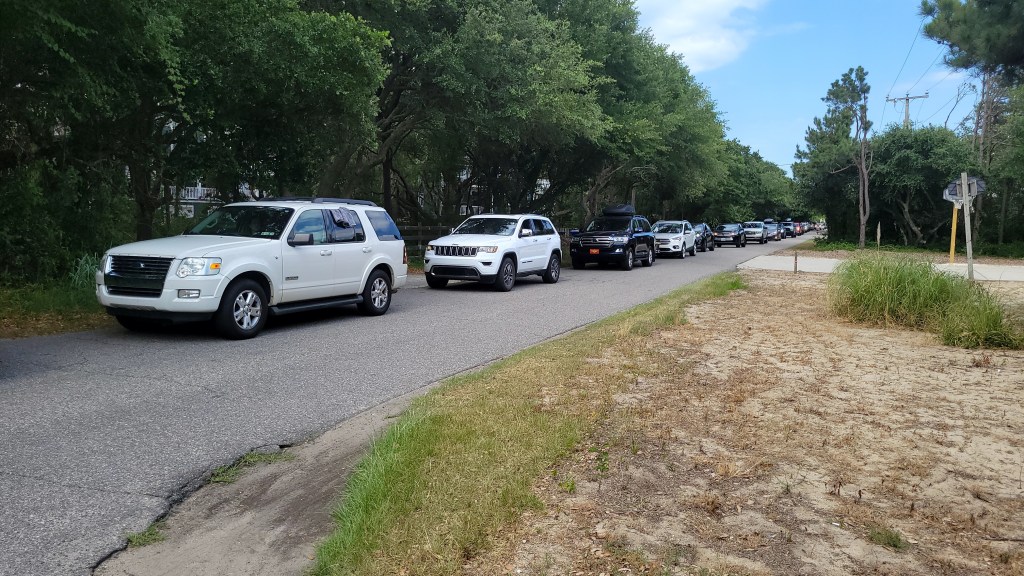
Northbound traffic backed up on Sea Oats Trail from its intersection with Duck Road. (Photo courtesy of a Southern Shores homeowner.)
Why doesn’t the Town enforce the “Road Closed/Local Traffic Only” signs that are beside the orange, water-filled barricades that block northbound traffic in every intersection of the Hickory Trail/Hillcrest Drive/Sea Oats Trail/Wax Myrtle Trail summer weekend cut-through route?
This is one of the recurring questions that angry residents have: What is the point of putting up signs and barricades and then not enforcing the “Local Traffic Only” regulation?
We have heard from Town Manager Cliff Ogburn numerous times as to why no enforcement occurs. He stated the reason again last Tuesday at the Town Council’s mid-month workshop meeting. (See The Beacon, 6/24/22 for a report.)
“The police cannot,” Mr. Ogburn said, “ . . . pull someone over or stop someone from going around those ‘local traffic only’ signs.
“They can’t pull someone over for suspicion,” he continued, “of not being a resident or having a right to that street.”
In addressing his officers’ lack of enforcement at the same meeting, Police Chief David Kole said about the barricaded roads: “They’re still public streets, and people have a right to traverse them.”
It would seem the Chief is not acquainted with N.C. General Statutes sec. 160A-296, which gives municipalities general authority and control over public streets, including the power to close any street temporarily and to “regulate the use” of public streets. (NCGS sec. 160A-296(a)(4) and (5).)
We revisit this area of contentious dispute again because yesterday we learned from Southern Shores homeowners on the scene that a woman walking her dog decided to block a stream of afternoon cut-through vacationers from turning left on to Hickory Trail by standing in the road. She turned herself into a mobile barricade.
While we appreciate this dog walker’s frustration, we do not recommend such protest or citizen enforcement. It is too dangerous.
We also agree with Mr. Ogburn that the police cannot pull motorists over on “suspicion” alone.
It is undeniable, however, that the Town of Southern Shores has legal authority to close and regulate use of its streets. Further, the “Road Closed/Local Traffic Only” signs are expressly sanctioned by the Federal Highway Admin. in its “Manual on Uniform Traffic Control Devices.” When violated, these “Local Traffic Only” signs can be enforced by local police with a citation, just like any other regulatory street sign.
The issue really is, when can police cite a motorist on the cut-through route with violating a sign that clearly tells him/her to take a different route unless he/she has no other option to reach his/her destination within the restricted area? In other words, when does suspicion become fact?
We submit that any northbound motorist who is in a backup of vehicles stopped at the intersections of Duck Road (N.C. Hwy. 12) with Sea Oats Trail, Eleventh Avenue, Hillcrest Drive, or Hickory Trail has violated one or more “Local Traffic Only” signs to get there and can be cited by a police officer for a traffic infraction. (If a local is among them and has a justifiable reason for being at the intersection, he/she can be quickly identified.)
We don’t need police officers at the entrances to barricaded roads, sometimes responding to tourists whom Chief Kole described sympathetically Tuesday as “upset” and “ticked off,” we need them at the outlets of these roads, issuing citation after citation to cut-through motorists stuck in gridlock in front of our residences. There’s no need to pull any vehicle over.
If such regulatory enforcement were to occur, we guarantee that northbound vacationers’ behavior would change. Few people want to start a vacation by receiving a traffic ticket.
And if they’re “upset” and “ticked off,” the police should tell them to take it up with Duck or Currituck County. We’re just keeping our roads safe.
FORMULATING A TRAFFIC PLAN
We have been working on formulating a different use of the barricades and “Local Traffic Only” signs along the cut-through route than what the Town Manager is currently doing.
Our plan is based on road closures, so it is a bit complex and would likely require the purchase of more barricades, an expense the Town Council has already approved. Until we have run our plan past some residents along the cut-through route, and received their support, however, we are not prepared to present it.
One aspect of it, however, we will promote now.
There is no reason for the section of Ocean Boulevard, from the Duck Road split to the Hickory Trail/Duck Road intersection, to be used as a “shortcut” around the congestion on Duck Road. Hickory Trail at Duck Road should be closed on summer weekends, as should Periwinkle Road at Duck Road.
We support continuing to place a “Local Traffic Only” barricade on Ocean Boulevard (around 142 Ocean Blvd.) in the northbound lane and would advocate putting a “No Outlet” or “Detour” sign on Ocean Boulevard just before East Dogwood Trail, so anyone who has been foolish enough to jump off the thoroughfare on to Ocean Boulevard is directed to the East Dogwood Trail/Duck Road intersection.
These road closures and rerouting might cause some backups on Ocean Boulevard initially, but they should dissipate as word gets out that this shortcut is not a shortcut. If they don’t, then we’ll revise our thinking.
Traffic backs up on Hickory Trail from Duck Road east to Ocean Boulevard last Saturday around 4 p.m. (Photo courtesy of a Southern Shores homeowner)
Responding to complaints about cut-through traffic from angry and frustrated residents, Mayor Elizabeth Morey admitted publicly for the first time Tuesday that the Kitty Hawk Town Council “declined to support implementing” the no-left-turn at the U.S. Hwy 158-South Dogwood Trail intersection this summer, “so, therefore, we’re not doing it.”
Ms. Morey also brought up at the Town Council’s Tuesday morning workshop—half of which was devoted to evaluating the Town’s traffic mitigation plan so far—overtures she made to Duck officials for help with moving weekend traffic through that town. Both Police Chief David Kole and Town Manager Cliff Ogburn contributed to this critical discussion about traffic.
Councilmen Leo Holland and Mark Batenic did not attend the meeting.
(The Beacon reported 5/13/22 on Kitty Hawk’s refusal to participate in the left-turn prohibition, which was in effect in 2020 and 2021 during the surging pandemic summers. For other background on the Town’s plan, see The Beacon, 4/27/22, 4/29/22, 5/10/22, and 5/15/22.)
In his presentation, Chief Kole first disputed complaints his department has received from residents on South Dogwood and Sea Oats trails about speeders on their streets.
“People’s perceptions are obviously sometimes misguided,” the Chief said, before citing average speeds on South Dogwood and Sea Oats that have been at or below the speed limit.
He also cited a vehicle count on South Dogwood Trail last Saturday that was nearly as high as the highest vehicle counts on that street last summer, when pandemic weariness and the no-left-turn were in effect. According to the Chief, 4200 vehicles traversed South Dogwood Trail on June 18, as compared with 4581 on July 4, 2021, and 4206 on July 11, 2021. (The 2021 dates were Sundays; perhaps he meant the Saturdays of these weekends.)
Sea Oats Trail apparently had 3,800 vehicles last Saturday, as residents there, the Chief said, were “getting slammed.
Town Manager Ogburn, who has been instrumental in trying to curtail cut-through traffic with the use of “local traffic only” barriers, characterized them as having had “less of a negative impact [last summer, for both residents and tourists] than they’re having now.”
Mr. Ogburn referred to residents’ “anger and resentment” toward the Town and to “conflict” and “tension” arising because of the orange, water-filled barriers, which themselves “are creating an issue.” (Both resident and non-resident drivers do like to move them and complain about them.)
Mr. Ogburn said, discouragingly, “I’m not sure they’re having the positive impact we would want.” He no longer believes, he added, that two of every 10 northbound vacationers are being deterred by them—a low threshold that he always thought made them worthwhile.
Chief Kole was blunter than the Town Manager about the barriers. They are “not working,” he told the three Council members.
“[Vacationers] are driving around the barricades,” he said, because “GPS is telling me to go” on a street that is either closed (as Hickory Trail was for two weekends) or closed to non-local traffic. Once one motorist transgresses, others follow suit.
The July 4th weekend is “going to be a hoot,” the Chief said. “Trust me.”
MAYOR’S COMMENTS
The Mayor made no mention of Kitty Hawk’s refusal to back the left-turn prohibition, which the N.C. Dept. of Transportation required before it would permit a blockage, at the Town’s April 26 public-information meeting on summer traffic mitigation.
She didn’t bring it up at the Town Council’s May 3 meeting, either, when Mr. Ogburn discussed the traffic plan/campaign endorsed by the Mayor, which is heavy on road signage and other communication designed to keep motorists on U.S. 158 and N.C. 12.
But the Mayor is now on the defensive because of complaints from what Mr. Ogburn referred to as “upset residents”—many of whom are calling the police—and she spoke as openly at the Tuesday workshop as we have ever heard her speak about the Town’s efforts to mitigate cut-through traffic.
At the April 26 meeting, she stated simply that the no-left-turn would not be in effect. Period. No explanation. She left the Town Manager to respond to questions about why not. On Tuesday she elaborated upon the safety problems that arose last summer, with the 7-Eleven being used as a turnaround and people making U-turns in the middle of U.S. 158, and mentioned traffic accidents at the 158-South Dogwood Trail intersection, although she didn’t quote any statistics.
Ultimately, however, she seemed to lay any blame on Kitty Hawk.
Also Tuesday the Mayor said she had reached out to “elected officials” in Duck, as she claimed Mayor Tom Bennett previously had, to ask them to reduce the number of pedestrians impeding traffic flow on Hwy. 12 during summer weekends.
These officials, she explained, “choose not to implement anything to mitigate the effect of pedestrians blocking the cars from moving through the Town of Duck in a faster, safe way.”
We wish the Mayor had told the public exactly what cooperation she sought because in explaining the officials’ decision, she mentioned pedestrians only at the “south end” of Duck.
Duck, she said, had a traffic study done of the south end, where the speed limit drops to 25 mph, and it concluded that “pedestrians aren’t the problem.”
We agree they’re not the problem at the south end; the speed limit is. We also guarantee that if you funneled all pedestrians on N.C. 12 in Duck from 13 crosswalks to three, the traffic would move faster. And if you put a police officer at each crosswalk, you would not have pedestrian stragglers holding up the traffic flow. It’s simple physics.
SPEEDING DISPUTE
In addressing speeding reports, Police Chief Kole told the Council that “We are continuously getting calls from certain people on South Dogwood that claim cars are going 50 mph, and at the same time it’s bumper-to-bumper traffic.”
The same, he said, is true on Sea Oats Trail: speeders, but bumper-to-bumper traffic.
We see no inconsistencies in these reports. Clearly, motorists can’t speed when the traffic is at a standstill, but they can, and they do, when the traffic opens up during non-peak hours on the weekends.
Average speeds obtained from radar don’t tell the tale. There is no way to know whether a northbound motorist travels at 50 mph at noon on a Saturday and a late-arriving motorist travels at just 15 mph or less at 4 p.m.
We were unable to view the speed data that the Police Chief displayed on overhead projection at Tuesday’s meeting because the videographer did not zoom in on them. Based on what Chief Kole said, we believe the data showed the weekly number of vehicles on these streets and the speed at which radar detected all of them.
Somehow Chief Kole was able to say that the average speed on South Dogwood Trail at the cemetery for one week when 8909 vehicles traveled there, was 25 mph. We urge the Chief to post his data on the Town website for all residents to see.
Chief Kole also offered the report of an officer who “conducted a lot of radar” on South Dogwood Trail last Saturday for proof that the average speed was 20 mph, and there were “no speeders,” but he did not say exactly when the officer patrolled the road. He wasn’t there for his entire 9 a.m. to 7 p.m. shift.
Apparently, when this officer, who was working overtime, according to Chief Kole, moved over to Ocean Boulevard at the Duck Road split, he and another officer were able to cite four or five motorists for speeding. This makes sense to us if the officers were near the SSCA parking lot just north the tower, where the speed limit drops to 25 mph, but the Chief did not say. He also didn’t give times for the citations.
‘TRAFFIC IS TRAFFIC’
Mr. Ogburn said that the vehicle counts on N.C. 12—from Skyline Road in the south to 13th Avenue in the north—“look relatively consistent from weekend-to-weekend” since Memorial Day. But the volume of traffic on the “northern end of town” is “increasing a lot.”
Mayor Morey attested that while she was out walking last Saturday around 3:30 to 4 p.m., she saw only one car turning left (north) from East Dogwood Trail through the Duck Road traffic light during a green cycle. Not good.
She again called upon rental property managers to arrange more Friday-to-Friday and Sunday-to-Sunday rentals, even though managers tell her, she said, “We already do that.”
“Do more” is the Mayor’s response, she said.
We wonder if the Mayor has looked at the rental numbers for the different turnover days. It used to be very easy in the uncongested old days to pick up a rental brochure (now called a vacation planner) from Southern Shores Realty Co. and see immediately which homes rented from Friday-to-Friday and from Sunday-to-Sunday. It now takes a more painstaking effort to separate them out from among the hundreds cataloged, but they are numerous.
The houses that SSR rents in Seacrest Village have long been Friday-to-Friday rentals. We counted 38 of them in SSR’s 2022 vacation planner.
We don’t think the turnover-day approach is a promising one.
Nor do we believe that advocating for the Mid-Currituck Bridge, which is on hold because of federal litigation, and filing an amicus curiae brief in the litigation between the NCDOT, the Federal Highway Admin., et al (there are multiple named appellee-defendants) and the non-profit anti-bridge groups represented by the Southern Environmental Law Center will speed up the construction process.
(The Town posted the amicus brief on its website today. Amicus curiae is Latin for “friend of the court.” The Town is not a party in the case, which is now in the U.S. Court of Appeals for the Fourth Circuit. The Town’s brief, which is joined by the Town of Duck, Currituck County, and other entities, essentially says we agree with the appellee-defendants’ argument, as did the lower U.S. District Court, which ruled in their favor on summary judgment. Summary judgment means that the NCDOT/FHA case is so strong that they are entitled to judgment as a matter of law, without having a trial.)
We respect attorneys who have a different opinion about filing this amicus brief, but we much prefer to consider practical, here-and-how traffic mitigation techniques. After the District Court’s ruling last December, the NCDOT announced a delay in the bridge project until early 2025. After that, pre-construction alone will take one year, according to the NCDOT.
Councilwoman Paula Sherlock, who has spearheaded the amicus brief effort, said Tuesday, “We are doing what we can do, but the traffic is the traffic.”
When asked by Mayor Morey whether he could think of any changes for improving the traffic, Chief Kole said, “I don’t have the answers. . . . But I can tell you that eventually we’re just going to have to say that we’ve done everything we can.”
We disagree with both of these conclusions. We’ve heard many other suggestions over the years—everything from speed humps to gates to police moving traffic along Hwy. 12, like a stadium event—but past Town Councils have ignored them.
Instead of discussing cut-through traffic at a 9 a.m. workshop with only 3/5 of the Town Council present, doesn’t it make more sense for the Town to hold a public forum to solicit ideas that it will actually consider? Or have we become so angry toward each other that we can’t even talk?
We all know the complaints are only going to multiply and get worse as the “after-school” crowd arrives and can legally turn left at South Dogwood Trail. Last summer we had the benefit of both staggered arrivals, because of remote school instruction, and the turn prohibition.
In explaining Kitty Hawk’s and Duck’s decisions to do their own thing, Mayor Morey reminded us that that’s democracy for you. Democracy is all we’re talking about here, too.
Mayor Morey will host a chat in the Pitts Center Wed., July 13, at 4 p.m.
The area outlined in red above is an undeveloped 7.9-acre commercial property tract in Southern Shores, part of which fronts on N. Virginia Dare Trail. (Courtesy of Dare County gis)
The Town Council recently unanimously approved a new mixed residential-commercial use of town property zoned commercial. Allowing “mixed-use” developments in Southern Shores, said Planning Board Chairperson Andy Ward, who spoke at the Council’s public hearing June 7 about the zoning text amendment that effected the change, “is a big leap for the town.”
Certainly, the Planning Board, which spent hours during the past few months thinking and talking about what was in the best interests of the town, thought so. The Town Council did not say much more publicly about the mixed-use concept than that members support it.
We said two weeks ago that we would explore this zoning change, which has the potential to land condos next door to, or on top of, retail shops, and the “issues and problems that arise” for us because of the decision-making process that led to it.
We have reviewed the videotape of the Town Council’s public hearing several times since June 7, as well as watched Planning Board meeting tapes, and thought more about what we heard and what we know and have concluded that:
A disconnect exists between the Planning Board and the Town Council, which makes us wonder how well they cooperate with, respect, and complement each other.
Mayor Elizabeth Morey and Mayor Pro Tem Matt Neal, who were busy “behind the scenes,” determined the critical content of the mixed-use amendment to the Town zoning ordinance, and the other three Council members, whose comments June 7 reflected a lack of familiarity with that ordinance and confusion about what they were doing, just went along.
With both the Planning Board and the Town Council focused on maximum allowable lot coverage for the new conditional use, both missed an opportunity to consider requiring “affordable” housing—what Dare County calls “essential and workforce housing”— with the mixed-use change in what is known as “inclusionary zoning.” At the very least, the Town Council should have publicly discussed the potential for mixed use in Southern Shores beyond what Ginguite LLC, the commercial property owner that sought the zoning change, wants to do.
We would like to stress to the Council members who were not included in the Mayor’s discussions with Ginguite and others before they voted June 7 on whether to approve its mixed-use ZTA that they have the option of motioning to table consideration of a ZTA.
Council members can (and should) take the time they need to understand what they are voting upon before they cast their votes. They’re making law!
FACTUAL BACKDROP
To authorize mixed use, the Town Council adopted at its June meeting a patchwork version of a ZTA that originated in February with Ginguite, a SAGA investor group that owns a marshy 5.2-acre commercial property at 6195 N. Croatan Hwy. (See The Beacon, 5/26/22, for background. We regret that we were on hiatus and did not track versions of this ZTA in the Planning Board.)
Ginguite purchased its property, which is adjacent to the Southern Shores Landing on U.S. Hwy. 158, in June 2014 with the expectation of developing it commercially, not residentially, according to SAGA Realty & Construction Co. Partner and CEO Sumit Gupta, who has been Ginguite’s principal representative. It had the option to do either.
Town Code section 36-207, which regulates the town’s C general commercial district, permits single-family, two-family (duplexes), and multifamily dwellings to be built in this district, per the standards of the high-density RS-8 multifamily residential district (section 36-203).
Sec. 36-207 also permits commercial “group” developments, with offices, retail stores, service establishments, etc., to be built. Until the Council approved mixed use two weeks ago, however, 36-207 it did not allow residential housing to be built with a commercial development on the same site.
According to Mr. Gupta, he met with Planning Director Wes Haskett earlier this year about developing the Ginguite tract, and the “consensus” that emerged from meetings he had with Mr. Haskett and other “town officials,” whom he did not identify, “was that the idea of bringing multifamily [dwellings] into group development was a good idea.”
For Ginguite to be able to combine residential and commercial uses on its tract, which has more than an acre of marshland and water and fronts on Ginguite Creek, it clearly needed sec. 36-207 to be amended.
The first ZTA (ZTA 22-02) that Ginguite submitted was skimpy. It proposed to add “group development of commercial and residential buildings” as a conditional use in the commercial district and specified only two conditions—one concerning the minimum building size, the other about connections between buildings—that a property owner would have to meet before being granted a special use permit.
The applicant assumed that pre-existing requirements imposed by sec. 36-207 on commercial property developments would carry over to the mixed use. The Planning Board, which was very concerned about the relative percentage of residential and commercial uses in a mixed-use development and about maximum allowable lot coverage, did not agree.
After a lengthy Q & A with Mr. Gupta, the Board voted to deny recommending ZTA 22-02, advising him that Ginguite could withdraw ZTA 22-02 and submit a new ZTA with some of the items they had discussed. Subsequently, Ginguite submitted the more detailed ZTA 22-06.
In the meanwhile, the Town Council enacted a maximum density requirement of eight dwellings per acre for residential development in the commercial district (ZTA 22-04). This is the same density requirement that applies to dwellings in the town’s RS-8 multifamily residential district. (Most of us live in the RS-1 single-family dwelling district.)
The Planning Board voted at its May 16 meeting to deny recommending Ginguite’s ZTA 22-06 because of a disagreement over lot coverage, and, in a highly unusual move, passed along to the Town Council its own version of ZTA 22-06 with its recommended requirements. The Board’s recommendations were not in a separate ZTA, but the Town Council treated them essentially as if they were.
It is unclear to us how often Mr. Gupta met with Town staff and “Town officials” privately during the past few months, but we do know that Mayor Morey, Mayor Pro Tem Matt Neal, and Town Manager Cliff Ogburn met with Mr. Gupta on the morning of the Council’s June 7 public hearing on ZTA 22-06 because the Mayor told us so.
After the Council approved the mixed-use zoning change in a manner most favorable to Ginguite, the Mayor said that this ZTA effort consumed “a lot of thoughtful discussions” and “required some work,” and she thanked the staff, the Planning Board, and Town Council members for their contributions. She did not mention the Town Attorney.
We believe that in seeking to accommodate Ginguite, the Mayor took her eye off of the potential for mixed-use developments in the Town as a whole. We also believe that on June 7, she presented a “done deal” that discouraged Town Council members not privy to these “thoughtful discussions” from exercising an independent judgment.
ZTA 22-06: SITE SPECIFICITY . . .
To our knowledge, no Town representative brought up the possibility of enacting inclusionary zoning with the zoning change, presumably because Ginguite did not seek it.
But ZTA 22-06 is not site-specific. It applies to the Town at large. We see no reason why the Planning Board could not have recommended against Ginguite’s ZTA 22-02 and prepared its own ZTA on mixed-use development, giving more than just lip service to affordable housing.
Mr. Gupta has pointedly said in public that any residential dwellings on Ginguite’s property will not be “workforce” housing; they will be “luxury” housing. Is this good planning policy for the Town’s future?
Inclusionary zoning is a term that refers to a host of different policies designed to set aside affordable housing in new developments (sometimes a percentage of “below-market” units). It is one of the tools by which municipalities nationwide are addressing the shortage of workforce housing. We wish the decision-makers in Southern Shores had considered it.
The point about site-specificity caused two Town Councilmen some difficulty during the Council’s deliberations on ZTA 22-06. One repeatedly asked if the ZTA applies to all commercial properties, or only to the Ginguite’s. Another asked whether what the Council was thinking about approving would allow the applicant “to do what he wants to do,” to get what he’s “asking for.”
It is discouraging to hear such confusion and wrongheadedness from Town government officials in deliberating an important town-wide zoning change.
Mr. Gupta told the Council that although a site plan for Ginguite’s property has not been prepared, a “design” has been circulated that envisions a “charming village” of luxury condominiums—with a walkway along Ginguite Creek, where boats could be launched—with small commercial buildings.
We question the appropriateness of circulating that design. It should have had no bearing on the Town Council’s deliberations.
Inasmuch as that design was viewed by Town employees and representatives, in their public capacity, however, we believe it should have been included in the hearing materials provided.
Mr. Gupta assured the Council that Ginguite’s “intention” is not to enhance the value of the property with the mixed-use development potential and then sell it. Ginguite’s intention is not relevant to the Council’s deliberations, either.
We have learned on Dare County GIS that the Ginguite property was zoned residential when Boddie-Noell Enterprises, Inc., which includes the Kitty Hawk Land Co., sold it for $1 million in 2003 to the Northern Outer Banks Associates LLC. We do not know whether it was zoned then for RS-8 multifamily dwellings or for RS-1 single-family dwellings.
According to online data, the Northern Outer Banks Associates LLC incorporated in 2003 and dissolved in 2016. Its principal address and agent were in New Bern.
Ginguite LLC bought the property in 2014 from the Wells Fargo Bank—in default?—for $535,000. By then, the 5.2-acre tract had been zoned commercial. Unfortunately, we do not have time to research how that happened, but it does seem like Ginguite LLC got a bonanza.
. . . AND MAXIMUM LOT COVERAGE
The maximum allowable lot coverage of the new mixed-use group development conditional use in the commercial district was the major sticking point between Ginguite and the Planning Board and the Planning Board and the Town Council.
The requirements for the mixed-residential and commercial conditional use now appear in the Town Code as Section 36-207(c)(11), which sets forth the minimum building size, setbacks, lot coverage, and other conditions that must be met for a property owner to obtain a mixed-use special permit. The majority of these conditions are standards already in the Code sections for the commercial district and the RS-8 multifamily residential district.
The Council adopted some of the recommendations made by the Planning Board, but only one of them is not already in the Code. It rejected the Board’s recommendation about buildable lot coverage, which the five-member volunteer Board spent months “deliberately” considering, according to Mr. Ward.
The maximum lot coverage permitted currently in the Town’s RS-8 multifamily residential district is 40 percent of the net parcel area; the maximum lot coverage in the commercial district is 60 percent of the total parcel area, although that can be increased to 67 percent if the developer uses a sufficient amount of permeable pavement.
The Planning Board arrived at what Mr. Ward called “a pretty good average of 50 percent” lot coverage for the mixed-use conditional use by “blending” the maximums allowed in the RS-8 district and the commercial district.
Mayor Morey and Mayor Pro Tem Neal disagreed with the Board’s 50 percent, which the Board also decided could be extended to 55 percent with permeable pavers. They endorsed the 60 to 67 percent maximum lot coverage permissible in the commercial district.
The Planning Board also wanted to calculate all mixed-use lot coverage according to the “net” parcel area, the standard used in the RS-8 residential district. Net area is obtained after deducting acreage deemed unbuildable by “waterways, marshes, or wetlands.”
Not surprisingly, Mr. Gupta opposed this limitation on Ginguite’s commercial property, viewing it as a penalty for including residential uses in any development it might propose. Ms. Morey and Mr. Neal agreed with Mr. Gupta. They thought that mixed-use lot coverage should be calculated on the basis of the “total” parcel area, and they prevailed.
Mayor Morey led off the Council’s discussion about ZTA 22-06—and, thereby, steered it—with the pronouncement: “This is a commercial development, and we’re pulling in dense residential into it.” She wasn’t blending anything.
She then framed, and, thereby, limited, the choices before the Town Council by saying either it should vote to 1) impose the 60 percent maximum lot coverage standard applied in the commercial district or 2) use total parcel area in calculating a maximum lot coverage below 60 percent.
So framed, the Town Council’s discussion on lot coverage did not veer from these choices.
Mixed use, said Mr. Neal, is a “new concept,” but it is a conditional use in the commercial district, not a separate zoning district, so commercial district standards should generally apply.
“If you make the restrictions [on mixed use] so much that the use wouldn’t even necessarily be utilized,” said Mr. Neal, who is a builder, “there’s no point in doing it.” (Just what is the point in doing it?)
In a conciliatory nod to the Planning Board, the two Town Council leaders endorsed the Board’s recommendation that the residential footprint in a mixed-use group development be a minimum of 25 percent of the net parcel area.
A COUNCIL OF TWO
We do not wish to discredit the other three Town Council members, but they were not actively involved in the discussion of ZTA 22-06 and at various times showed hesitancy and confusion.
We wish that Town Councilwoman Paula Sherlock, who said she was “torn” between Ms. Morey’s two choices, had trusted her instincts and pursued her reasoning. She questioned whether the Mayor’s and Mayor Pro Tem’s position vis-à-vis the Planning Board’s position on lot coverage was “really a compromise,” but she did not say anymore. We would have preferred a real discussion, one that gave some consideration to the Planning Board’s “thought process,” as Mr. Ward called it.
We also believe it would have been beneficial for the Council to have talked about the other commercial properties in town that now may be developed with a mixed use.
They include the 18.1-acre Marketplace and a 7.9-acre vacant property, with the address of 5391 North Virginia Dare Trail, that is only partially visible from the road. This tract is owned by the Stone family, owners of Southern Shores Realty Co. (SSR), Southern Shores Crossing, and other commercial properties. SSR owns a number of vacant residential lots in Chicahauk (Wild Pony Lane, Spindrift Trail) that are either adjacent to or in the vicinity of the 7.9-acre tract.
We were always dismayed by the previous Town Council administration’s penchant for bringing “done deals” to Council meetings and not enlightening the public about the negotiation and discussion process that culminated in those deals.
“Done deals” short-circuit public discussion and discourage members of the public from participating in hearings. Why bother to comment if a decision has already been made?
If Mayor Morey is going to continue this practice—and Mayor Pro Tem Neal is going to assist her in doing so—the least they can do is fully disclose the meetings they held off-the-public-meeting record and the nature of their decision-making process. What factors did they consider? We believe the public has a right to know. So does the Planning Board, whose decisions have increasingly become superfluous.
We also believe that all Town Council members have a duty to be prepared and informed enough on town issues—especially those concerning zoning—to exercise an independent judgment and to elucidate just what that judgment is. That means doing homework, not just winging it. We would like to hear from all Town Council members that they know what they’re talking about.
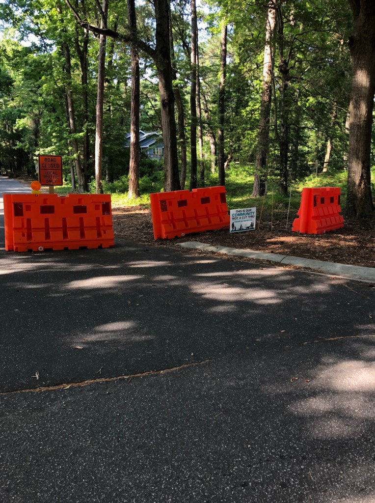
The “local traffic only” barriers that have been in place since Memorial Day weekend will remain in effect this weekend, and Hickory Trail will not be closed at East Dogwood Trail, according to the summer traffic mitigation update in yesterday’s Town newsletter.
The following locations will have orange water-filled barriers in place to block northbound traffic that is not local:
Hickory at East Dogwood Trail
Hickory and Wax Myrtle
Hickory and Sea Oats
Hickory and Hillcrest
Hillcrest and Sea Oats
East Dogwood and Wax Myrtle
East Dogwood and Sea Oats
East Dogwood and Hillcrest
Juniper Trail past the Food Lion entrance
Ocean Blvd. at the southern end near the Duck Road split
If you are not currently a Town newsletter subscriber, we encourage you to sign up at https://www.southernshores-nc.gov/broadcast-news/. The electronic newsletter is published biweekly on a Friday.
Please feel free to share on this blog your observations about today’s cut-through traffic. This weekend is the first of the summer high season, and unlike the past two summers, arriving vacationers will be able to turn left legally at the U.S. Hwy 158-South Dogwood Trail intersection. We will be interested to hear how the traffic flows or doesn’t flow.
Be safe, everyone.
HAPPY BIRTHDAY, SIR PAUL
We also would like to wish a happy 80th birthday today to the “cute Beatle,” Sir Paul McCartney.
Anyone who thrilled to the Beatles’ “Ed Sullivan Show” performances in 1964 and then lived the magical mystery tour of Sir Paul’s musical life, which continues with a U.S. tour this summer, has to feel a bit numb and awestruck about this milestone birthday.
It’s been 16 years since Sir Paul turned 64, and we still need him. Long live the Fab One.
The revisions to the Southern Shores solid waste ordinance adopted by the Town Council April 5 do not require residents to place their trash and recycling receptables in the street right-of-way only within 24 hours of collection and to remove them by midnight after collection.
Just as the former Town Code section (26-5) that deals with placement and maintenance of receptables did, the revised ordinance recommends this timing for rollout and rollback—using the verb “should,” not “shall”—it does not mandate it. Residents and rental property owners are not at risk of being cited for a Code violation if they or their renters put their cans on the roadside too soon or leave them out too long.
But, after hearing worried and/or confused residents express concern over being cited for a violation for rollback failure, we decided to step in and clarify the “should-shall” of receptacle etiquette.
The intent of Town Code Amendment 22-02, which the Town Council adopted unanimously at its April regular meeting without holding a public hearing—as it is legally entitled to do—is 1) to prevent roadside litter caused by trash and recycling receptacle overflow and by receptacles without lids and 2) to prevent receptacles from becoming road obstructions. It is not to punish residents for leaving their trash or recycling cans out too long, according to some people’s sense of aesthetics, although it would rather you did not.
The following changes made by the Town Council to Chapter 26 are mandatory requirements:
*Trash and recycling receptables shall be placed within the street right-of-way within three feet—an increase from two feet in the former ordinance—of the pavement, and three feet of clearance—a decrease from four feet—shall be left around the containers.
(If you place the receptacle too far from the street, we can assure you that Bay Disposal will not empty it. Too close to the road and it becomes an obstruction.)
*All residential receptacles shall have “fully functional lids that cover the entire receptacle” and “fully functional wheels.”
(This is a new requirement. We strongly support the put-a-lid-on-it movement!)
*Residential units of four bedrooms or fewer that “are offered for vacation rentals” shall have at least three solid waste receptacles—an increase from two in the former ordinance—and two recycling receptacles—an increase from one; and residential units of five or more bedrooms that are offered for vacation rentals shall have at least five trash receptacles—an increase from three—and three recycling receptacles—up from one.
(Having been a rental property owner for more than 30 years, and having family history with the Southern Shores rental business dating back 50 years, we believe these numbers are excessive for many rental houses, and the Town Council should have been more discriminating. The “offending” houses that always have overflowing trash and recycling cans in front of them (see above) are well-known to us seasoned veterans. Requiring all owners of five-bedroom rental houses to have five trash receptacles and three recycling receptacles strikes us as an increase of can clutter. We also believe that the previous number of cans required for four-bedroom or fewer rental houses was more realistic.)
*Residential occupants shall be responsible for maintaining the roadside pickup area clear of debris and vegetation. (This is not a new requirement. We just believe it is worth noting.)
Inasmuch as the foregoing are mandatory requirements, they are enforceable and punishable by a civil penalty. Chapter 26 requires the Town to issue the property owner of record a warning citation and subjects the property owner to a fine if the Town must issue subsequent notices of violation. (The ordinance imposes a $50 fine upon first notice after a warning; $100 on second notice; $150 on third notice and for additional violations in a 12-month period.)
TCA 22-02 also specifies that solid waste or recyclable materials that are placed outside of the receptacles will not be collected and that the property owner of record is subject to a civil penalty for such debris, after first receiving a warning of a violation.
While the Town now has stickers available that read either “Trash Only” or “Recycling Only,” and indicate with arrows which side of a receptacle should face the street, residents are not required to affix them to their receptacles.
New Town Code section 26-5(e) states that “every residential receptacle should be labeled with a town issued sticker,” not that it shall be so labeled.
We think the stickers are a good idea for receptacles at rental units, where, inevitably, guests position them backwards on the street. You may pick up the stickers at Town Hall for no cost.
RECYCLING PICKUP ON FRIDAY IS A TERRIBLE IDEA
The only real bone we have to pick with the Town’s solid-waste changes is the shift in the recycling pick-up day from Wednesday to Friday.
There is no worse day for recycling pickup at rental houses, which typically rent from Saturday to Saturday, than Friday. It is well known to us seasoned veterans that renters depart in a semi-conscious whirlwind of activity, putting trash and recycling out at the last minute, if they put them out at all.
I manage both a Friday-to-Friday rental and a Saturday-to-Saturday rental and am not convinced that the new Friday recycling pickup helps me with either.
Only the most organized and fastidious renters will put their recycling out on Thursday night and then only if the “property owner of record” papers the house with notices asking them to do so. And maybe not even then. Even the good-as-gold repeat renters who have been coming to the same cottage for 20 years and leave a lovely message in the logbook may slip up and forget. Renters enjoy every disengaged moment they have until Saturday’s (or Friday’s) frenzy.
I share with you my experience last Saturday of checking on the 51-year-old, four-bedroom family rental cottage that I now own with my three siblings: I arrived around 10:30 a.m. to find the front door to the house wide open—seriously, the renters were too much in a hurry to close and lock the door—and the trash and recycling cans next to the house, a long driveway’s walk from the roadside.
The trash can had balloons and other party inflatables in it that I burst before I wheeled it down to the road for Monday’s pickup. The recycling can, which I sorted for nonrecyclables, was three-quarters full. Now we have another, but can I reasonably expect the next renters to roll out the previous renter’s recycling?
In all of my years as a rental property owner, I have never known renters to dispose of any disposables except their own, so tomorrow evening, I will be trying to drop by the house unobtrusively to roll out the nearly full recycling can left by last week’s vacationers.
This is not something that my siblings and I can ask our rental company agent to do for us. It never has handled rollout, even when it claimed it did. Being local I know when the agent’s claim that “the housekeepers roll the trash to the road” is simply not true.
Bay Disposal protested in the past that it could not handle both trash and recycling on the same collection day. Clearly, it can. How about double-booking the collector on Monday, so we can rid ourselves of renters’ recyclables two days after they depart, rather than six? A return to the Wednesday pickup would be preferable to what exists now.
We are aware of the horrendous traffic conditions yesterday on the South Dogwood Trail cut-through route and have read residents’ comments on Next Door. We elected not to cover the traffic, as we have every summer since we began publishing in 2018, because it’s old news. Déjà vu. And the déjà vu is only going to get worse now that the left-turn prohibition on U.S. 158 at South Dogwood Trail has been abandoned.
(For a report on why the no-left-turn was abandoned, see The Beacon, 5/13/22. Kitty Hawk has jurisdiction over the left-turn lane and declined to support the prohibition, but the Southern Shores Town Council had no problem with that decision because it believes faulty data purporting to show that the prohibition produced no benefit.)
We know from experience that signage doesn’t work; people ignore it. We also know that barricades don’t work as long as people can drive around them.
Yesterday morning we found out about a half-hour after Hickory Trail was closed at East Dogwood Trail that people who do not know each other will get out of their vehicles and work together to move heavy water-filled barricades enough so that they can drive their vehicles past. Seriously. We talked to homeowners who saw the maneuver.
The police had to restore the intersection and then waste their time explaining to drivers who ignored the “STOP DEAD END NO OUTLET” sign (see above) at Hillcrest Drive/Hickory Trail that they could not go through. That includes disbelieving locals who didn’t want to turn around.
Amazingly, there are people who don’t understand that taking the next block over will usually get you around a road closure. Apparently, detour signs need to be posted if the Hickory Trail closure is going to continue.
We can assure everyone who commented on Next Door that all of the traffic-calming and traffic-controlling ideas that they raised—for example, installing speed humps on certain residential roads and convincing the Town of Duck to reduce its 13 crosswalks to a less disruptive number on summer weekends—have been suggested by residents. In eight years of lobbying the Town Council, we have been very thorough in identifying all manner of techniques to discourage and/or prevent cut-through traffic.
Installation of the road closure/local traffic only barriers last summer was a big step forward, but without the left-turn prohibition, it is questionable how effective they will be. Judging from comments on Next Door, they were not very effective yesterday.
We hope everyone knows that a citizens’ committee on cut-through traffic, chaired by homeowner Tommy Karole, recommended a gate on South Dogwood Trail near the elementary school that could be raised by a transponder attached to Southern Shores property owners’ and guests’ vehicles. The professional traffic engineers that the Town Council hired to study the traffic patterns and congestion in Southern Shores also recommended a South Dogwood Trail gate and other permanent physical impediments.
The bottom line is, as the traffic consultants told the Town Council, N.C. Hwy. 12 operates over-capacity in Southern Shores on summer weekends, and northbound motorists are going to seek a way around the gridlock, regardless of what signs direct them to do or not do.
We understand Southern Shores residents’ frustrations and invite you to express yourself here, rather than on Next Door, which is not Southern Shores-specific.
Water-filled barriers and signs sit at the ready on Hickory Trail at East Dogwood Trail this evening, when the northbound lane was already restricted to “local traffic only.” Not shown in the photograph are two more orange barriers sitting on the other side of the road. You can expect Hickory Trail to be closed this weekend.
The Southern Shores Town Council unanimously approved Tuesday a new mixed residential-commercial use of town property zoned “C general commercial” and an $8,790,776 town budget for fiscal year 2022-2023, which is $87,638 over the budget that Town Manager Cliff Ogburn initially recommended on May 3.
Town Attorney Ben Gallop also announced his resignation, effective July 6, at the Council’s Tuesday meeting—which was a lengthy session that lasted nearly two and a half hours because of the hearing on the mixed-use zoning text amendment (ZTA).
The addition of mixed-use developments in the Southern Shores commercial district was first proposed in ZTA 22-06, which was submitted to the Town and later revised by Ginguite LLC, a SAGA investment group that seeks to develop a 5.2-acre tract on U.S. Hwy. 158 with both residential and commercial facilities. The current Town Code does not permit both uses on the same property. (See The Beacon, 5/26/22 for background.)
In amending Town Code sec. 36-207(c) to add this new conditional use in the commercial district, and specifying building requirements for mixed-use developments, the Town Council broke with the Town Planning Board’s recommendation over the maximum lot coverage that should be allowed.
The Council decided to allow mixed developments the same maximum lot coverage as all-commercial developments, which is 60 percent, but can be up to 67 percent if a certain percentage of permeable pavers is used (to allow for ground water absorption). The Planning Board recommended capping lot coverage at 50 percent, with an increase to 55 percent, if permeable pavers are used.
We will explore this zoning change and the Town Council’s and Planning Board’s decision-making process, and the issues and problems that arise for us, in a forthcoming column.
In other business Tuesday, Mr. Ogburn reported that all traffic barriers will be in place along the residential cut-through routes, and Hickory Trail will be closed at East Dogwood Trail, this weekend. N.C. DOT’s mobile message boards advising arriving visitors to stay on U.S. 158 and N.C. 12 also will be in use, he said.
Mr. Ogburn also updated the beach nourishment timeline for Southern Shores, saying that “We’re just kind of waiting in line,” for sand to be pumped in Kill Devil Hills and Kitty Hawk before it is pumped on our beaches, which now appears will be in early August.
At the start of its meeting, the Town Council heard a presentation by Outer Banks Visitors Bureau Executive Director Lee Nettles and Dare County Tourism Board Chair Tim Cafferty about a proposed 48,275-square-foot, $18 million event center to be built at the Soundside Event Site in Nags Head.
The Soundside site is on the 158 bypass next to Pamlico Jack’s Restaurant, which would be demolished to make way for an indoor facility to host sporting events, banquets, concerts, “galas with speakers,” and “smaller conventions,” according to Mr. Nettles, who also referred to the proposed facility as a civic center.
According to Mr. Nettles, this project jibes with the “mission” of the Tourism Board, which is “to promote the Outer Banks during less-than-peak months,” thus encouraging “year-round tourism,” which is not necessarily a goal of local residents or visitors who come in what is considered the off-season.
Mr. Nettles also noted that the center will be designed to “have equal appeal and value for people who live here as well as the visitors.”
The Outer Banks Visitors Bureau Director said the magic word, pickleball, several times in touting the sporting events that would be held in the center, which is designed to have three basketball courts end-to-end as well. (See below for more talking points.)
Mr. Nettles and Mr. Cafferty held a public forum on the project in Nags Head on Monday (See The Outer Banks Voice article) and have spoken to Kill Devil Hills town officials, trying to drum up support. The Nags Head Board of Commissioners will have to approve zoning changes in order for the plan for the event center to advance.
FY 2022-23 BUDGET
After further workup by the Town Council and the Town Manager after the latter’s initial May filing, the town’s new fiscal year budget increased in expenditures by $87,638, from a recommended budget of $8,706,138 to an adopted budget of $8,790,776.
The bulk of that increase is an additional $80,000 transferred out of the Capital Reserve Fund to be used for canal maintenance, an amount that Mr. Ogburn raised from $20,000 to $100,000 for the year. In subsequent years, the Town Manager said, $50,000 will be allocated for canal maintenance.
No one on the Town Council mentioned property taxes during the public hearing that it held on the budget, and no town residents spoke.
In his closing remarks of the meeting, Mayor Pro Tem Matt Neal observed that, thanks to ample town tax revenues, the Council did not have any tough decisions to make about the FY 2022-23 budget, which will likely not be the case in FY 2022-23, when property taxes may have to be raised.
To balance the FY 2022-23 budget, the Town Council approved a transfer of $365,309 from the town’s unassigned fund balance.
The Town Council also unanimously approved by a separate motion and vote an increase in the town’s fee schedule for permits and other costs, which Mr. Ogburn said had not been increased since 2012.
NEW TOWN ATTORNEY
Mr. Gallop announced Tuesday that his law firm, Hornthal Riley Ellis & Maland LLP, will continue to represent the Town, and that firm partner, L. Phillip Hornthal, III, will be its primary counsel. Mr. Gallop will be leaving his firm and going into solo practice, he said.
Mr. Gallop also announced that he has initiated lawsuits against five Southern Shores oceanfront property owners who have not granted the Town voluntary easements on their property for purposes of beach nourishment and that he plans to file the Town’s amicus curiae brief in the mid-Currituck County Bridge litigation on June 13.
Mr. Gallop further said that he would be “looking at” the Town’s proposed new sign ordinance, which has been knocking around since last year. The Planning Board gave the ordinance its best shot; we believe Mr. Gallop should have intervened and fixed the ordinance months ago.
CUT-THROUGH TRAFFIC
The experiment with closing the Hickory Trail-East Dogwood Trail intersection over the Memorial Day weekend led to myriad problems, Mr. Ogburn said at Tuesday’s meeting, including southbound motorists ignoring the “No Outlet” signs at Hickory Trail and Hillcrest Drive, and, therefore, having to turn around at Hickory-East Dogwood; northbound motorists driving onto the grass to go around the orange, water-filled barriers; and people even attempting to remove said water-filled orange barriers!
The police had a busy Saturday over the holiday weekend, but Police Chief David Kole did not elaborate upon any of the details in his monthly report.
During our own on-the-ground reporting, we witnessed southbound locals trying to convince the police that they should be an exception to the “no outlet” signage and be permitted access to and from Hickory Trail and an apparently inebriated man trying to move one of the barriers. We also are aware of efforts by neighbors to block the grassy areas next to the barriers with stakes and flags.
Mr. Ogburn said that more water will be added this weekend to these barriers, which will be increased in number, and more signage will be posted to convince southbound motorists that Hickory Trail really is dead-ended.
TALKING POINTS FOR EVENT CENTER: Among the talking points offered by Mr. Nettles and Mr. Cafferty to promote the new event center are the following:
*It will bring in $25,250,000 in “new spending.” (But there will be no profit for the first three to five years.)
*It will generate more than 14,000 new “room nights” annually.
*It will create 191 new jobs, including nine full-time positions at the center itself.
*It will have a culinary training kitchen so that local people, especially students, will have an opportunity to acquire culinary skills.
*Its event hall will be 26,000 square feet; the meeting room will be 1,500 square feet; the training kitchen will be 2,800 SF; and the lobby, restrooms, halls, and back-of-house space for employees, storage, etc., will be 17,975 SF.
*It will host events with crowd sizes between 300 and 2,500 people. (No conventions.)
FINALLY, PLEASE NOTE: The recycling pick-up day has been permanently changed to Friday. From now until Labor Day, there will be two trash pickups in town, one on Friday and the other on Monday. We will return to once-a-week Monday trash pickups after the summer season is over.
This aerial view of Southern Shores from Dare County gis shows Ginguite LLC’s tract at 6195 N. Croatan Hwy. outlined in red.
The Town Planning Board voted last week to recommend to the Town Council the creation of a mixed residential-commercial use of property located in Southern Shores’ C commercial zoning district, with specific requirements and conditions that builders of mixed-use developments must meet.
The recommendation came about at the Planning Board’s May 19 meeting, as a culmination of extensive discussions between Town staff and the Board with Ginguite LLC, a SAGA investment group that seeks to develop a 5.2-acre tract next to Southern Shores Landing on U.S. Hwy. 158 with both residential and commercial facilities.
The Southern Shores Town Code of Ordinances currently does not permit such mixed-use developments.
(Because of The Beacon’s six-month suspension, we did not follow discussions between Ginguite and the Planning Board at public meetings. We are catching up.)
Mixing residential and commercial uses on a single property in the commercial district is essentially “creating another zoning district,” said Planning Board Chairperson Andy Ward at the Board’s meeting last week, during which Sumit Gupta, representing Ginguite LLC, sought the Board’s recommendation of a Zoning Text Amendment—ZTA 22-06—that his company submitted to authorize and define mixed-use developments.
The Board unanimously rejected ZTA 22-06, because of a disagreement over lot coverage, then recommended its own conditions for mixed-use developments in the commercial district.
Ginguite has not presented a site plan for the vacant property at 6195 N. Croatan Hwy., which has both marshland and water on it, but Mr. Gupta, who is a Co-Founder, Partner, and Chief Executive Officer of SAGA Realty and Construction, told the Planning Board last week that the developer is considering designs with “luxury multifamily” dwellings, similar to the Run Hill Luxury Apartment Villas owned by SAGA in Kill Devil Hills.
“Affordable, workforce housing,” said Mr. Gupta, “is not [our] focus.”
Although Mr. Gupta addressed only the Ginguite property on U.S. 158, any amendment to the Town Code to allow mixed-use developments would apply to all commercial properties in Southern Shores. There are three others, according to Planning Director and Deputy Town Manager Wes Haskett. They are:
*5391 N. Virginia Dare Hwy., 7.9 acres (the Stones’ property, which includes the Southern Shores Realty office, the Southern Shores Crossing, and vacant land)
*5500 N. Croatan Hwy., 18.1 acres (the Marketplace)
The Town Code currently allows as “permitted uses” in the commercial district a variety of retail stores, business, financial, and professional offices, service establishments, and residential dwellings, among other facilities, and authorizes certain “conditional uses,” including group developments of commercial buildings. (See Code sec. 36-207)
The residential dwellings it specifically permits are detached single-family dwellings, two-family dwellings (duplexes), and multifamily dwellings.
(The Town Zoning Ordinance is codified at section 36 of the Town Code of Ordinances. We sometimes refer to the Zoning Ordinance or the Zoning Code when referencing section 36.)
A mixed-use group development of commercial and residential buildings was clearly not contemplated by previous Zoning Code writers, who kept apartments and other multifamily housing units separate from retail shops and other commercial facilities.
Chairperson Ward described ZTA 22-06 as the “fourth version” of efforts between the Planning Board and Mr. Gupta (Ginguite) to reach agreement on the requirements and conditions of a new mixed-use group development. Both ZTA 22-06, which the Planning Board considered insufficient, and the Board’s own recommendation amend the Code to make mixed-use group developments a conditional use in the commercial district.
While Mr. Ward said the ZTA “versions” that Ginguite has presented “keep getting better,” a major sticking point between the Board and Mr. Gupta—one that consumed an inordinate amount of time at the May 19 meeting, as communication broke down—was the maximum allowable lot coverage for a mixed-use development.
MAXIMUM LOT COVERAGE FOR MIXED-USE
Ginguite’s ZTA 22-06 provides that “no more than 40 percent lot coverage of the net parcel area” can be associated with residential building footprints and required residential parking. It does not address commercial lot coverage, however, which, if a certain amount of permeable pavement is used, can be up to 67 percent, according to Town Code sec. 36-207(d)(5)(b).
The Town Code currently allows a maximum of 40 percent lot coverage for multifamily dwellings in the commercial district, but not for single family homes or duplexes, which are limited to 30 percent coverage. (Sec. 207(c)(4))
Mr. Gupta argued last week that a developer of a mixed-use property should be able to use the maximum lot coverage permitted for commercial property, provided its residential buildings and parking do not exceed 40 percent of the net parcel area.
He seemed to view residential property as a “substitute” for commercial property, saying: “It would be nice to take some of the allowable commercial space and trade it for residential.”
Mr. Ward took a different approach, advocating that the maximum allowable lot coverage of the net parcel area should be evaluated in the aggregate, without regard to whether a building/structure footprint is residential or commercial, and proposing a maximum of 50 percent.
Board Vice Chairperson Tony DiBernardo further advanced the idea that a minimum lot coverage should be set for residential development. He cited a minimum of 25 percent and a maximum of 40 percent lot coverage of the net parcel area.
(There has been much discussion about mixed-uses behind the scenes, as well as at previous Board meetings, and we are unsure when these percentages arose and who originated them.)
The Town Zoning Ordinance defines “net” acreage as the total area to be developed, “minus any area covered by waterways, marshes, or wetlands.” (Code sec. 36-57) The Ginguite property has all three.
Mr. Gupta said the Board’s aggregate 50 percent lot coverage “penalized” Ginguite “for bringing in residential” development.
The investors’ group bought the property on U.S. 158 in June 2014, and, according to Mr. Gupta, “The plan was to develop it within the current rules,” meaning strictly commercial, “which we can still do.”
He declined to agree with the 50 percent mandate at last week’s meeting, saying “Our current plan wouldn’t work” with it, and, further, that the “net” parcel area restriction “hurts us.”
RECOMMENDED REQUIREMENTS FOR MIXED-USE DEVELOPMENTS
As part of its recommendation to the Town Council, the Planning Board set forth requirements for future mixed-use developments, which pertain to allowable building size, residential density, and other common dimensional regulations in addition to lot coverage. They were largely culled from other sections of the Zoning Ordinance, but some are new. We quote them verbatim below:
*Minimum size of any building shall be 2,500 square feet. (This was in Ginguite’s version of the ZTA.)
*All buildings constructed within 35 feet of another building within the development are to be connected by a breezeway or covered walkway. (Also in Ginguite’s ZTA.)
*Lot shall be serviced by an existing community wastewater treatment facility permitted by NC DEQ DWR. (N.C. Dept. of Environmental Quality, Division of Water Resources. Also in Ginguite’s ZTA.)
*Residential density shall be limited to RS-8 District allowances as established in Town Code sec. 36-203(a). (Note: The density requirement in the RS-8 multifamily residential district is eight dwelling units per net acre. The Town Council enacted this requirement, which was initiated by Mr. Haskett, at its May meeting. Ginguite agreed with it.)
*A minimum of 25 percent and no more than 40 percent lot coverage of the net parcel area can be associated with building footprints containing residential uses and the required parking for residential uses.
*Minimum front yard (setback): 25 feet.
*Minimum side yard (setback): of 15 feet. An additional 5-foot-yard adjacent to the street is required for a corner lot.
*Minimum rear yard (setback): 20 feet.
*Maximum building height shall be 35 feet, measured from the average of the existing, undisturbed grade at the building corners
*No building or other facility (such as parking spaces, incinerators, trash collection areas, etc.) shall be located nearer than 50 feet to boundaries of residential districts
*Where a mixed use group development abuts a residential zone, a buffer of dense vegetative planting or natural vegetation is required (see Sec. 36-207(8))
*Maximum allowance lot coverage of the net parcel area by principal use and all accessory structures, in the aggregate, for the entire mixed use group development, shall be 50 percent.
*Mixed use group developments which incorporate the use of permeable pavement, as outlined in Section 36-207(d)(5)(a), in excess of 5 percent of the total lot coverage shall be allowed a maximum allowable lot coverage by principal use and all accessory structures, of no greater than 55 percent. (This compares with 67 percent if the development is strictly commercial.)
According to Mr. Haskett, the Town Council will hold a public hearing on ZTA 22-06 at its June 7 meeting, and he will report that the Planning Board recommended denial of it, as presented, but recommended approval of it with these additional conditions.
30% LOT COVERAGE IN RS-1 DISTRICT: Before the Planning Board considered mixed-use development, it took action on ZTA 22-05, which was an application by Stacia and Marc LeBlanc of 9 Tenth Avenue, to increase maximum allowable lot coverage from 30 percent to 35 percent for nonconforming lots in the RS-1 residential district of Southern Shores.
The Planning Board unanimously denied the LeBlancs’ application, although Board member Robert McClendon said he would consider increasing lot coverage throughout the district to 35 percent.
The LeBlancs’ lot on Tenth Avenue is 17,500 square feet, 2,500 square feet smaller than what is considered a conforming lot in Southern Shores. They built their 3,330-square-foot house, swimming pool, and other outdoor structures in 2020 and ran up against the 30-percent limit when they tried to add decking and walkways of their choice.
The LeBlancs argued their case for changing the lot coverage in a well-organized Power Point presentation that predominantly focused on how a change would benefit them and did not address how it would affect the town as a whole.
In evaluating the ZTA, Mr. DiBernardo said, “I just don’t see how this helps Southern Shores one bit. I don’t see any positive. . . . It will take away from the environment and also make lots look more crowded and closer together. . . . It might help individuals, but it doesn’t help the town as a whole.”
He later added, “Aesthetically and environmentally, there’s no plus to it.”
Planning Board member Lynda Burek said that there should be “no surprise [to property owners] if you’re over lot coverage” because of the permitting process. The Town will not approve building plans that are not in compliance with the Town Code.
Chairperson Ward, whose opinion has been key in defeating efforts to expand building lot coverage by exempting from its calculation certain structures (such as 500 square feet of a swimming pool), gave a history of the limitation, noting that the 30 percent restriction dates to 1981, when the first Town Code was enacted.
He also illustrated numerically how the benefit of a 5 percent gain in lot coverage increases as nonconforming lots get smaller. (See his chart at the 35-minute mark of the videotape.)
“We are slowly relaxing lot coverage,” Mr. Ward told the LeBlancs, “but we’re doing it very incrementally.” The Board, he said, is “protective” of Southern Shores.
SHOUT-OUT: We would like to conclude this report by giving an appreciative shout-out to Councilman Matt Neal, who attended all 2 hours and 40 minutes of the Planning Board’s May 19 meeting. Thank you, Councilman Neal. You are a dedicated and informed public official.
Mr. Ward’s description of the lengthy meeting as “a little bit better than a root canal” was spot-on, and you didn’t budge from the endodontist’s chair.
We also thank Stasia LeBlanc for giving The Beacon a shout-out when she said that she and her husband did not anticipate the negative response that their ZTA would receive.
Even “The Beacon is complaining about it,” she said.
We’re glad she’s reading us. Next time, perhaps, we’ll be on the same side.
The Town Planning Board unanimously voted (5-0) at its meeting yesterday to recommend denial of the two zoning text amendment (ZTA) applications featured in a Beacon post Wednesday—one about increasing maximum lot coverage on lots that are smaller than 20,000 square feet and the other about amending the Town Code to accommodate a mixed-use commercial-residential development—according to Planning Director and Deputy Town Manager Wes Haskett today.
We refer you to our May 18 post for details about ZTA 22-05 (lot coverage) and ZTA 22-06 (conditional use in the commercial district). We were unable to attend the Planning Board meeting because of commitments out of town and would welcome comments by anyone who attended or live-streamed it.
Planning Board chairperson Andy Ward has been a strong proponent in recent years of keeping the maximum allowable lot coverage in the RS-1 residential district (single family dwellings with “abundant open space”) at 30 percent and not chipping away at that percentage by exempting swimming pools and other ground structures from square-footage calculations.
We would have been very surprised if he had endorsed an expansion of allowable lot coverage for nonconforming lots, i.e., those that are smaller than the standard minimum lot in Southern Shores of 20,000 square feet.
We will follow up with a longer report later. We are writing now only because of the great interest our Wednesday post had among readers, especially those on Facebook.
Unless the applicants withdraw their proposed ZTAs, they will go to the Town Council for de novo consideration. The Council is not bound by the five-member Planning Board’s decisions, but it is heavily influenced by them.
We are aware of a recent extended conversation on Next Door about changes in the Town’s solid-waste regulations. We also will address these changes in an upcoming post, as well as the concern expressed by some Next Door subscribers that they were not informed about the changes until they were a done deal.
Questions: How can the Town better inform residents? Should the Town spend the money for a USPS-mailed notice to all property owners about changes to regulations of fundamental services, such as solid waste and recycling collections?
Questions: Do you read the Town’s biweekly newsletter and check the Town website for news? Do you attend Town Council meetings or watch them on videotape?