
The Town is in the process of rewriting the lot width requirement in all zoning districts to make it “less ambiguous,” as Planning Director Wes Haskett explained at the April 17 meeting of the Planning Board, which considered a first draft of a revision and voted unanimously to “send it back” to Town staff for “more work.”
The revision is Zoning Text Amendment (ZTA) 23-03, which you may access here: https://www.southernshores-nc.gov/sites/default/files/fileattachments/planning_board/meeting/3042/zta-23-03_lot_width.pdf.
For about 50 minutes Monday, the Planning Board considered this simple definition in ZTA 23-03, without reaching consensus on it or on an acceptable substitute:
Lot width means “the minimum horizontal distance between the side lot lines of a lot measured from the front lot line at right angles to the rear lot line.” (A revision of the definition in Town Code sec. 36-57.)
In the RS-1 single-family residential district where most Southern Shores homes are located, ZTA 23-03 provides that the minimum lot width is 100 feet measured “from the front lot line at right angles to the rear lot line.” (A revision of Code sec. 36-202(d)(2).)
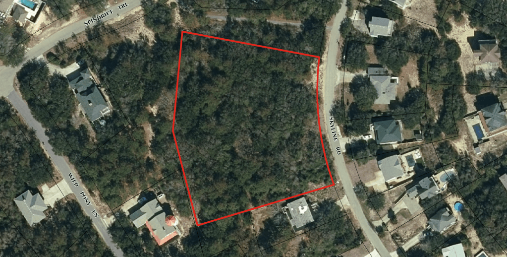
The Town Council requested this ZTA after it reversed a decision by the Board of Adjustment last October against property owners operating as Skyline Oaks Properties LLC (“Skyline Oaks”) who sought to recombine an 80,000-square-foot tract land at 55 Skyline Road into four smaller buildable parcels. Skyline Oaks’ proposal essentially constituted a subdivision of the property.
(See The Beacon, 10/1/22, for background.)
Although each of the new lots would measure 100 feet in width, their configuration persuaded Mr. Haskett, serving in his capacity as Zoning Administrator, to deny approval of Skyline Oaks’ recombination plat because it would create nonconforming lots in violation of the lot width requirement in the RS-1 residential district.
In reaching his decision, Mr. Haskett applied the current language in sec. 36-202(d)(2), which states that the minimum lot width of 100 feet is to be measured from the “building setback line measured at right angles to depth.”
The “building setback line” is defined in Code sec. 36-57 as a line that is “parallel to or concentric with the street right-of-way establishing the minimum allowable distance between such right of way and the nearest portion of any building.”
Lot “depth” is defined in the same Code section as “the average distance from the street line of the lot to its rear line measured in a general direction of the side lines of the lot.” (Our emphasis added.)
Confusing matters further, the current definition of lot width in sec. 36-57 is “the width of a lot at the required building setback line measured at right angles to depth.”
In a written decision, Mr. Haskett explained how he interpreted the applicable ordinances and calculated the 100-foot width: “[A]ll of the proposed lots,” he wrote, “should have a minimum width of 100 feet measured at a line that is parallel to and 25 feet from the current right-of-way, Skyline Rd.”
He essentially interpreted the building setback line to be the same as the front setback line, which, in the RS-1 district is 25 feet.
The Board of Adjustment is a quasi-judicial body comprised of members of the Planning Board. Among its functions, it hears appeals by property owners from administrative decisions by the Town, such as the denial of Skyline Oaks’ recombination.
After a hearing on the merits, the Board agreed, 3-2, with Mr. Haskett’s interpretation of the ordinances, and the property owners appealed its decision to the Superior Court of Dare County.
The Beacon attended the Board’s Oct. 5 hearing on Skyline Oaks’ appeal, but did not report on its outcome—in large part because the Town Code analysis was so convoluted.
The main issue for the Town, for whom Mr. Haskett testified, was that two of the four lots the property owners proposed to create were behind two lots that fronted on Skyline Road. They, therefore, did not have building setback lines, as he defined that term.
In an action that was not publicly reported and only sketchily referred to by Mr. Haskett at Monday’s Planning Board meeting, the Town Council intervened to enter into a consent decree with Skyline Oaks, resolving the matter in its favor. The Council overruled Mr. Haskett’s interpretation, allowing the property owners to proceed with their recombination.
As we learned at Monday’s meeting from Planning Board member Robert McClendon, who is one of the principals in Skyline Oaks and, therefore, recused himself from the Board of Adjustment hearing, the Town did not pay the limited liability company’s legal fees.
ANALYZING DRAFT ZTA 23-03 AND MEASURING LOT WIDTH
We agree with the Planning Board that the language of ZTA 23-03, which Mr. Haskett said Monday the Town Attorney had approved, is not sufficient. It does not clear up the ambiguities of the current measurement scheme; it just creates new ones.
We do not agree, however, with an apparent majority of the Board who, nonetheless, told Mr. Haskett, in an informal poll that he took, that they like what is in ZTA 23-03.
Curiously, when Mr. Haskett asked the Board, “Do you all think that what’s in the language [of ZTA 23-03] now should remain?”, he observed that three members said yes.
The same three replied favorably to Mr. Haskett’s follow-up question as to whether “the lot width language in the [proposed] ordinance should stay as it is.”
Board Vice-Chairperson Tony DiBernardo, who ruled in favor of Skyline Properties at the Board of Adjustment hearing, clearly said, “Yes, with some work.” Mr. McClendon also expressed his approval of the ZTA’s language.
New Board member Jan Collins, a former alternate, seemed unsure as to what Mr. Haskett was asking, asking him in return what other possibilities they could consider. (The Planning Board is free to draft whatever language it would like as a replacement.)
Planning Board Chairperson Andy Ward adamantly disagreed, and we believe Ed Lawler also said, “No,” although his response was not audible on the meeting videotape.
The Planning Board was stymied in its discussion Monday by the reality that many lots in Southern Shores are irregularly shaped and not uniformly 100 feet wide from side-lot-line-to-side-lot-line at all locations.
Mr. Ward, who was the most vocal in opposing the language of ZTA 23-03, offered one such lot for the Board’s consideration: Located on a cul de sac in town, it is shaped like a cone, not a rectangle, with more than 100 feet of width in the rear of the lot and less than 100 feet of width in the front.
It is well known that lots in Southern Shores were platted before the community became an incorporated town in 1979 and enacted a Town Code with minimum requirements for lot dimensions. Non-conformities exist and are permitted.
In its discussion, the Planning Board considered replacing the proposed lot width definition with one that uses an average of widths on a lot to arrive at the 100-foot minimum; but no consensus developed around this approach.
The problem that we have with the proposed language in ZTA 23-03 is that it does not offer a reference point to calculate a right angle. The front lot line and rear lot line are typically parallel with each other, not perpendicular, so what does it mean to measure width from the front lot line “at right angles” to the rear lot line? Clearly, depth is involved, but the language doesn’t refer to depth.
We consulted the American Legal Publishing, whose attorneys and editors have been assisting municipalities with ordinance codification for nearly 90 years. According to our online research, American Legal offers the following definitions for lot width and lot depth:
WIDTH: “is the horizontal distance between the side lot lines, measured at right angles to the lot depth at a point midway between the front and rear lot lines.”
DEPTH: “is measured along an imaginary straight line drawn from the midpoint of the front property line of the front property line of the lot to the midpoint of the rear property line.”
If depth runs vertically and width runs horizontally, a right angle can be achieved and measured.
What these definitions do is put the lot width measurement at the midway depth point between the front and rear lot lines.
Whatever the Planning Board—and the Town Council, in time—decide to do about defining lot width, we strongly recommend that they streamline the applicable ordinances so that lot width is only defined in sec. 36-57, and the width requirements in the ordinances for each zoning district refer only to the minimum number of feet. Thus, if you consulted Code sec. 36-202(d)(2), you would learn that the minimum lot width is 100 feet, but you would have to read the definition of lot width in sec. 36-57 to know how the 100 feet are measured. A referral to sec. 36-57 could be inserted next to the lot width requirement for each zoning district.
As it is now, if you consult the width requirement for the RS-1 residential district, you learn that it is “100 feet (measured at the building setback line).” You then have to look up what the “building setback line” is—the confounding definition of which we quoted above—and, for good measure, consult the definitions in sec. 36-57 for “lot width” and “lot depth”! It’s too much.
It is also important to keep in mind that the Town has a minimum lot size requirement in RS-1 of 20,000 square feet—although there certainly are smaller developed lots. (See Code sec. 36-202(d)(1)) The area and width requirements are supposed to combine to preserve the low-density nature of Southern Shores’ residential neighborhoods, which is the underlying point of all of the minimum dimension requirements.
THE NEXT PLANNING BOARD MEETING WILL BE MONDAY, MAY 15, AT 5 P.M. IN THE PITTS CENTER: The Board has a heavy agenda that day, according to Mr. Haskett, and may or may not resume its discussion of ZTA 23-03.
ANN G. SJOERDSMA, 4/20/23
