9/7/19: ‘PRIORITY TWO’ PERSONS MAY REENTER NORTHERN OBX AT NOON TODAY, AS DARE BEGINS STAGED REENTRY; SOUTHERN SHORES STREETS CLEARED FOR ACCESS; Hatteras Island Remains Closed

hickorytree
This photograph of a downed tree across Hickory Trail was taken this morning shortly before a tree-removal crew arrived to clear it.

“Priority two” permanent Dare County residents and essential personnel for critical businesses may return to areas north of Oregon Inlet today starting at noon, as Dare begins its priority reentry staging.

In a bulletin issued at 9:30 a.m., the Dare County Control Group advised that it has started the reentry process for the northern towns, including Southern Shores, but has continued to keep access to Hatteras Island closed until further notice. The county has established a checkpoint to restrict entry to Hatteras Island.

According to the bulletin, the Control Group “will continue to meet to assess conditions and implement reentry for additional priorities as conditions improve and power is restored.”

See Dare County Emergency Management (DCEM) bulletin at https://www.darenc.com/Home/Components/News/News/5604/1421?backlist=%2fdepartments%2femergency-management.

Priority two permanent residents must present a valid N.C. driver’s license or a government-issued ID card with a local address in an area north of Oregon Inlet in order to gain access. Essential personnel of critical businesses must present a priority two reentry permit with a matching government-issued ID, according to the Control Group’s advisory.

Priority one applies to essential personnel; priority three applies to nonresident property owners and employees at non-critical businesses; and priority four encompasses all visitors, including renters who have booked vacation cottages starting today.

Based on my experience and my observations, I do not envision the Control Group moving into priority four reentry until tomorrow. Priority three reentry could occur later today.

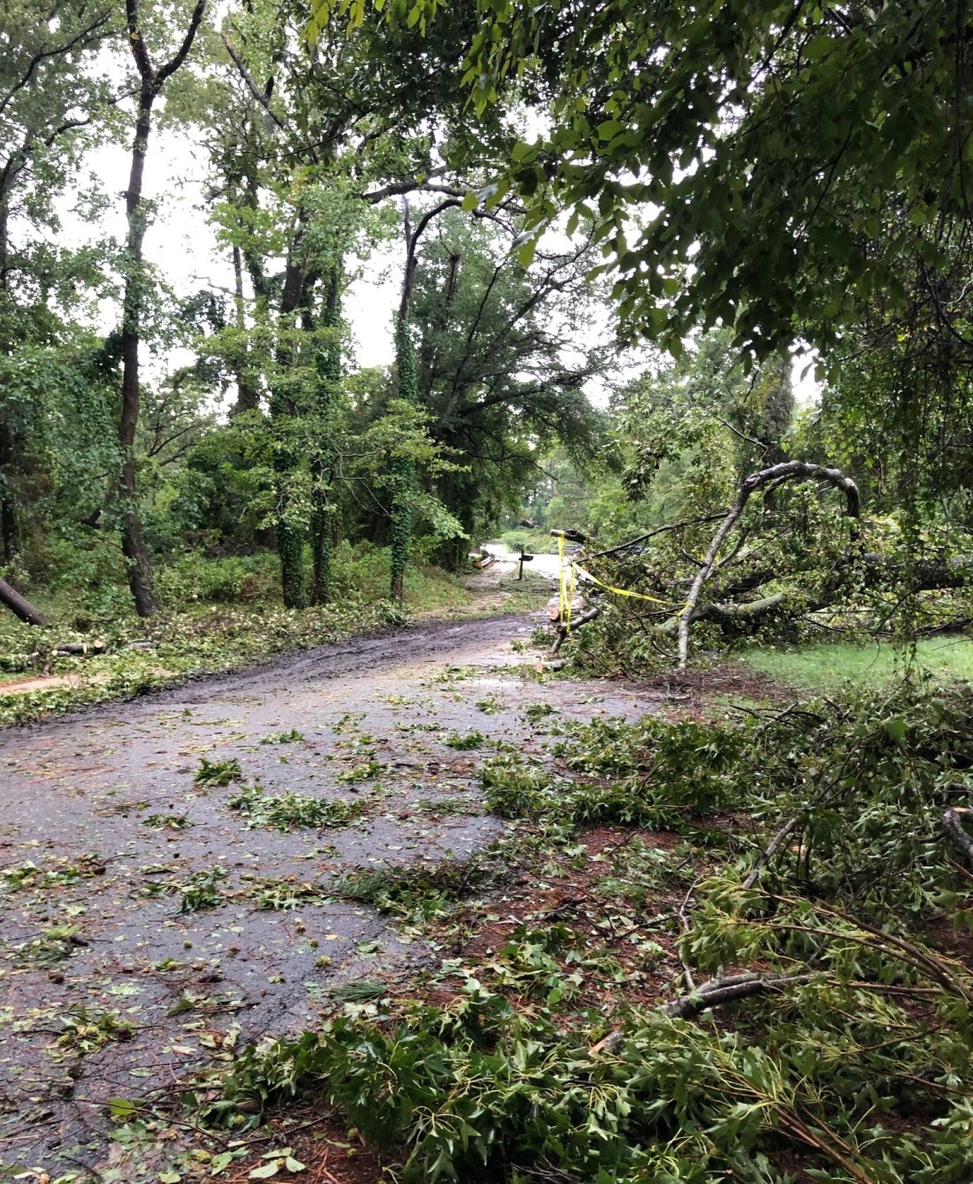
According to the DCEM bulletin, Southern Shores streets have been cleared for access. Town staff will be assessing the storm-generated debris and providing debris-removal information as soon as possible. As for our neighboring towns:

The bulletin advises that, although a town-wide damage assessment has not been completed in Duck yet, the damage there appears to be minor, just some minor siding, roof, and fence damage. N.C. Hwy 12 and all side roads in Duck are passable, despite some standing water and tree debris.

The DCEM bulletin did not provide details about conditions in Kitty Hawk, but notes that traffic signals are inoperable in parts of Kill Devil Hills and Nags Head. Generally speaking, standing water, tree limbs, and debris still remain on some roadways in the towns south of us.

There will be no ocean swimming today because of dangerous surf conditions and strong rip currents.

To obtain detailed information about the staged reentry process and to apply for a permit, which you can print out, visit http://www.darenc.com/reentry.

Ann, 9/7/19


9/6/19: MANDATORY EVACUATION, RESTRICTED ACCESS TO DARE REMAIN IN EFFECT UNTIL TOMORROW MORNING, WHEN STAGED REENTRY WILL BE DECIDED; Curfew Set for Hatteras Island


11thave1.jpg
Surf’s up on the beach at 11th Avenue, and the road to reach it remains passable, with very little standing water, according to SSCA President Rod McCaughey, who submitted this photo. Nearby houses, he reports, only suffered minor shingle damage.

The mandatory evaluation for Dare County remains in place because of hazardous conditions, and access to Dare County remains restricted, until the DCEM’s Dare County Control Group meets tomorrow morning to review safety assessments and determine reentry procedures.

In a bulletin issued at 4:35 p.m. today, Dare County Emergency Management described existing hazards as including “downed power lines and trees, impassable roadways, and widespread power outages.”

Southern Shores definitely experienced downed trees, impassable roadways, and some power outages, but they appear to have been largely in the woods, according to what readers have reported to The Beacon. Like Rod McCaughey, who photographed the ocean at 11th Avenue, Nancy Lorell of 13th Avenue saw a “very high and angry” ocean when she ventured to the beach this afternoon.

Ms. Lorell described “some ponding” on her street, “but not as bad as Matthew,” which caused widespread flooding on the oceanside three years ago. Thirteenth Avenue also has “some small limbs and leaf debris” on it, “but nothing major,” Ms. Lorell said.

eastdogwood.jpg
A single lane is passable on East Dogwood Trail near its intersection with Hickory Trail, thanks to quick work by the SSVFD which, according to neighbors, cleared a number of downed trees from the roadway.

Roadways on Hatteras Island are covered with sand and water, DCEM reports, and N.C. DOT is working to assess damage along N.C. Hwy. 12 there.

All of Hatteras Island is without power, just as is Ocracoke Island, which is in Hyde County, not Dare. Water service to Hatteras Village has been turned off due to a leak that cannot be found and repaired because of flooding. Repair crews are standing by.

The Dare County Control Group has established a curfew for Hatteras Island from 8 p.m. through 8 a.m. tomorrow. It applies to all areas south of Oregon Inlet.

The Control Group will determine the timing for the staged reentry process, which, as The Beacon previously described, will occur according to the “priority” status of returning persons.

Essential personnel may return first during stage one. Resident property owners who have the proper identification or a reentry permit may return during the priority two stage; nonresident property owners with proper ID must wait until priority three stage. Priority four applies to the general public and all other visitors. For more information about the reentry process, see https://www.darenc.com/departments/emergency-management/hurricanes/reentry.

If you would like to receive a DCEM alert via text, voice mail, or email, you may sign up at http://www.darenc.com/alerts.

(UPDATE MINUTES AFTER POSTING THIS: A reader reports that the AT&T cell tower at the Duck Road-Ocean Boulevard split was damaged during the storm.)

Ann, 9/6/19

9/6/19: THE CLEANUP STARTS AS DORIAN HEADS OUT TO SEA

firetruck2.jpg
The SSVFD attends to tree obstructions near the intersection of East Dogwood and Hickory trails.

I heard the sound of a chain saw emanating from East Dogwood Trail, looked outside a window and saw a Southern Shores Volunteer Fire Dept. truck and the blue lights of a police car at the intersection of East Dogwood and Hickory trails, and decided to violate curfew by a few minutes. My neighbor had already started some sort of motorized device and was chopping wood. I could not resist.

No one is cutting through on Hickory Trail this afternoon.

After photographing the East Dogwood-Hickory trails intersection, I walked north to take a photo of this obstruction, which Lynanne St. Laurent reported earlier on The Beacon’s Facebook page:

hickorytrail.jpg
A downed tree blocks Hickory Trail, going north, before Red Bay Lane.

As of 2 p.m. today, Hurricane Dorian was 125 miles northeast of Cape Hatteras and heading north out to sea at 21 miles per hour, according to The Weather Channel. With sustained winds of 90 mph, it is still a Category 1 hurricane. Our friends in Virginia Beach are now feeling its effects.

The roads in the Southern Shores woods that I have been able to see in person or in photographs sent to me are littered with tree debris. It is foolish to travel them now, but that reality has not stopped a few cowboys in pick-up trucks from venturing out.

Dare County asks residents to report loose and downed power lines to law enforcement (911) or the power company.

I would love to hear from someone on or near the oceanfront who can describe the damage in that area. Please email ssbeaconeditor@gmail.com or post a comment on the Facebook page.

How are folks in Chicahauk doing? In the dunes? Your observations and comments are welcome.

Ann, 9/6/19

9/6/19: CURFEW EXTENDED UNTIL 3 P.M. TODAY, EXCEPT IN NAGS HEAD

The curfews established yesterday for all areas of Dare County except Kitty Hawk have been extended until 3 p.m. today, except in Nags Head, where the curfew has been lifted, according to a noontime bulletin from the Dare County Emergency Management.

I have been adding updates to previous posts and to The Beacon Facebook page via comments.

Ocracoke was hit hard this morning when the waters of the Pamlico Sound rose 7 feet in two hours, starting around 8 a.m. There is widespread flooding on the island, as well as a power outage. Hatteras island is also without power and experiencing flooding.

I will add to this post when I have further updates about the curfew and damage in Southern Shores.

Ann, 9/6/19


9/6/19: SCENES FROM OCRACOKE, SOUTHERN SHORES

ocracoke.jpg
These photographs were taken in Ocracoke at 10 a.m. today.

Pamlico Sound waters at Ocracoke rose 7 feet in two hours this morning, starting around 8 a.m., according to a report by The Washington Post:

https://www.washingtonpost.com/weather/2019/09/06/water-rises-feet-hours-ocracoke-north-carolina-eye-hurricane-dorian-moved-past/

Curritucksound
A view of the Currituck Sound at North Dogwood Trail in Southern Shores, around 11 a.m.


9/6/19: HURRICANE DORIAN MAKES LANDFALL AT CAPE HATTERAS; DCEM Advises All Residents to Stay Indoors Today, Warns of Soundside Flooding

flashflood
Graphic published by National Weather Service

Hurricane Dorian made landfall at Cape Hatteras at 8:35 a.m. today, according to the National Weather Service. Its winds were estimated at near 90 miles per hour, making it a Category 1 hurricane.

Closer to home, a northeast wind of 26 mph, and gusts of 39 mph, were registered at 9:15 a.m. in Manteo at the Dare County Regional Airport, according to the National Weather Service.

A flash-flood emergency is in effect for the Pamlico Sound in Hyde and Dare counties. (See graphic above.) I just received a report from a reader in Ocracoke that some people there have knee-deep water in their homes.

(Update: People are stranded in Ocracoke, inundated by flood waters and without power. The Cape Hatteras Electric Cooperative reports on Twitter that the electricity is out throughout Hatteras and Ocracoke islands. Repairs to broken transmission poles will not occur until the area is deemed safe for workers to enter.)

Dorian is continuing to move northeastward, but its speed has increased to 14 mph.

Dare County Emergency Management advises all residents to “stay indoors, shelter in place” throughout today, as the storm’s strong winds and heavy rains affect our area.

In a bulletin issued this morning at 7:45, DCEM also warns that water levels on the sounds are dropping, as “water is pushed away by the wind,” but when the winds shift, “the sound water will rapidly return, bringing extreme soundside flooding.”

Those of us who live on or near the Currituck Sound have witnessed this phenomenon before. DCEM advises that you may access flood gauges online to view water levels in real-time at fiman.nc.gov.

Contact information for reporting power outages and viewing power outage maps, etc., is available at darenc.com/hurricanedorian.

For updated weather forecasts, watches, and warnings from the National Weather Service, see http://www.weather.gov/mhx.

Please feel free to comment here on the conditions in your area. If you would like to send a photograph, please email it to ssbeaconeditor@gmail.com.

Stay safe!

(A reminder: The curfew is still in effect until noon and may be extended.)

Ann, 9/6/19


9/5/19: CURFEW IS IN EFFECT FROM 8 PM UNTIL NOON TOMORROW, All Dare County Towns Except Kitty Hawk; At 6 pm, Eye of Hurricane Dorian Was 45 Miles Southeast of Myrtle Beach, Traveling 8 mph NNE

piebold.jpg
A doe and her piebald fawn graze in a yard on East Dogwood Trail this evening. Although piebald deer are rare, they are more common than albino deer, which lack all body pigmentation and have pink eyes, noses, and hooves.

Curfews are in effect in all areas of Dare County, except for the Town of Kitty Hawk, starting at 8 p.m. today and continuing through noon tomorrow, according to the most recent bulletin from Dare County Emergency Management. There also will be no access into Dare County starting at 8 p.m.

See: https://www.darenc.com/Home/Components/News/News/5593/1421?backlist=%2fdepartments%2femergency-management

As of 6 p.m., the eye of Hurricane Dorian was located 45 miles south of Myrtle Beach, S.C., The Weather Channel (TWC) reported.

The category 2 hurricane, which has had winds ranging from 105 mph to 115 mph today, according to TWC’s Mike Bettes, is moving 8 mph north-northeast. In describing Dorian’s projected track, Mr. Bettes said the hurricane will “skirt” the South Carolina and North Carolina coastlines until it reaches Cape Hatteras, where it will “pull away” and move out to sea.

The Weather Channel is forecasting a storm surge of 4 to 7 feet and rain amounting to 4 to 6 inches for the northern Outer Banks.

Rain has just become heavy in Southern Shores–at 6:35 p.m.–after periods of light rain alternated with bursts of sunshine throughout the afternoon, starting around 2 p.m.

(By 7 p.m., the rain had slacked off.)

I drove down the 158 Bypass around 5:30-6 p.m. and found only one restaurant open in Kitty Hawk: Shipwrecks, which is just south of Wings and across the street from the Mobil station, where the pumps were still operating. Barefoot Bernie’s, long a holdout during storms, was closed.

Quite a few Dominion Power and Spectrum trucks were parked at the Hilton Garden Inn, which was open for business.

The wind was blustery, but not strong, on the beach at the nearby Kitty Hawk Pier. The ocean, which was at low tide, had moderate-size waves–nothing that remarkable (yet).

TWC’s Mr. Bettes said we will be through with Dorian, and it with us, by midday tomorrow.

I am going to take my sighting of the piebald fawn, which I saw with his/her mother and more skittish sibling on my return to the Southern Shores woods, as a harbinger of good tidings. Have a peaceful night, everyone.

UPDATE FROM DARE COUNTY EMERGENCY MANAGEMENT AT 7 P.M.:

https://www.darenc.com/Home/Components/News/News/5595/1421?backlist=%2fdepartments%2femergency-management

The bottom line: Time to hunker down.

Ann, 9/5/19


9/5/19: THE DAY BEFORE DORIAN: Harris Teeter Expected to Be Open Until 6 p.m.; Bear Drugs at least until 5 p.m.

walmart
If you need last-minute supplies, head to Harris Teeter, not Walmart.

If you need supplies from Home Depot today, you have until noon before the Kitty Hawk superstore closes. It will be closed tomorrow also, according to signs on the store’s doors, and open on Saturday, if possible.

Nearby, Harris Teeter, which enjoyed a brisk business this morning, will be open today probably until 6 p.m., according to the store’s florist, Maggi, who told me that a closing time had yet to be announced.

As you can see from the photo above, Walmart has battened down its hatches.

If you need a prescription filled, Bear Drugs owner and head pharmacist, Steve Archbell, said he plans to put in a full day. If “winds start to pick up,” Mr. Archbell said, he will close at 5 p.m., rather than the usual 7 p.m.

The ABC Store is closed today and tomorrow. Han-Dee Hugo’s BP gas station is still open.

If you would like to grab a fast-food lunch, McDonalds is still serving. Wendy’s is not.

If you’re a news junkie like me, you will not find today’s print newspaper for sale anywhere, not even The Virginian-Pilot.

As for the weather, it’s still hot, humid, and overcast with occasional bursts of sunshine.

Walkers are enjoying the deserted, but calm Southern Shores beaches. The wind is mild. It’s a beautiful day.

I’ll update the forecast later. (The Weather Channel is currently focusing on Charleston, S.C. The watch words for the northern Outer Banks continue to be storm surge.)

Have a great day.

Ann, 9/5/19

9/4/19: ACTUAL PICTURES OF DORIAN IN SOUTHERN SHORES: Beaches Are Wide-Open, Supermarkets Are Busy; Post Office Is Closed

edogwood2
The Southern Shores beach at the E. Dogwood Trail access around 12:30 p.m. today. Some people are nonchalantly soaking up the sun.

It is hot. It is humid. It is overcast, with occasional bursts of sunshine. The beaches are scarcely populated and wide-open. Beautiful, despite the red “No Swimming” caution flags fluttering in the breeze. The road traffic is steady, but much lighter than usual at this time of year. Construction crews are working. Harris Teeter in Kitty Hawk is doing a booming business . . .

This is Southern Shores on the Wednesday before the arrival of Hurricane–or, more likely, Tropical Storm–Dorian, the day that Dare County ordered permanent residents to start evacuating.

Judging from the number of grocery carts I observed loaded with bottled water, beer, and wine, I would say that quite a few people are not heeding the “mandatory” order.

FOR YOUR INFORMATION:

Grocery stores: Harris Teeter is open its regular hours today, which means 24/7, according to an employee I asked on-site. Walmart is doing the same. Already shuttered, Food Lion in the Marketplace is closing at 8 p.m. and will not reopen until Saturday.

Pharmacies: CVS and Walgreens are closed. Bear Drugs is open until 7 p.m. I suspect Walmart’s pharmacy is open until 9 p.m., but I did not confirm this.

Gas is available at the Han-Dee Hugo’s in Kitty Hawk.

The Southern Shores Town Hall is open today until 5 p.m. It will be closed Thursday and Friday.

The Kitty Hawk Post Office closed at the end of business yesterday. There will be no mail delivery today.

All bets are off for tomorrow. Enjoy!

noswimming2

Ann, 9/4/19


9/4/19: A PICTURE OF DORIAN IN THE OUTER BANKS ON WEDNESDAY; You May Still Cross the Wright Memorial Bridge Today Without Being Restricted

hatchlings.jpg
The Southern Shores beach at the site of one of the two remaining unhatched sea turtle nests was unpopulated today. The tire tracks bear witness to patrols by Ocean Rescue.

Good morning, everyone.

And so the wait begins.

In all of my decades of living and vacationing on the Outer Banks, I cannot recall another time when Dare County issued a state of emergency and ordered mandatory evacuations of visitors and residents ahead of a hurricane that was stalled over the Bahamas—which is about 750 miles from here.

Formerly a Category 5 hurricane, Dorian, which caused substantial damage in the Bahamas, was downgraded yesterday by the National Weather Service to a Cat 2 storm. As of 11 a.m. today, it was located off of the northern Florida coast, traveling 9 mph north-northwest, according to the National Weather Service.

As you undoubtedly know, Dare County imposed mandatory evacuation on visitors, effective at noon yesterday, with the expectation being that all visitors would have departed by sunset. The County’s mandatory evacuation for residents went into effect today at 6 a.m. Needless to say, it also has temporarily banned swimming in the ocean.

I believe in being cautious and putting public safety first, but I have to question the timing of these decisions, which were made Monday afternoon by the Dare County Control Group of Dare County Emergency Management (DCEM). Evacuation orders have widespread rippling effects, especially for people who cross the Wright bridge for work or who depend on workers who cross the bridge.

Here is the text of DCEM’s bulletin about evacuations: https://www.darenc.com/Home/Components/News/News/5585/1421?backlist=%2fdepartments%2femergency-management

According to a bulletin that DCEM issued yesterday at 4 p.m., all Dare County towns are under a hurricane watch. The bulletin states that there will be unrestricted access to Dare County through today to enable people to make their evacuation plans. So, if you have to go to Elizabeth City or Chesapeake or elsewhere today, you will be able to return to your Dare County home. You will not be prevented from crossing the bridge.

Here is the text of DCEM’s Tuesday bulletin, which also includes news pertaining to all of the towns (the only Southern Shores news is that recycling is being collected today): https://www.darenc.com/Home/Components/News/News/5587/1421?backlist=%2fdepartments%2femergency-management

I have noticed a lot of questions on social media about reentry permits. A permanent resident who wishes to reenter Dare County after the county has lifted its state of emergency and mandatory evacuation orders does not need a reentry permit. He/she only needs a valid N.C. driver’s license or an identification card with a local address or a current Dare County tax bill or parcel data sheet.

Nonresident property owners who wish to reenter the county to check their homes must present either a current county tax bill or parcel data sheet with matching current government-issued identification or a reentry permit with a government ID.

You may read about reentry here: https://www.darenc.com/departments/emergency-management/hurricanes/reentry

Reentry is done in stages, with the first stage, referred to as “priority one,” restricted to reentry of essential personnel. Permanent residents and essential personnel for critical businesses may return during the priority-two stage, and nonresident property owners and nonresident employees of non-critical businesses may return during the priority-three stage. The general public and all other visitors may return during priority four.

Hurricane Dorian did widespread catastrophic damage to the Bahamas, especially in the northern islands, such as Apaco Island. The Weather Channel is reporting eight deaths as a result of the Category 5 hurricane and tens of thousands of displaced people who are in need of food and water and other disaster relief.

As of 10 a.m. today, according to the WLC, the storm was “lashing” the Florida coast, around Daytona Beach, with heavy rain and winds up to 30 miles per hour. (The reporters on the beach there did not seem to be in severe weather, quite honestly. The winds were not having a visible effect on them or their clothing.)

According to my sister, niece, and their families, who live in Jacksonville, Fla., which is north of Daytona, Dorian has been a non-event for them. They experienced “some small wind gusts” and have not lost power. None of them lives on the coast, however.

The WLC forecast for our area calls for some late-night thunderstorms today. Thursday and Friday look to be rainy days, with the heaviest rain expected on Friday. TWC is predicting a beautiful clear and sunny weekend, with highs in the low 80s.

If you need to get in touch with Dare County Emergency Management for any reason, you may call (252) 475-5655. You also may sign up to receive emergency bulletins at https://www.darenc.com/departments/emergency-management/emergency-alerts or follow DCEM on Twitter at @DareCountyEM.

Dorian’s slow-moving track is difficult to predict, but in all of the case scenarios I have heard and read, it is most likely to be a rain and storm-surge event for us. The National Weather Service issued a storm-surge warning for our area at 11:08 a.m. today.

Please feel free to comment below. Have a good week!

Ann, 9/4/19